Do you love travel photography? Have you ever felt that some places are so magical that it appears like a déjà vu? When you are there, you feel some sort of attraction that you just want to capture that moment in your mind! And it keeps replaying in your mind for the rest of your life. It could be the beauty, the serenity, or the adventure quotient that makes it a bewitching location for you.
Amazingly, India is rich in enchanting and mesmerizing locations that every travel lover would cherish for their entire lifetime. Here goes the list of top destinations that will bewitch you and your camera.

Patan is an ancient town in Gujarat built in 745 AD filled with amazing architecture, rich sculptures, and secret hideouts. Standing as a monument to a different era, a visit to Patan will leave you awestruck, especially with Rani ki Vav, Sahastralinga Talav and Khan Sarovar. The stepwell called Rani ki Vav, is a sumptuous structure with a secret tunnel that leads to Sidhpur town.

Spiti Valley, located in Himachal Pradesh, is a desert mountain valley situated between Tibet and India. A 412 km adventurous journey from Simla will take you to the Spiti Valley – a place that amazes you with its serenity. A visit to ancient Ki Monastery and Tabo Monastery (one of the oldest Buddhist Monasteries, and the Dalai Lama’s favorite), will open up a whole new world of Buddhist culture to you.

Ladakh is a breathtakingly beautiful “land of high passes” located in the Himalayan region of Jammu and Kashmir. Ladakh’s valleys, like the enchanting Balistan Valley and the remote Zanskar Valley, will invoke the spirits in you.
The unexplored mountain beauty along with the culture of Ladakh will enlighten you on the enormity of the peaceful Himalayas. The city of Leh is closely related to the Tibetan culture.

Udaipur is often referred to as the ‘Venice of East’ for its astounding monuments elegantly erected over the picturesque still lakes. Udaipur Palace on the banks of Lake Pichola is one of a kind, and will never fail to mesmerize you. Be it the landscapes, lakes, historic palaces, massive forts or amazing architecture, Udaipur is a feast for the curious traveler in you!

The Golden Temple is the most sacred shrine or Gurudwara for Sikhism. Reverently, called as Sri Harmandir Sahib (or the Abode of God), is the holy place to worship God equally for people from all walks of life.
The ‘Adi Granth’ (which is the holy scripture of Sikhism) and ‘Akal Takht’ (which is the throne of timeless one) are the sanctified embodiments in this spectacular temple, built in the middle of the pristine water body in Amritsar.

Did you know that Hampi once stood atop a list of the largest and richest cities in the world?
A trip to Hampi to visit the architectural remnants from the prosperous kingdom of Vijayanagara will take you back to the golden age of the city. Undeniably, religious monuments such as the Virupaksha temple, on the banks of Tungabhadra River, can trigger the archaeologist in you.

The Taj Mahal is the epitome of love from Emperor Shah Jahan to his dear wife Mumtaz Mahal. Standing in front of this massive mausoleum, you feel wonderstruck at how great a love can be!
The intricate stone carvings, including plant motifs, calligraphy, and marble jali lattice will leave you awestruck by this architectural wonder. The precision and symmetry are hard to fathom.
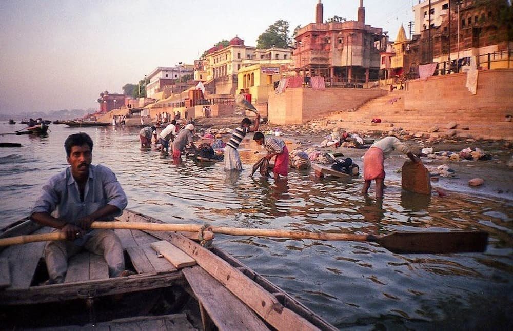
Varanasi is the spiritual capital of the Indian subcontinent. Also known as Banaras, or Kashi, commonly known for the Shiva temple, the region boasts of a rich religious history in Hinduism, Buddhism, and Sikhism.
The view from the ghats of Varanasi (embankments along the river using stone slabs as steps) is stellar and is the place for performing ritual ablutions like “Aartis”. Taking a dip in the river Ganga is considered very sacred. You can absorb the beauty of ghats of Varanasi on a morning boat ride.

Madurai is the ancient temple city, commonly referred to as the ‘Athens of the east’ for its amazing skyline, adorned by 14 vibrant colored ‘gopurams’ (gateway of the temple).
Dravidian style Meenakshi Amman Temple covered in bright carvings of Hindu gods, stands as the most amazing religious shrine from the past. Soak up the energy in Madurai by attending the Chithirai festival in April!

The Ajanta and Ellora caves are massive carved caves situated in the Aurangabad region of Maharashtra. The caves stand as a memorial to the evolution of Buddhism and Jain culture throughout the subcontinent. Beautiful sculptures, engravings, meditation rooms, and prayer halls will transport you back in time.

Akshardham Swaminarayan temple in New Delhi is an aesthetically flawless architecture that embalms the heritage of Indian culture and Hindu spirituality.
Located adjacent to the river Yamuna, the temple was built in congruence with Vastu Shastra and Pancharatra Shastra. Ornately carved pillars, statues of Sadhus, and domes covered with intricate designs of flowers, dancers, deities, and musicians; make it a prime example of temple architecture from across India.
So what are you waiting for? Pick your destination and pack your bags. By the way, don’t forget your camera to capture those spellbound moments!
After an 8-hour flight from San Francisco, we arrived at Keflavik before the crack of dawn, groggy but excited to embark on a two-week adventure around Iceland. The airport, while relatively small, shows small signs of a country that has been hit with a deluge of tourists – from the areas being constructed to accommodate more foot traffic, to the multiple billboards advertising everything from Icelandic yogurt (skyr) to the über touristic Blue Lagoon.
It’s also upon arriving that you immediately notice how expensive everything is – particularly food. Sure, airport food is always marked up but when you buy a small pastry for US$7 even that’s excessive by international standards. But of course, in a country that still continues to form through volcanic explosions, glacier avalanches, and harsh winters, it’s no wonder that consumable items don’t come cheap.

Keflavik is about one hour away from the capital, Reykjavik, and the best way to get into town is by FlyBus, a passenger coach. From the bus terminal in Reykjavik, we changed to a minibus which then dropped us off at our Airbnb around 7 am, located right in the center of the city.

We were excited to stay in our Airbnb, our home for the next week, which we would use as the base for multiple activities and tours – including snowmobiling up the second-largest glacier in Iceland, Langjökull, to snorkeling between two tectonic plates. Iceland apparently buys the most books per capita in the world and our hosts certainly supported that statistic. Their living room had a floor-to-ceiling, wall-to-wall bookshelf stacked full of books in Icelandic and English.
The home was cozy, with well-heated rooms that meant that wearing shorts and a t-shirt indoors (despite it being a mere 2 degrees Celsius outside) was possible. People don’t sleep with a top sheet, so each bed had a duvet on it for every person (Icelandic couples don’t share), which proved to be incredibly hot the more you settled into it. We woke up in a pool of sweat the first night, not realizing how warm the covers become. It was like they were made out of some magical material that absorbs your body heat to stay warm as long as you sleep.
With so many waterfalls and glaciers throughout the country, Icelandic tap water is the purest in the world to drink – so do visit Iceland with an empty water bottle so you can fill it up virtually anywhere. Hot water is powered by geothermal hot springs, which have the intense scent of sulfur (not harmful) – so be prepared to smell rotten eggs while you shower!
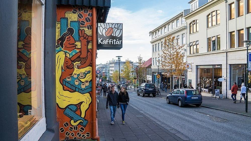

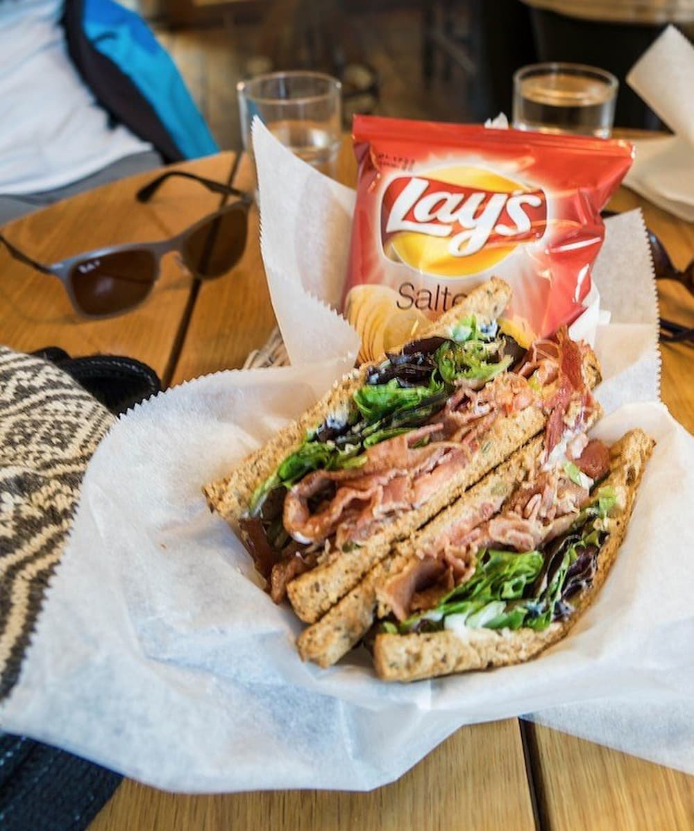
Two-thirds of Iceland’s population (about 200,000 people) live in Reykjavik, and the city is very easy to explore on foot. The streets are flanked by stores targeting the omnipresent tourist – from the shops advertising Icelandic wool sweaters to English, Irish and American-style pubs and bars serving everything from fish and chips to hamburgers. We stopped at a café for lunch and were treated to an expensive (but delicious) BLT sandwich and coffees (including a
We stopped at a café for lunch and were treated to an expensive (but delicious) BLT sandwich and coffees (including a licorice-flavored brew – if you’re a licorice fan you’ll love it here, they seem to put it in everything from ice cream, chocolate, and even popcorn)!
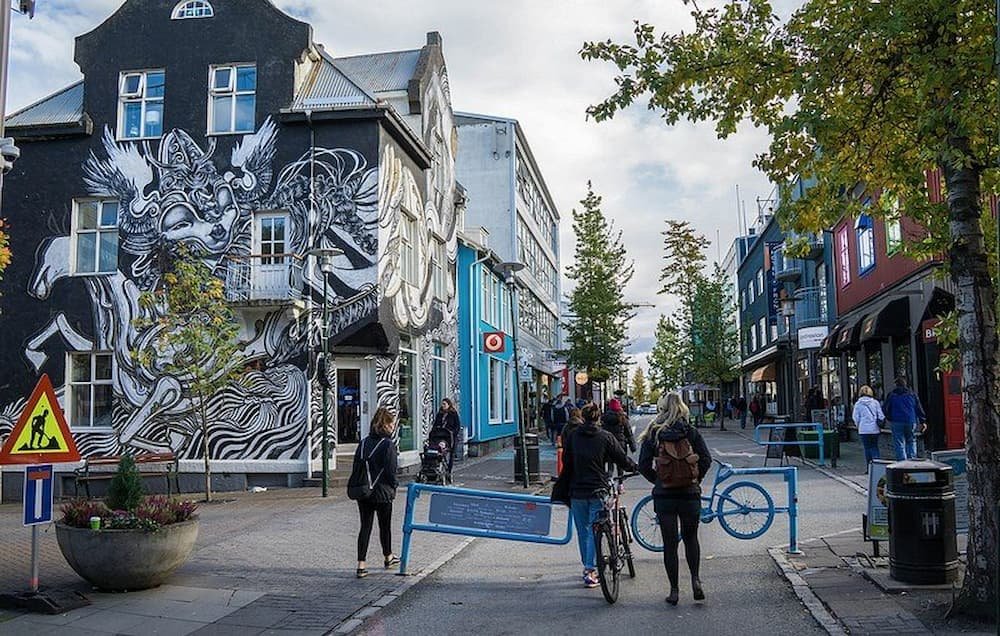
The city is very artsy – there are countless murals around the city, and street art is rife. The houses have a European flair to them, with colorful houses popping out even against the bright blue sky (we were lucky with the weather, I imagine the colors are essential during the grey and long winters).
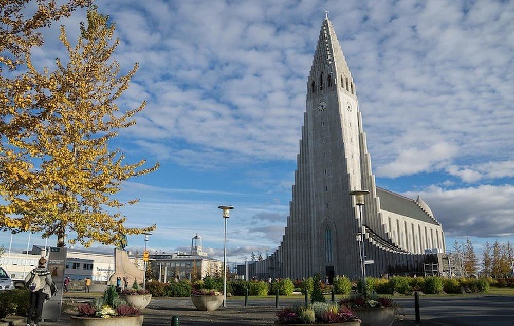
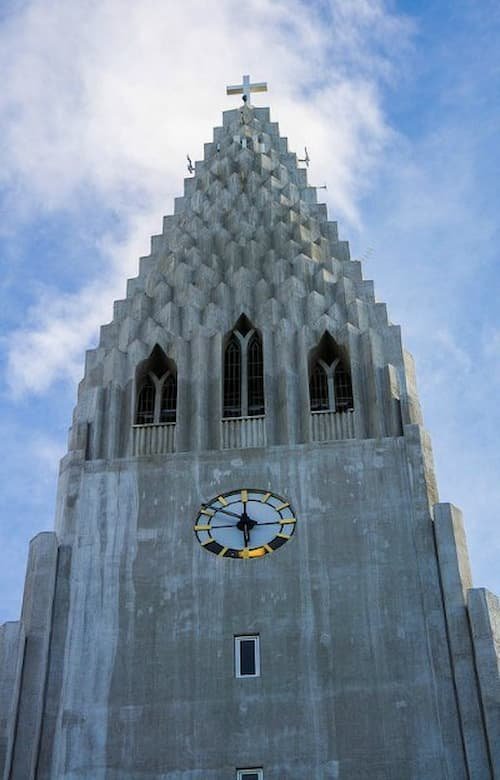
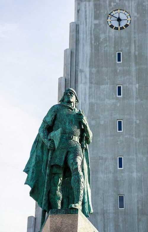
We checked out Hallgrimskirkja – the tallest church in Iceland and flanked by an imposing Viking statue. The interior has a minimal design like most Lutheran churches and also houses an impressive organ with 5,275 pipes that are 10 meters long. You can also take an elevator ride up to the top of the church to see breathtaking, 360-degree views of the city – including geysers in the distance puffing up wisps of hot air into the sky.

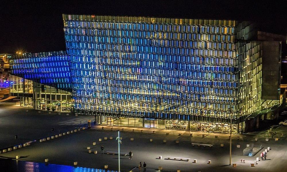
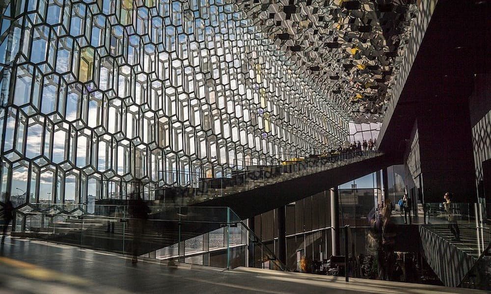
Along the water’s edge, we found Harpa, a beautiful building that shimmers with its fish-scale shaped glass windows. Construction was paused during the height of the 2008 financial crash, but the Icelandic government decided to complete it and it’s now home to various operas, conferences, and musical performances. You can enter the building for free, sit on one of the cushy seats inside and see the city sparkle from within. Walking further along the water, you’ll also find Solfár, a striking sculpture of a Viking ship that glimmers by the water’s edge.
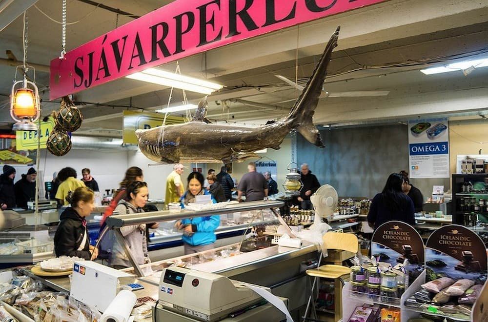
On the weekends, there’s a flea market a few blocks away from Harpa, where you can sample Icelandic delicacies. We tried more licorice and pastries, as well as Hákarl – Greenland shark. Not for the faint-hearted, the shark needs to be fermented for six months underground to be edible – and still has the strong smell of ammonia as you put it to your lips. It has a rubbery texture to boot – no wonder you need a shot of Brennivín (traditional Icelandic schnapps made from corn and accented by caraway seeds) after eating it! Besides shark, you can also purchase other meats, such as lamb, horse, whale, and salmon.
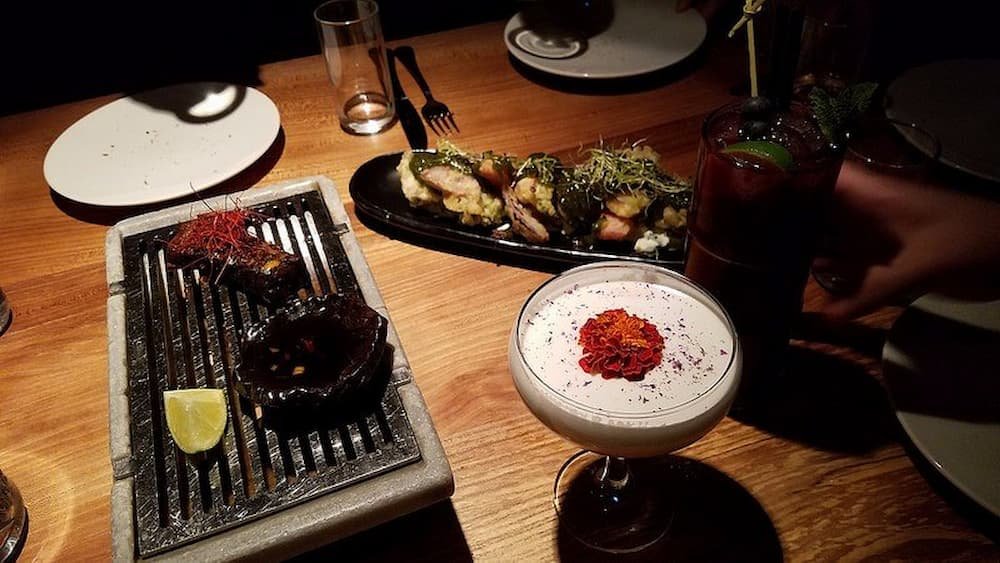
While food is expensive (even the 7/11 convenience store variety), if you’re a foodie it’s worth splurging one night at a restaurant such as Grillmarkaðurinn, particularly if you have a lot of people. We dined on incredibly tender lamb shanks, gorged on herb-encrusted gourmet potatoes and indulged in a decadent dessert that included ball-shaped chocolate that melted once the caramel sauce was poured over it. Make sure to also try a hot dog – they’re apparently “world-famous” and are lamb-based, with a mixture of pork lamb and beef, with toppings including onions, fried onions, ketchup, mustard, and remoulade, a sauce made with mayo, capers, mustard, and herbs.
For the museum buffs, Iceland caters to all interests – from the historical and cultural Húsavík Whale Museum (Húsavík) to the niche Industrial Museum (Akureyri) to the downright quirky Phallological Museum (Reykjavik). We checked out the Reykjavík 871±2 , a Settlement Exhibition, which is atop Viking ruins, that goes into great detail on Viking life when they first settled in Iceland.
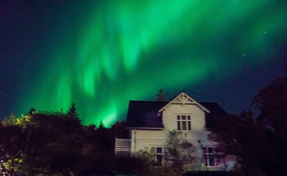
We were fortunate to be in Iceland during the start of prime viewing season for the Aurora Borealis, commonly referred to as the Northern Lights. Around 10 pm on three several nights, we saw the northern lights dancing around the city, shimmering with shades of green and white, and underlined with tones of purple at times. Reykjavik even imposed a city-wide lights out night from 10-12pm one night, so that people could enjoy the northern lights without any artificial light pollution. That night, the lights flickered on and off at different intervals, while we waited under the cold night sky, marveling at how fortunate we were to see such a natural phenomenon but also at how small we are in the universe.


That rush of excitement and the pleasure you get when you’re in an entirely different place is without equal. There is nothing more gratifying than exploring the wonders of a place you’ve never been before.
Palawan would have to be one of those few places in the world you’ll never get tired of visiting. One visit is not enough to unravel the beauty that this island holds, and every time you set foot on this island paradise, it will always leave you in awe like the first time.
Pristine beaches, vast sand expanses, glistening turquoise waters, and a long list of unspoiled natural wonders are reasons why this island in the Philippines bears international recognition. The allure of Palawan is not only for local tourists but foreign travelers as well.
Though the number of attractions in Palawan is staggering, we’ve rounded up the 11 best spots in – El Nido, Palawan.

It’s quite relaxing, having a place all to yourself. Palawan is blessed with so many bodies of water, and the Big Lagoon would have to be one of the most stunning attractions on the island. The location is simply magical with its blue-green waters and towering limestone walls that stand as barriers to a more private experience. With its unique location, Big Lagoon is a must-visit destination in Palawan.

With the multitude of pristine beaches on the island, Nacpan Beach is one of the well-loved beaches on the entire island. This beach has long, wide shorelines perfect for you can enjoy walking barefoot on. The place is perfect for surfing, and snorkeling; almost every water activity is noted down on your list. The serene atmosphere makes relaxing by the seaside an effortless undertaking.

Serenity – the word that best describes the charm that wraps up Corong Corong Beach. Tropical vacations usually call for lively beach settings and never-ending beach fun. At some point during the day, though, we all want to wind down in the quiet, and Corong Corong Beach can offer just that. The peaceful atmosphere of the shoreline makes it the perfect place to witness the blazing sun in the far distance. Sunset watching in Corong Corong Beach is one of the most stirring experiences you’ll get on the island of Palawan.

Another secluded attraction on this island is the Secret Beach on Matinloc Island, also a part of El Nido, Palawan. This piece of Paradise is concealed by massive cliffs encircling the area. The only way into the secluded beach is a narrow fissure in the cliffs. Accessing this natural wonder might be quite a challenge, but this piece of heaven behind limestone walls is worth all the effort.

Just when you thought you’ve seen enough mystical sites for the day, wait until you get a glimpse of the captivating Cathedral Cave. With its unique formation, this cave in Palawan makes you feel like you’re in a totally different world. The cave forms part of a limestone island that can only be accessed by boat. Cathedral cave has been dubbed so because its high ceiling resembles that of the stunning upper interiors of a cathedral.

Paradise beach is like a beach setting cut out from a postcard. This picture-perfect destination in Palawan is a dreamy setting of white sand, shade-giving palm trees, and the soothing blues and greens of the sparkling waters. Another staple in an El Nido, Palawan vacation, Paradise Beach is an ideal place to enjoy the underwater sceneries. The peaceful atmosphere will make you feel like spending time on your very own private beach.

A scene cut right out of the movies, Cadlao Island is a piece of paradise within a paradise. The jagged mountain walls and limestone karsts surrounding the island adds to the feeling of a faraway tropical haven. The white sands and clear turquoise waters add up to the captivating beauty that the island already holds. Being the largest island in El Nido, Cadlao provides one of the best seaside views in Palawan.

If there’s one thing seasides are known for, it’s the soothing sunset-watching sessions. Nothing beats the experience of witnessing the glow of the high heavens while basking in the wide-open shores in the cool salty breeze. In Las Cabanas Beach, you can have an outstanding view of the blazing star by the coast. The stillness of the place provides an even more relaxing experience in this natural art show.

Papaya Beach is a gem on the beachfront. It is one of El Nido, Palawan’s best beach spots where it bestows the grandest views of the island. Not only is it the perfect location to enjoy the island’s natural vistas, but it is also the ideal spot to have some fun in its vast sandy expanse. The fine powdery white sand and the lush greens of the rainforest give you a faultless beachside experience.

What’s not to like about this socially magnificent beach escape? Not only does it hold the luxury trappings of a relaxing beach setting, but it is also an ideal place for basking in the sun. The long and wide bed of fine white sands hemmed in by blue-green waters sets a perfect venue for beachside gatherings and feasts. The place not only accords a sensational view but an engaging coastline experience as well.

El Nido’s highest peak is a fortress of natural elegance. The quest of successfully scaling the ragged summit offers one of the most exhilarating island experiences. Taraw Peak also hands over one of the most breathtaking seaside views there is. Aerial shots are heavenly on their own but it gets even more enchanting when it grants you an exceptional panorama. Being on top of the highest peak in El Nido is nothing short of capturing a flawless seaside view of this active town.
While flights do go from Manila to El Nido, few airlines fly the route. An easier option is probably to fly to Puerto Princesa International Airport and take a shuttle or bus to El Nido. Ferries from Coron are also an option for those uninterested in flying.
1. A sarong – While El Nido is known for its beaches, the district is actually quite conservative so you should bring something else to cover up your swimwear.
2. First aid kit and medicine – Medical facilities on El Nido are rare with essentially only one center serving the entire township. You should bring some medical supplies in case of emergencies.
3. Pesos – Withdrawal and non-cash options in El Nido are quite limited. Currency exchange shops may also charge a premium. You should get your Pesos ahead of time.
While there are long-distance buses carrying passengers into the El Nido township from nearby cities, tricycles are more commonly used within the township itself. There are piers and seaports available as well making boat trips another option.
El Nido has little phone coverage meaning visitors will have to rely on the internet and satellite phones. However, Palawan and the Philippines as a whole have issues with an insecure and unreliable WiFi connections. Visitors should either bring their own portable WiFi devices or pick up a VPN for the Philippines to encrypt and speed up existing WiFi speed.
El Nido is definitely a place full of pleasure and excitement. Your journey to this island paradise will be peppered with vistas of the natural wonders exhibited before your very eyes. With the multitude of natural attractions enclosed in this beautiful island destination, you will never run out of places to capture awesome sites.
Immerse yourself in nature without limits, with the sensational and impressive landscapes of Greenland.

I’ve always searched for wild places and a taste for adventure, and this growing urge led me to begin three expeditions to Greenland.
For a total of more than three months, I hiked, kayaked, sailed, and dogsled through the vast island. I was also able to immerse myself in the culture by living with the Inuit, who taught me how to survive the icy, unrelenting weather.
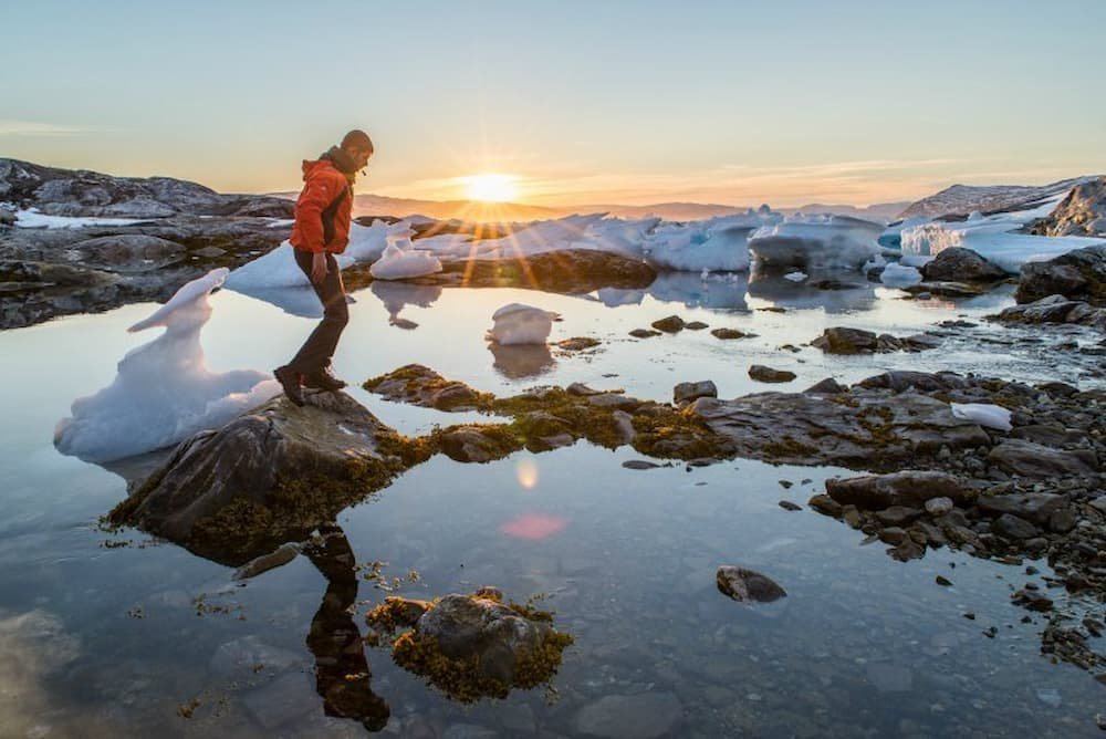
I couldn’t have imagined the wide variety of feelings I experienced during the first month spent in Greenland. I was moved by the contemplation of the wild untouched landscapes I had crossed, fascinated by the enormous icebergs, and truly inspired by this island’s people.

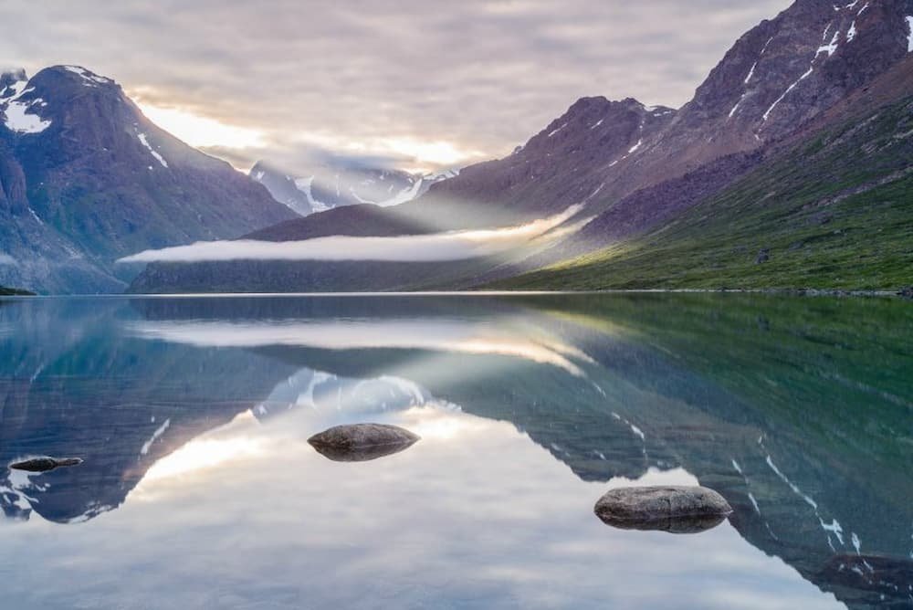
Imagine somewhere away from remotely tucked away from all traces of human life. Here, you can see a valley filled by a calm and a greenish-blue lake that bounces back your reflection. Bright green mountains symbolize the welcoming atmosphere of the land. Two thousand meter-high peaks fall steeply into the water as if to highlight how small we stand in comparison. Mountain passes and snowy summits relinquish melting glaciers, reminding us that nothing is eternal. Finally, there’s a bright sun to warm our hearts and a sandy white beach, where you can rest all day and contemplate the beauty of the universe.
This is quite simply the beauty of Greenland. It’s here that there seems to be an invisible force that keeps nature, and our body and soul, in equilibrium.

After being caught up by a storm that was 15 degrees Celsius below zero and a blizzard whipping winds of 160 km that restricted our visibility for a few days, Angani, an Inuit from Kulusuk, and I set off on a dog sled to hunt for seals, polar bears or whatever else we stumbled upon. In Greenland, hunting is not a sport but a way of life. In the Ammassalik region, the Inuit have always survived with the bare minimum amount of food, given this area is surrounded by ice for nine to ten months a year. It is one of the most remote areas in the world, which has led to the creation of a dialect called Tunumiu, different from the normal Greenlandic language.
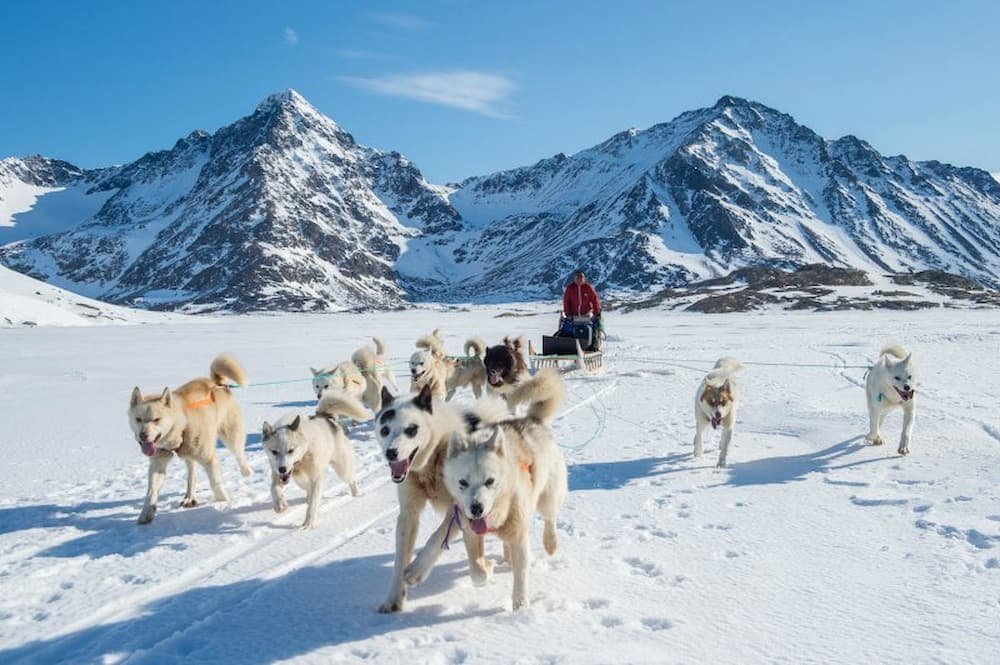
It is April, and a spring sun has already shown up. The sled glides a dozen kilometers per hour, the dogs struggling in the soft snow and melted ice due to the abnormally high temperature for this time of the year. The dogs here endure the cold, blizzards, and storms, but this weather is now almost too warm for them.
Angani screams, “Yoyo yoyo yoyo yo!”, which echoes in the air and directs the dogs to turn left. Suddenly, Angani stops the dogs, and silence lingers in the valley. The dogs sense that it’s hunting time.


Giving me a quick look through his rifle lens, Angani excitedly says, “Puisi, puisi”, which means “seal” in Greenlandic. Dressed in a white painter's suit with his gun slung over his back, he walks slowly towards the seal.
The seal, which had been sunbathing, looks up every 30 seconds to keep an eye out for predators. Every time the seal looks up, Angani stops and waits before walking toward the seal again. When Angani is close enough to shoot the seal, he lays down on the ice, holds his breath, and pulls the trigger. The seal, wrapped in a layer of blubber, is able to slide down quickly into his ice hole. Angani comes back with no prey. Hunting requires much patience. Another Inuit had spent over five days looking for a polar bear, without ever finding it. It’s like looking for a needle in a haystack.
My days are spent blowing cold embers to rekindle the fire, heating water for tea, running a photography time-lapse, collecting firewood, watching the weather, spotting the next passage of the river to cross, and finding a place for the campsite.
These simple actions take on new meaning when you live minimally, and are so close to nature. I’ve been fortunate enough to experience this on different expeditions, wandering through various countries and landscapes.

Benefiting from these experiences has allowed me to have a better understanding and appreciation of protecting the environment, and preserving age-old Arctic traditions and customs.
As I’ve gone on long hikes and reveled in the beauty of a wild place, it’s always been important to take care of the fragile and unique beauty of places like Greenland. The landscape is so unreal that pictures carry only a sliver of magic. But my hope is that they inspire others to seek out traveling to these places for their own peace and serenity.

I arrived in Greenland with a very heavy backpack, loaded with food and water. Over time our resources depleted, making our bags lighter – but now I am filled with memories and emotions from my time here.
I believe that photography can make a real connection to people, and can be used as a positive tool for understanding the challenges and opportunities of tomorrow. Photos can convey so much to a person, and now that I’m going home, I’m ready for my next adventure.


Iguazu Falls, which stretches across the border of Brazil and Argentina is one of the most impressive waterfalls in the world. Made up of about 275 waterfalls and cataracts spanning 2.7 kilometers wide, Iguazu Falls are twice as tall as Niagara Falls and on average, has 1,500 cubic meters flowing every second. It’s no wonder then that Iguazu Falls become a UNESCO World Heritage site in 1984 and was a winner of the New Seven Wonders of Nature competition in 2011.
Iguazu Falls are located within one of the few remaining inland rainforests in South America, which means that more than 2,000 plant species, about 400 bird species, 80 types of mammals, and countless insects and invertebrate species reside in the area. If you have time, check out both the Argentinian and Brazilian sides of the falls – both will provide a very unique experience.
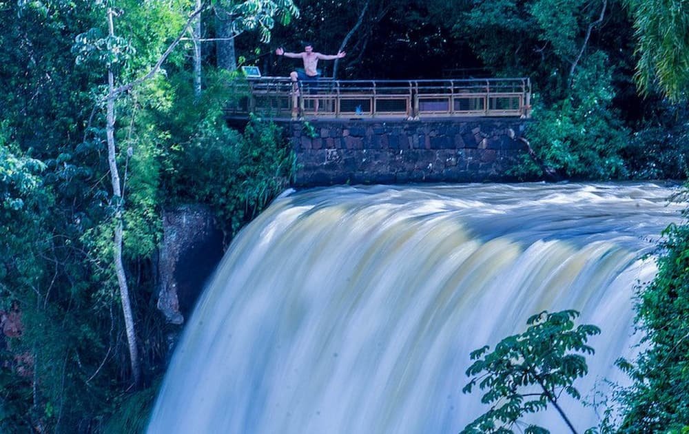
Known as Foz do Iguaçu, the Brazilian side of the falls is a great place to start your adventure as there are fewer trails to navigate and you get a much broader idea of the scale of just how big these falls are. Make your way down to the Devil’s Throat and walk out along the boardwalk to get up close and personal.

This is at the start of the trail. Already drenched in sweat!

One of the many viewpoints along the trail where you can snap a great shot of the falls

A double-tiered section of the falls

Here you can see a major section of the falls (about 1/4 of the entire length is shown here)

Prepare to get soaked when you walk out along this boardwalk

Tourists posing for their obligatory photo

Looking out over the top of the Devil’s Throat on the Brazilian side

The viewing platform

So excited to be here

“The falls are this big”
Three-quarters of the length of Iguazu Falls are on the Argentinian side, so if you really want to experience the waterfalls and be blown away by their magnitude, spending at least a day here is a must. You can walk right into the heart of the falls, spend time walking across many trails leading to different viewpoints, and even take a boat ride that takes you right underneath the crashing waterfalls. It’s a good idea to bring a swimsuit if you plan to do this or visit in summer, as the weather is very hot and humid.

So many trails, so little time

If I jump high enough, can I be as high as a waterfall?

One of the many walking trails leading to a lookout point. It can be slippery when wet (so that means all the time)!


Chasing waterfalls and rainbows
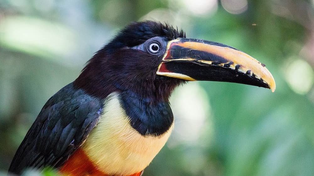
One of the other major attractions during a trip to Iguazu Falls is the wildlife. There is a fun and impressive Bird Park where you can really close to and interact with over 160 species of birds, and also see butterflies and reptiles. On your way to the waterfalls, it’s also common to spot tapirs, giant anteaters, howler monkeys, ocelots, caymans, and even jaguars. One of the most common animals to see while you’re strolling along a walking trail is a coatimundi (or coati) – a relative to the raccoon. While they may look cute – and many visitors try to get up close and personal – these animals are known to be quite ferocious, so stay clear of their sharp claws!

Tortoise chilling and enjoying life

Vividly colored macaw

Impressive hairdo

I feel like this butterfly is watching me closely

Cute little lizard

These coatis look cute, but can be aggressive – don’t give them food!

Monkeying around

A very bright toucan looks just like it does in the cartoons

Favela. Commonly translated as “slum”, these are communities with low-income residents in Brazil. At best, favelas evoke images of colorful brick and cement houses full of vibrancy and activity; at worst, favelas can elicit ideas of substandard housing and squalor, and communities terrorized by drugs and crime.
The term favela was coined in the late 1800s after tens of thousands of veteran soldiers were transported to Rio de Janeiro following the civil war, and found themselves with no place to live. With increased urbanization taking place in Rio, today one in four people live in the 950 favelas stretched across the city. If you count the entire country, six percent of the country’s population lives in a favela.

I’d heard about favelas before coming to Rio from friends who had talked about them with hushed warning tones: “Be careful when you’re in Rio, you’ll find yourself in a nice part of town and then realize that a favela is right behind you. You’ll want to be careful.” These same friends had also mentioned that they’d taken a tour of a favela though, so I decided to make up my own mind with Favela Tour, founded by Marcelo Armstrong, who pioneered visits to favelas for tourists back in 1992, when the idea was completely unheard of.


Fluent in English, Portuguese, Spanish, French, and Italian, Marcelo worked in tourism previously, and it was upon returning to his hometown that he decided to set up the tour. Marcelo mentioned that when he started this tour, a lot of times the people in a favela were just as curious as the tourists, but today it’s only the tourists who are interested – favela residents are used to the attention. Marcelo also stressed that the favelas we would be visiting would be extremely safe, as they had not only been rid of the drug lords years ago by the police but an agreement had been reached with residents not to harm tourists – and if anything did happen, there’d be serious consequences.
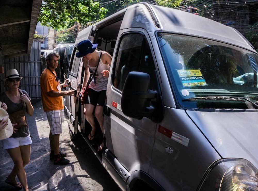
We were picked up from our hotel for a three-hour favela tour on a hot February afternoon, and whisked straight to Rocinha, the largest favela in Brazil. More than 70,000 people live in Rocinha, with unofficial estimates pegging the population at up to 180,000.
Driving into this favela, I was struck that we were in a city within a city. There were stores selling groceries, clothes, and other consumer goods, banks, pharmacies, and restaurants.
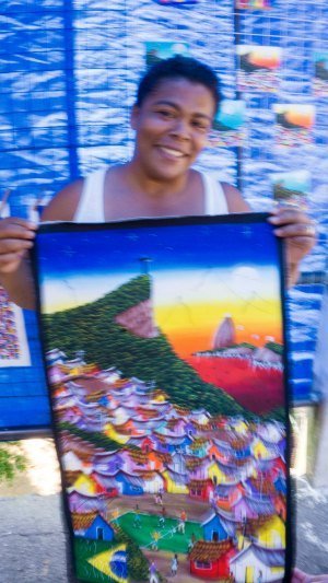
There were people peddling their art, jewelry, and handmade items for tourists interested in a bargain. There were paved roads snaking up the hill, carrying buses, motorcycles, and cars. But what was possibly most striking was the jaw-dropping view of this favela, built on a steep hillside overlooking Rio.
We were able to see the favela in its full glory on a terrace of a house, looking at all the colorful houses being built on top of each other, stretching out towards the beach.

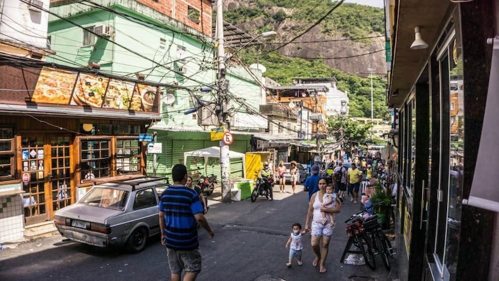
We walked a bit further towards the main road that led out of Rocinha to a massive sports center, an adjacent samba school and even saw a former F1 race track. My impression was that this favela was fairly established and probably had some middle-class residents – there was clearly sanitation, running water, and electricity that helped to support this community.

Our next stop was a smaller favela, Vila Canoas. As we visited the favela during the week of Carnaval, unfortunately, we weren’t able to visit the school and see the local kids (the cost of the favela tour helps to finance the community school), however, we did see the playground and a wall filled with colorful mosaics of butterflies and flowers outside – and a staircase stacked with positive words painted in blue.

Vila Canoas contrasted with the hustle and bustle of Rocinha – it was much smaller, with narrow paths that you could only access on foot. Rather than walking uphill as we did in Rocinha, we trekked down passageways to get further into Vila Canoas, with alleys splitting off in multiple turns. I felt like I was going down a rabbit hole. Again, however, the favela did show signs of vibrancy – we stood at the front door of a resident who had lovingly decorated a common walkway, with plants, lights, and color for people to appreciate as they passed by. At one point, my eyes followed a narrow stairway that led to an open door. Inside, I could make out a refrigerator and a young boy and his mother in the kitchen eating. In another house, I could see two girls hanging around outside on chairs and talking. These were scenes of home life that could be echoed anywhere else in the world.

Throughout the tour, Marcelo’s passion for educating people about the realities of favelas was palpable. He was engaging and while he emphasized his desire to get rid of the negative perceptions of favelas, he also talked about the ongoing political and corruption issues pervading the country that meant that for many, it’s difficult – if not impossible – to get out of the cycle of living a low-income life in a favela.
Yet these favelas highlight the social contrasts of the country. Certainly, there are favelas that would undoubtedly be off-limits to a tourist – they’d be more dangerous, less well-trodden, and you wouldn’t dare go there without a local. But there are also a lot of bright sparks within a favela – from the brilliant colors of the buildings, the smiles on the faces of the people, to the basic comforts in this city within a city.
All in all this was an insightful look into the social structure that exists in Brazil and definitely an experience I can recommend if you are visiting Rio de Janeiro. Be sure to book one of Marcelo’s tours through his website here.
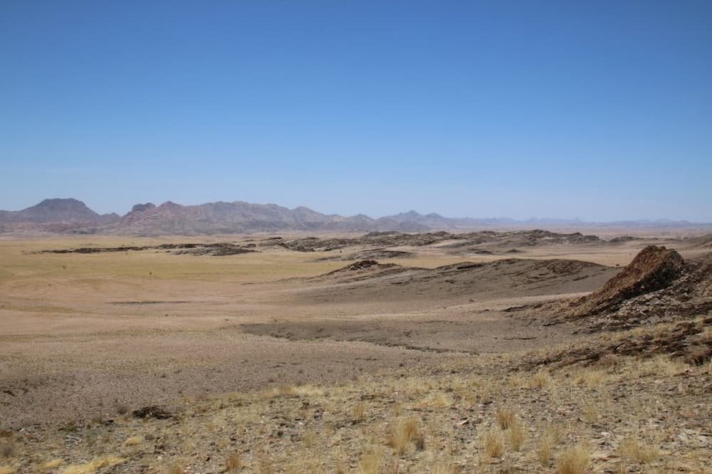
A Namibian safari is something that you will never forget: incredible vistas, surprisingly varied ecosystems (considering a lot of it is desert), and wonderful wildlife experiences. Experiencing Namibia as a self-drive is highly recommended as you have the opportunity to stop whenever you want to simply allow your brain to comprehend the extraordinary scenery that you can see. It is the arid nature of the Namibian environment that makes an incredible visual impact on any traveler.
Sossusvlei features most often at the top of people’s most memorable experiences in Namibia – here, you can see iconic and rich red sand dunes, stark and white dried-up salt pans, and dark chocolate brown petrified trees dotted artistically across the landscape. You simply cannot take a bad picture here.
Dead Vlei in Sossusvlei, is visually stunning with gigantic star-shaped mountains of sand, encompassing at least half of the area. Nothing really prepares you for this unusual scenery and it takes a bit of getting used to, in order to comprehend the magnificence of it all.
Make sure you plan ahead and get up early so that you are at the main entrance gate as the sun rises. It is a long day but definitely worth it and you will probably return to your accommodation completely frazzled – both in body and mind!

Kulala Desert Lodge is located in its own private reserve that borders Sossusvlei; here you can get private access to the sand dunes. The great thing about Kulala is that you can sleep out under the stars on specially-made beds on top of your private cottages. And if it does get a little bit cold, then you can retreat to your other bed inside. The choice is entirely yours.
Magnificent sand dunes! Why not attempt to climb one of these? The views from the top are astounding.
Driving from Sossusvlei towards Swakopmund, you will have the absolute pleasure of traveling through the stunning landscape of the Namib Naukluft Park, which covers almost 50,000 square kilometers and is one of the largest conservation areas in Africa. Make sure you allow sufficient time to observe it. The roads are spectacular, so be sure to stop, take photographs, and have a picnic surrounded by space and silence.
Although Rostock Ritz is not actually in the Namib Naukluft, it is right on the very edge and it might as well be there with the scenery that it has to offer from the lodge. Put on your walking boots and hike the numerous self-guided trails based on the lodge’s reception.
Have your own mini-adventure and hike along the ridge tops keeping an eye out for zebra and oryx. You would be forgiven for thinking that these animals could not survive in this area, especially in the rocky areas, but be prepared to be very surprised! The colors of the area are astounding: rich ochre reds and pinks dotted with burnt brown scraggly bushes, a vivid green cactus, or a bright white vein of quartz. There is too much to take in and it’s worth simply sitting and enjoying the view – this is the essence of Namibia.
Rostock Ritz Desert Lodge is a lodge that blends beautifully with its environment, with minimal ecological impact. People that stay there are looking to immerse themselves in a desert environment.
Simply explore the surrounding area by walking one of the numerous trails. Make sure when driving that you stop frequently to take in the scenery.
A very popular feature of the Namib Naukluft Park is the Welwitschia Trail which lies just east of Swakopmund. Some of these plants are estimated to be around 1,500 years old and you can take a scenic drive along the Welwitschia Trail stopping at recommended points, one of which looks over a valley known as Moon landscape, which is obviously named! Take time here as the scenery is really eerie and it is hard to believe that you are still on Earth. Follow the route which is marked with stone cairns so you know when to stop and learn something new about the environment.
The Welwitschia plant is a botanical curiosity and there are large concentrations found along this trail. These weird species have separate male and female plants which are pollinated by beetles, which are also pretty rare, so it is a wonder that these plants have managed to survive for so long and in such an arid and inhospitable environment. The end of the trail is marked by one of the largest plants in the area and is certainly worth a visit.

Cornerstone Guesthouse, Swakopmund, is one of the friendliest places in Swakopmund and the owners’ knowledge is incredible. Stay at either their B&B or one of their self-catering apartments on the seafront.
There are numerous things to see and do at Swakopmund, ranging from water-based activities to desert safaris. Things to do include catamaran trips to see pelicans and flamingos, canoeing with seals, desert tours to see the smaller animals and a remote Sandwich Harbour experience.
Continuing up the coast from Swakopmund, suddenly you are away from human habitation with only the Atlantic Ocean crashing onto windswept beaches. This is treacherous for shipping and there are numerous shipwrecks along the coast, particularly further north in the Skeleton Coast National Park.
The coastal road is very bleak and arid despite the proximity to the sea. You may think that few things grow here, and you are probably right, however, just north of the turnoff to the Cape Cross Nature Reserve is an enormous lichen field where you can get out of your car and sprinkle a little water on the ground and see them all come to life. It is extraordinary.
Driving along this road you probably won’t have seen much wildlife but turning off to visit the Cape Cross Seal Reserve you are suddenly assaulted with the sound and smell of thousands of seals, a population increasing to more than 250,000. There are huge barking bulls, females calling for their young and black seal pups bleating pitifully for milk – it is a deafening cacophony enriched by the acrid smell of seal dung. Despite this rather unpleasant intrusion on your senses it is mesmerizing to watch the mini-stories within this seal colony unfold!

Cape Cross Lodge is set on the bleak Skeleton Coast and this harsh remoteness is what makes it so memorable.
Driving up the coast is awe-inspiring to see some of the shipwrecks and a visit to the Cape Cross Seal Colony is a must.
Moving inland from the coast, you can see stretches of land strewn with boulders, rocky outcrops, and geological formations in a multitude of colors. Namibia’s World Heritage site, Twyfelfontein, is an open-air gallery of over 2,000 rock engravings, representing one of Africa’s largest concentrations of important rock art. Estimated to be around 6,000 years old, it is believed that these pictures of creatures and signs were created by the medicine people to record their experiences among the spirits. These beautiful rock engravings are a connection to our past and a legacy to be protected.
There are a number of different trails to walk along to see these beautiful carvings, and they have been cleverly designed for different levels of fitness. Taking a guided tour allows you to learn more about the people once living in this harsh environment. There are even pictures of flamingos here, which makes you wonder whether the area had water, or whether it was from people who had traveled the vast distances from the coastline on foot.
Close by is the Petrified Forest where a cataclysmic event millions of years ago changed enormous tree trunks into stone, Burnt Mountain which burns a brilliant scarlet red as the sun sets, and the Organ Pipes which are another geological curiosity of the area.

Mowani Mountain Camp is beautifully blended into rocky outcrops and some of the luxury canvas rooms have outdoor baths and showers in the overhangs of the local rocks. Wake up to the peace and tranquility of the desert and the spectacular view onto the vast open plains of Damaraland.
A visit to Twyfelfontein is a must, and also a safari to search for the elusive desert elephants is highly recommended. Take time to watch the sun go down on top of the warm rocks and watch the colors change from pale golden yellow to deep russet red.
Traveling even further north from Mowani, there is the opportunity to explore the vast concession area that is home to a number of rare black rhinos. If you have the time then this is an absolute gem of a place and you will certainly be in the middle of nowhere!
Desert Rhino Camp works in conjunction with Save the Rhino Trust and here you can participate in tracking black rhinos. Be prepared for a full day of traveling and immersing yourself in the environment. The undulating terrain of Damaraland is very difficult to do justice in describing the scenery: if you are agoraphobic certainly do not come here. But if you are into ever-changing panoramic views, contrasting colors, and the sense of being in the middle of absolutely nowhere, then this is certainly the place for you.
The anticipation of seeing these endangered animals is well worth the full-day safari and you may even get the opportunity to see lions, hyenas, and other animals. It is the ultimate safari experience in an arid environment. And the best thing is that at the end of the day you can watch the sun set over the magnificent scenery – an unforgettable experience.

Desert Rhino Camp is in a vast private concession and the enormous luxury canvas has private verandas overlooking a vast expanse of scenery which is an absolute privilege to stay in.
Track adopted black rhino and other wildlife and experience the privilege of being in some of the most stunning scenery that you may ever have the opportunity to visit.
From Desert Rhino Camp the road winds its way through some incredible passes and over some amazing mountain ranges towards the large flat expanse of Etosha. Etosha National Park is one of southern Africa’s most spectacular wildlife reserves and its uniqueness in wildlife sightings justifies its title as the country’s flagship park. The enormous salt pan of Etosha, which means Great White Place, temporarily fills with water during the rainy season which attracts a host of flamingos and pelicans.
Normally Etosha is an arid area with water normally only present in the pans dotted around the park and these permanent waterholes entice many animals into drinking. The beauty of Etosha is that it has marvelous game sightings and the expectation of seeing something remarkable keeps you alert for hours on end.
Doing a self-drive across the park involves the excitement of planning a route trying to encompass as many waterholes as possible. However, don’t switch off when driving from one waterhole to the next, as some of the most incredible sightings can be seen away from these busy areas and you may have that unique opportunity of having a one-to-one with one of the “big five” game animals – a lion, elephant, Cape buffalo, leopard and rhinoceros. So keep your eyes peeled.
The beauty of driving yourself is that you can stop and look at things for as long as you want to and you don’t get swept up with other people trying to spy as many animals as possible. Some of the best memories when visiting Africa are collected by traveling at a slow pace and allowing the surroundings to speak for themselves. So pay attention to the smaller things, sit and relax at waterholes, and just enjoy the scenery – you never know what is coming around the corner.

Staying outside the park is much more cost-effective and there are many lodges that have their own waterholes as well, so you can sit in front of the floodlit arena and have your own play pan out for you. Try Ongava on the western border and Mushara or Onguma on the eastern border – all are unique and quintessential safari camps.
Wildlife of course! Immerse yourself in this incredible national park and make sure you give yourself enough time to cross it. Nine hours should be enough to cover 190km (118mi).
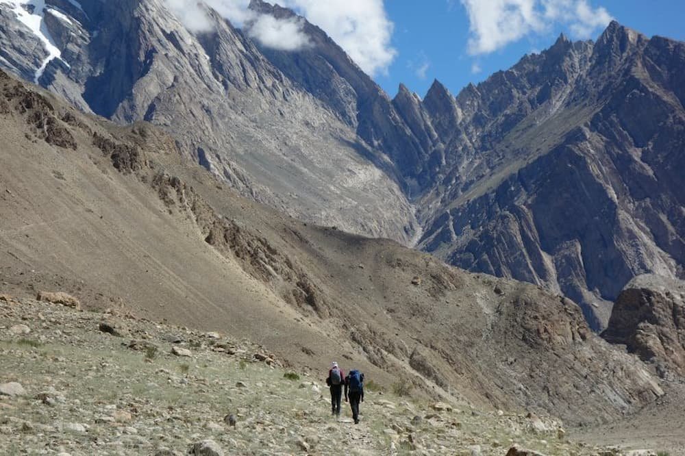
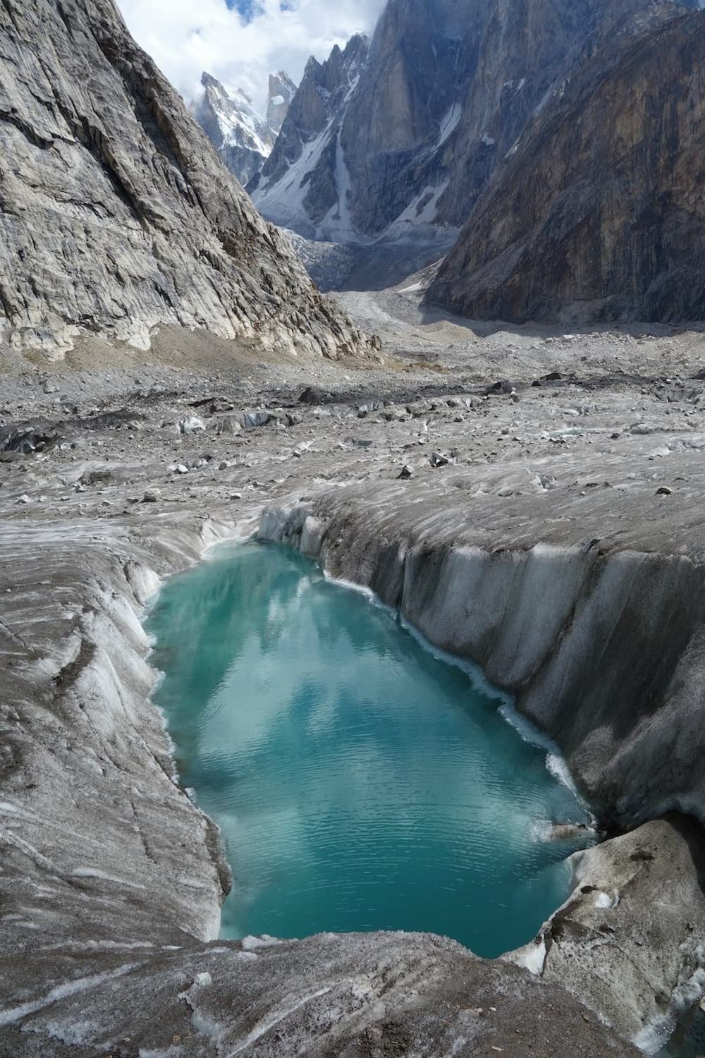
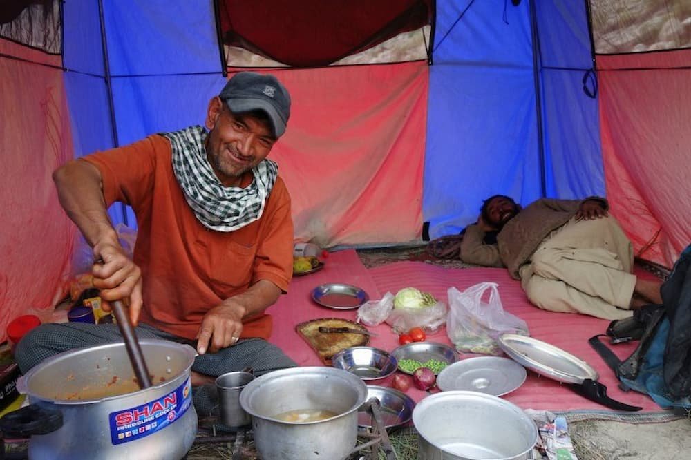
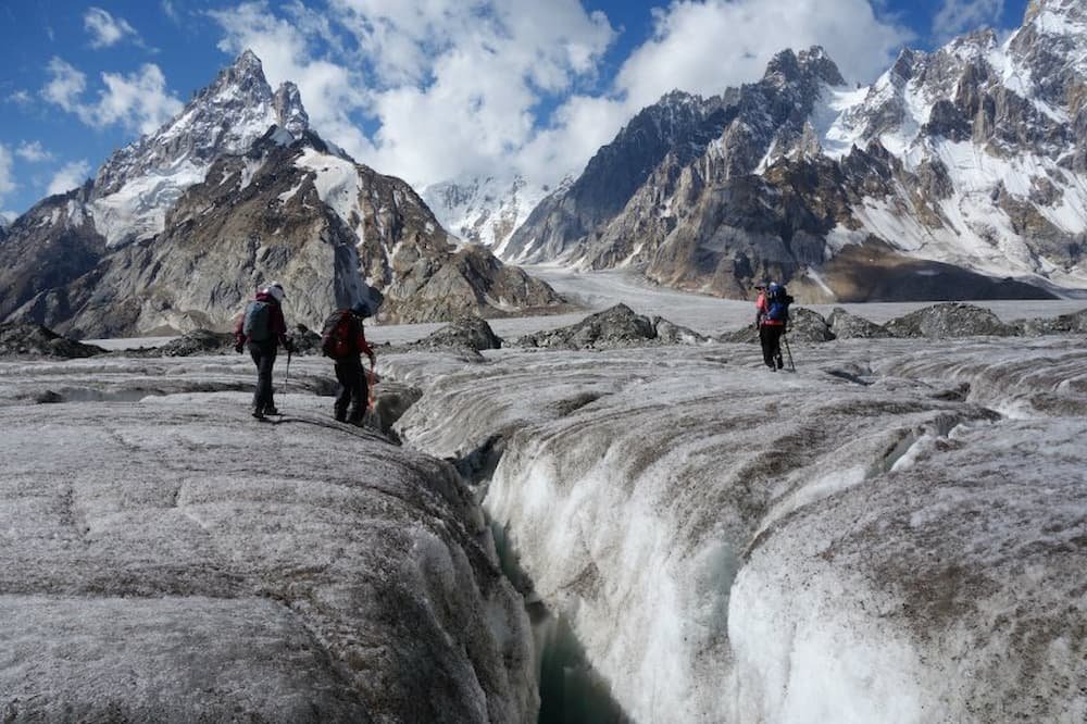
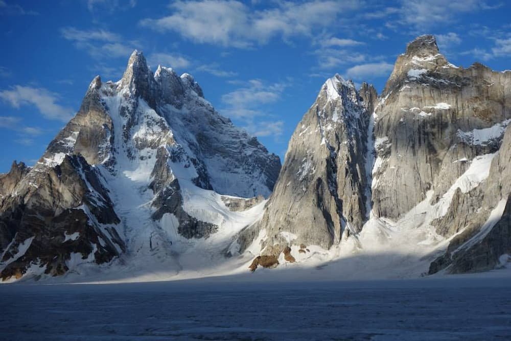
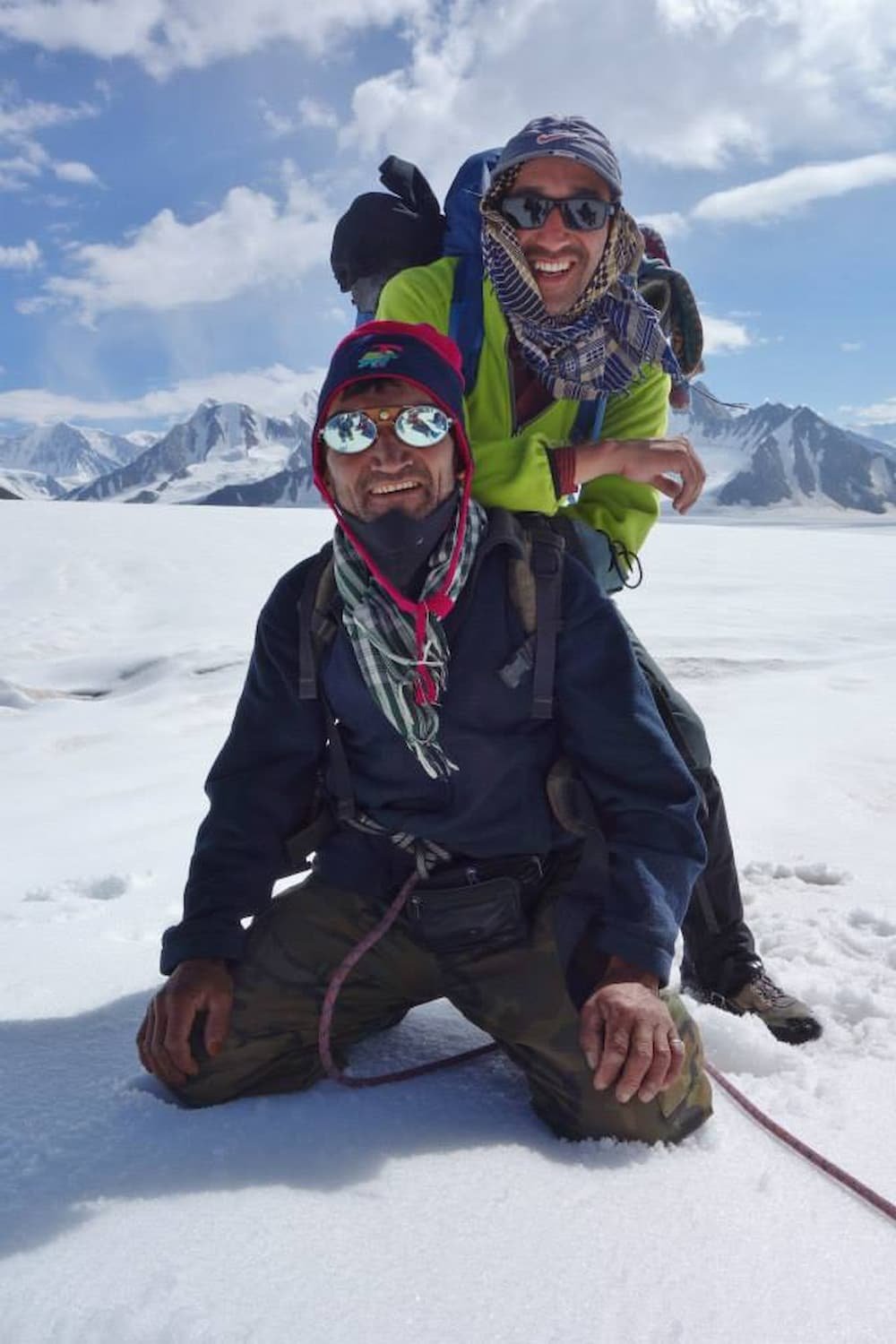
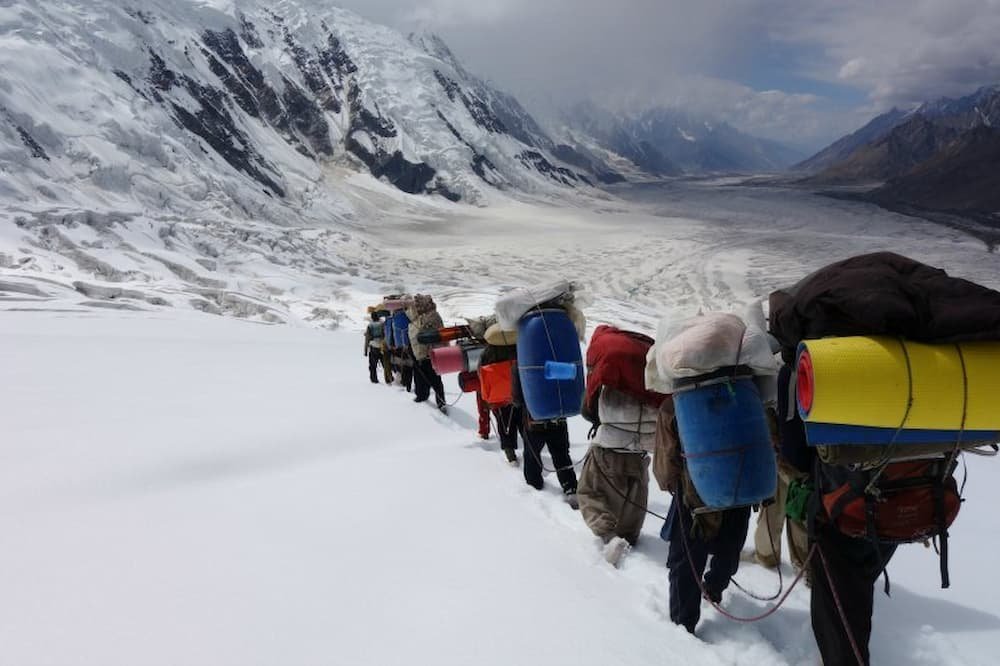
When you think of “trekking” most people might not immediately contemplate Pakistan. But the Northern areas better known as Kashmir, have some of the most majestic treks on the planet. The two most popular are the K2 base camp, where you can see the dramatic Karakoram Mountains while walking up the Baltoro glacier, and the spectacular Biafo Hispar glacier trek also known as Snow Lake.
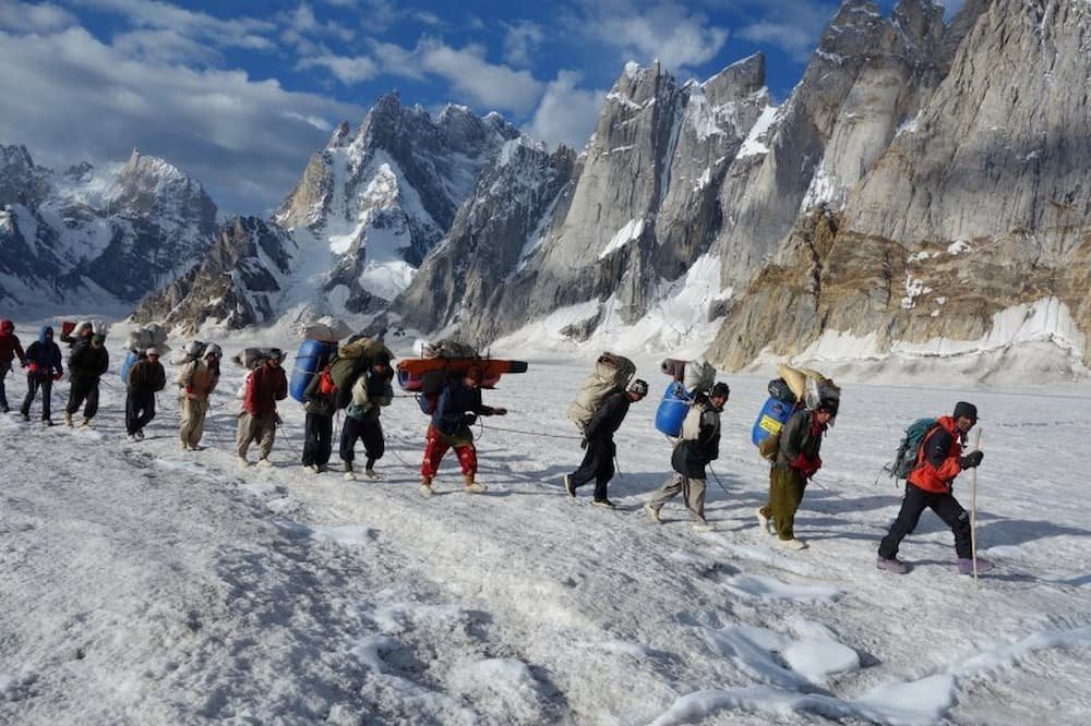
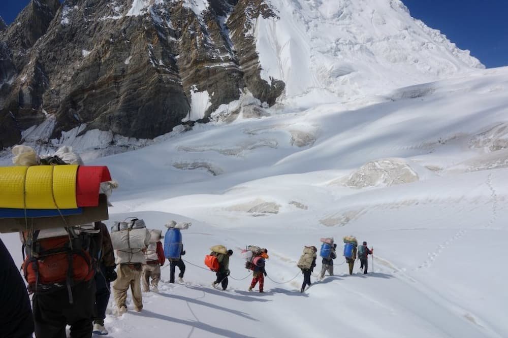
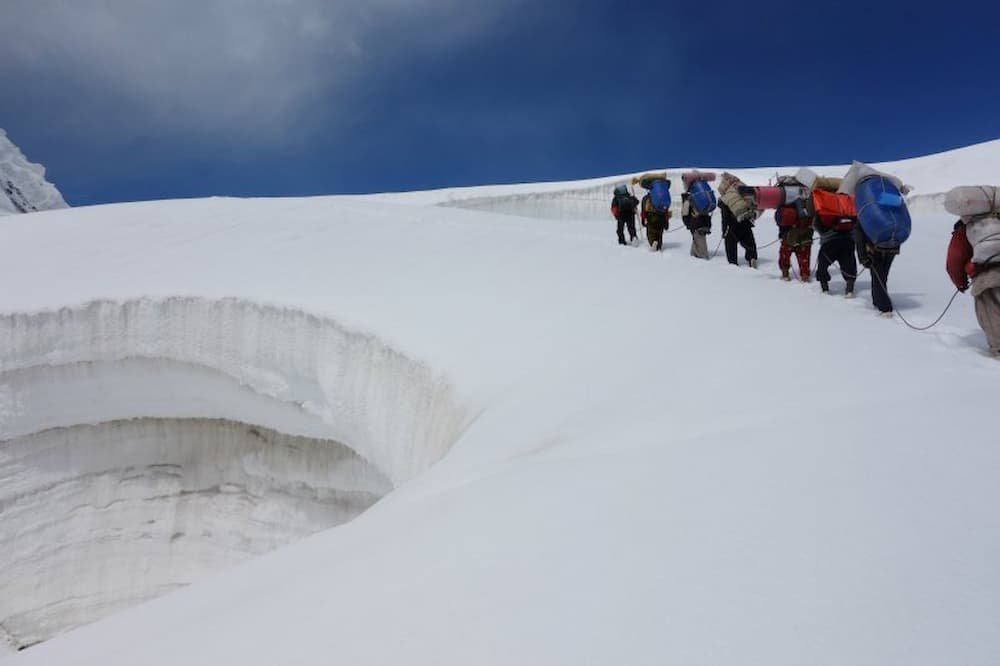
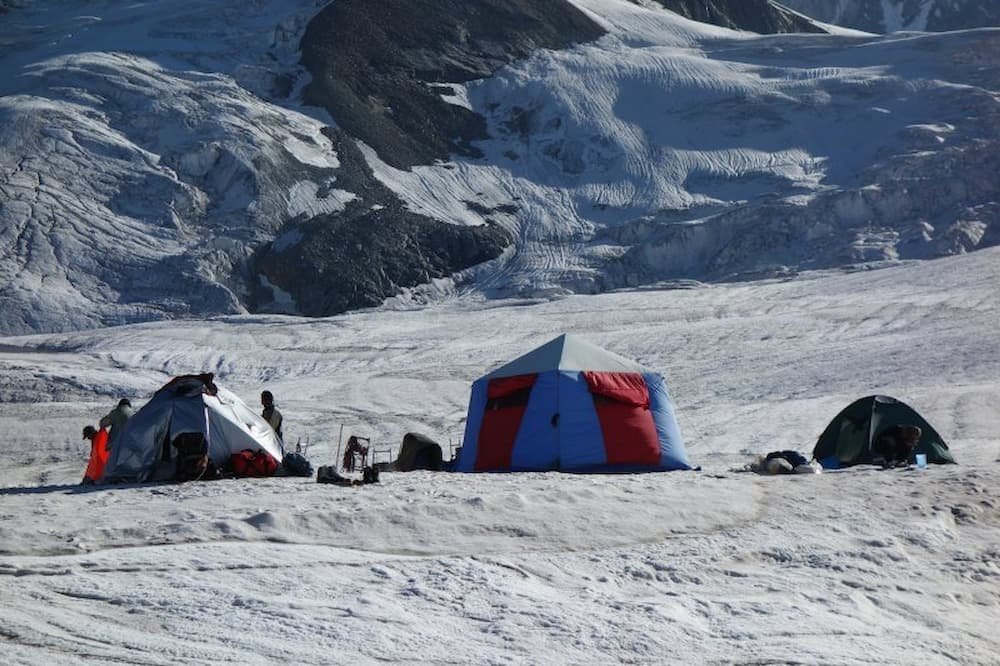
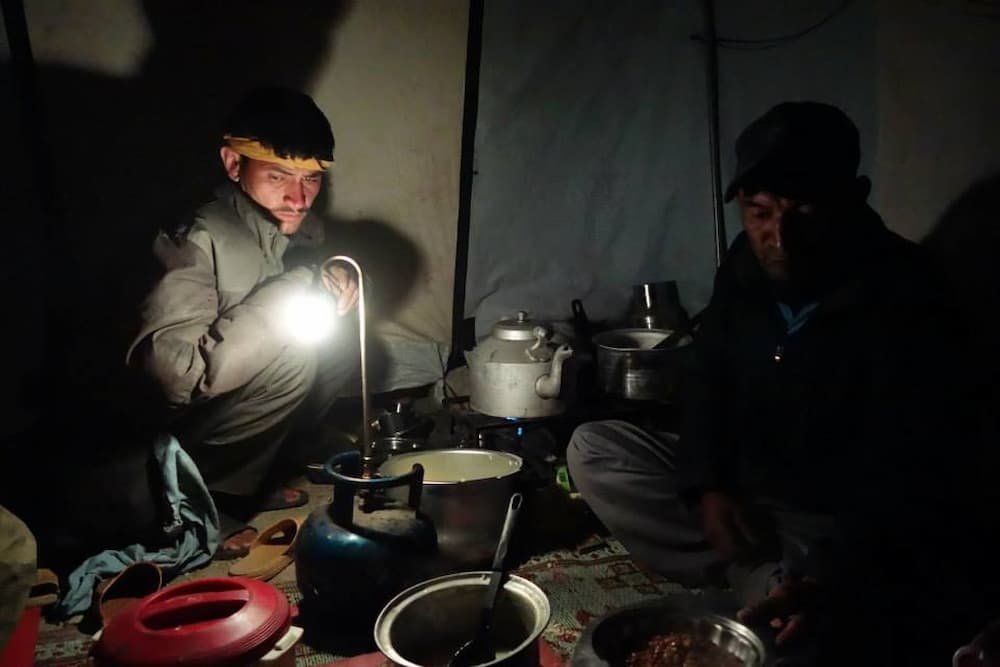
Both of these treks travel deep into very remote territory, and being part of an expedition with tents, food, and cooking equipment for a couple of weeks is mandatory. There are no tea houses to support you like in Nepal. Snow Lake requires a good level of physical fitness with some previous trekking experience plus an adventurous attitude. The weather can be unpredictable at times ranging from very hot days in the beginning to freezing conditions as you get higher up the glacier and cross the Hispar La. Trekkers are however rewarded with some of the most striking scenery imaginable. Here are a few highlights from our trek for inspiration.

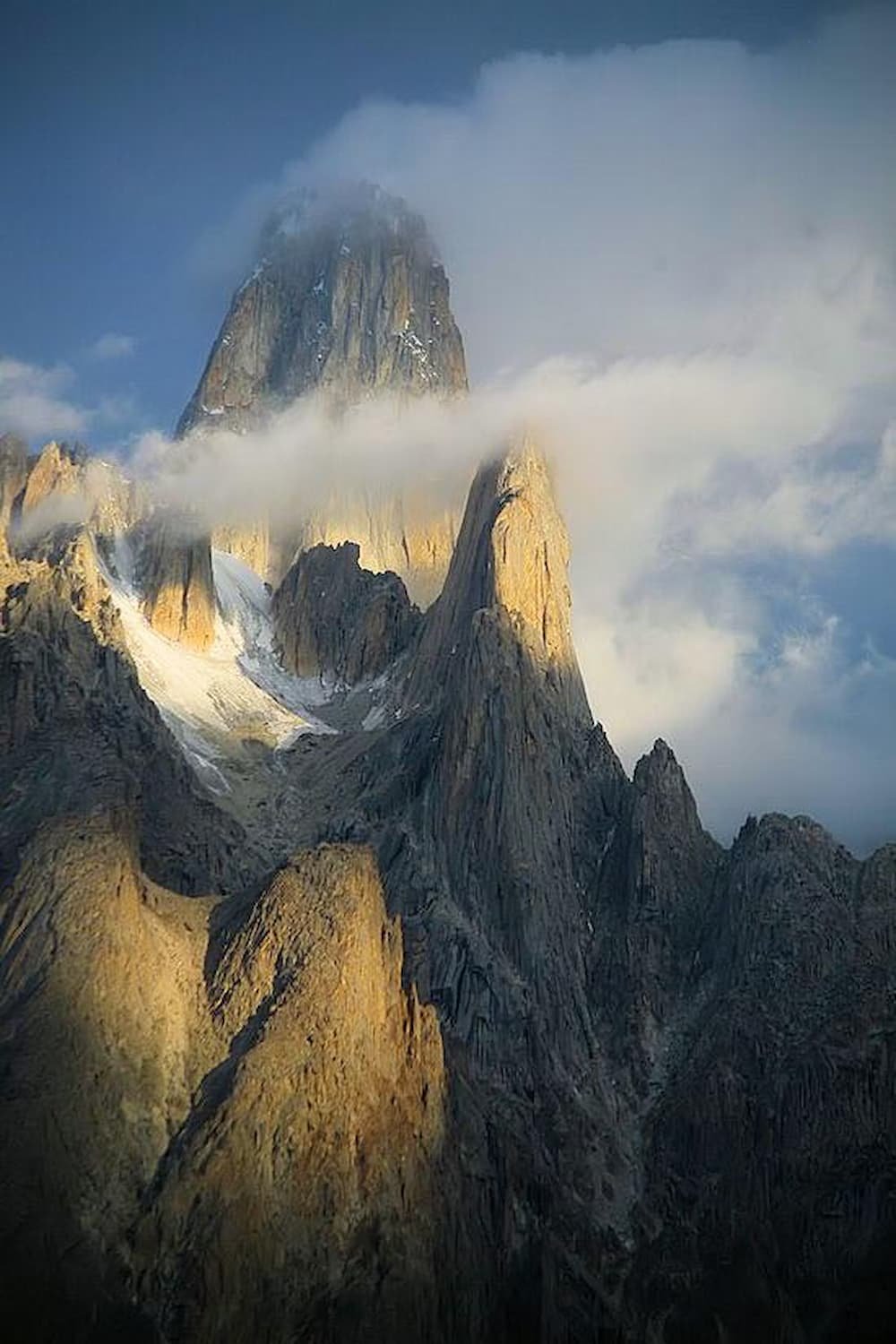
By four in the afternoon the sun disappears behind the towering cliffs. On the far side of the glacier, we are treated to an amazing light display on the stony towers. They bask in golden rays, the light showing off their rough texture.
Don’t. Look. Down!
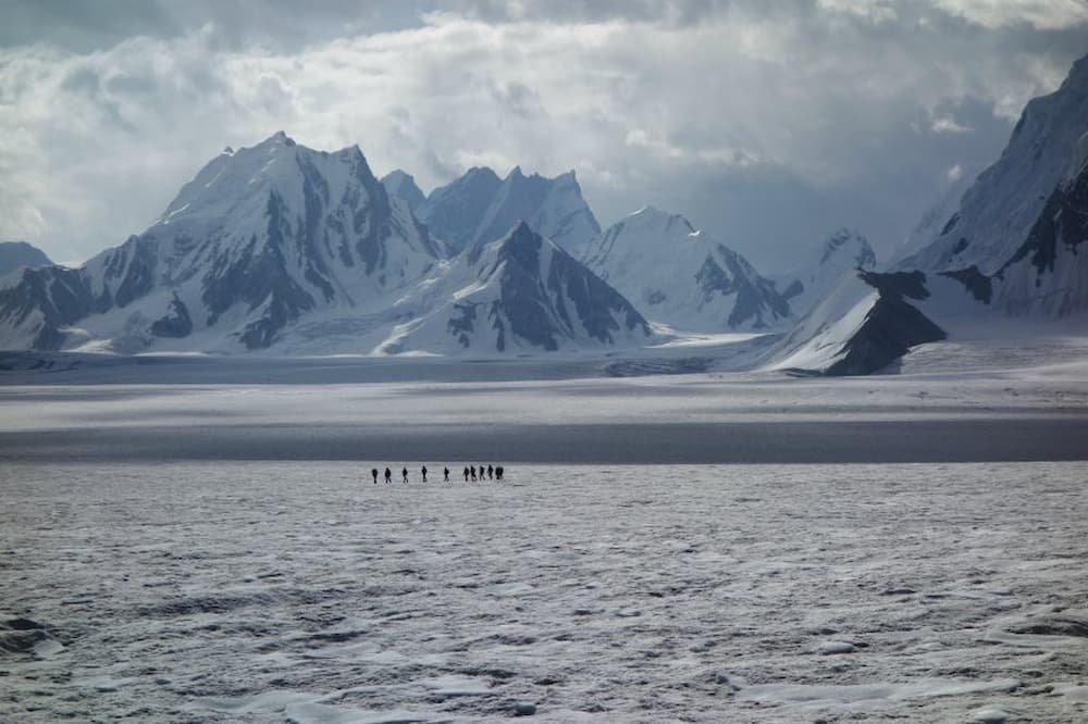
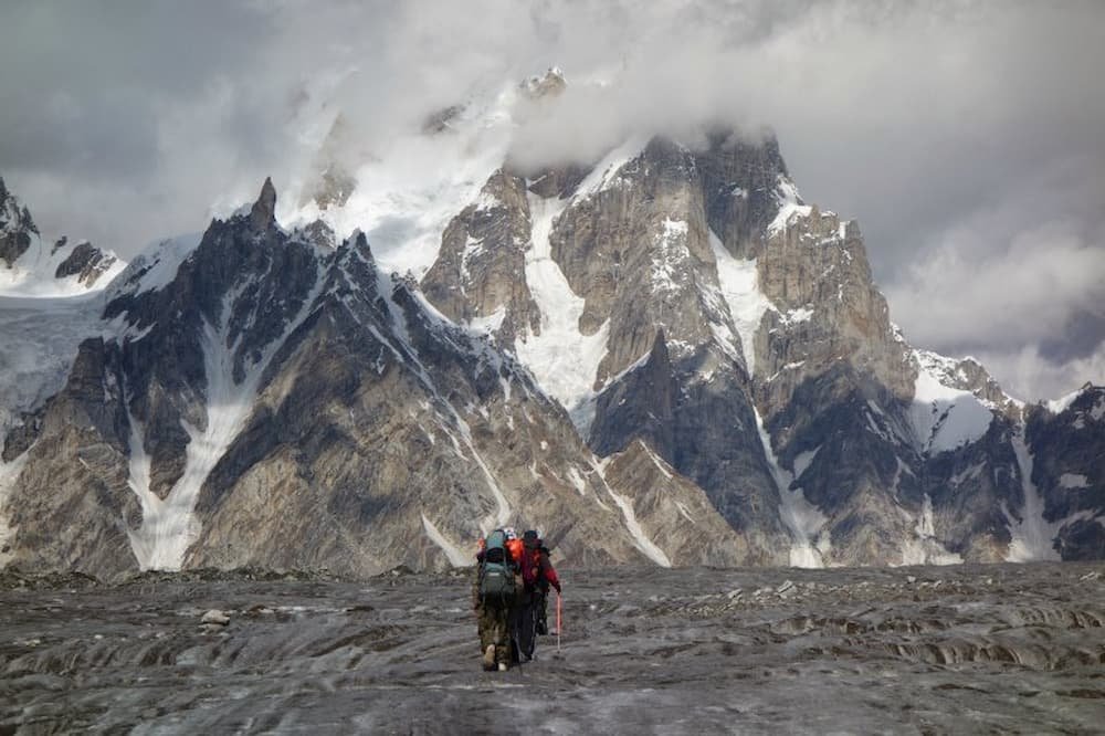
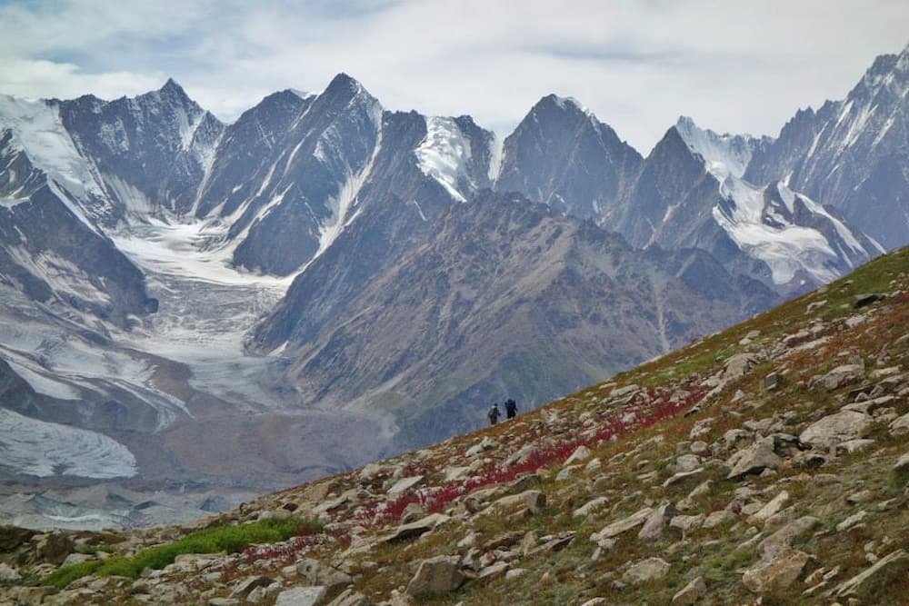
Tiny human figures pale in comparison to the vast enormity of Snow Lake
It’s scenes like this that make you forget how cold and tired you are

The night sky truly lights up
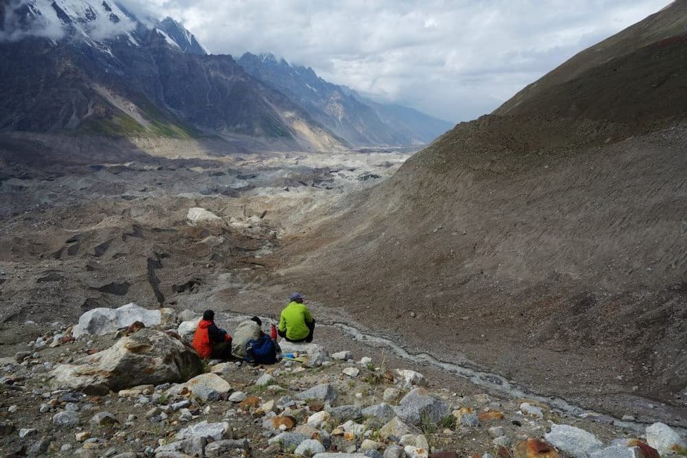
On the 8th day, we come across the confluence of two glaciers. The morning has been difficult already crawling across a series of landslips. Now in front of us, rocks and crevasses stretch for over 2km. It takes your breath away as well as some of your resolve.
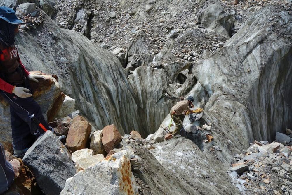
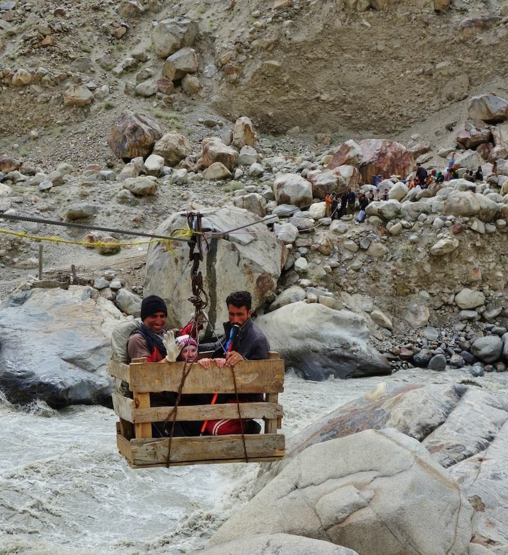
The bridge had been washed out by summer floods so we had to cross the river in a makeshift basket suspended by a cable. Being pulled across by a rope made for a bumpy, yet exhilarating ride.

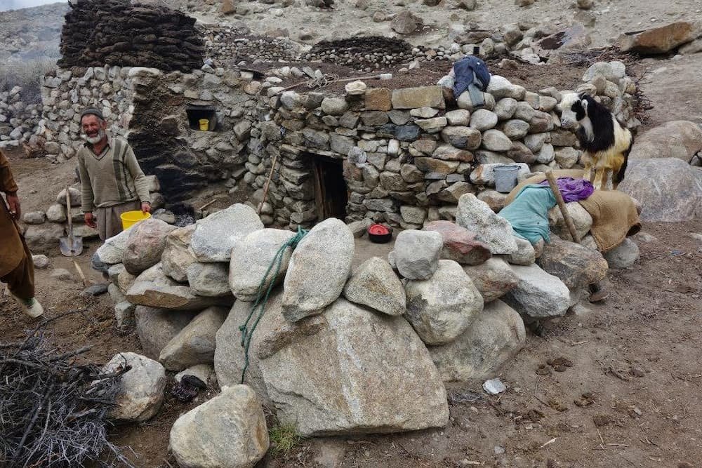
Some extremely impressive architecture going on here. Can you even imagine trying to hoist these massive boulders into place?

A stark contrast between these wildflowers and the rugged mountains
The ten-day Snow Lake trek is an excellent adventure, filled with challenges and spectacular scenery.
Each week we feature a new destination here on Backpacker Travel, in the form of a photo journal. If you are an aspiring photographer who is interested in contributing or have a suggestion for a particular place, please get in touch here.
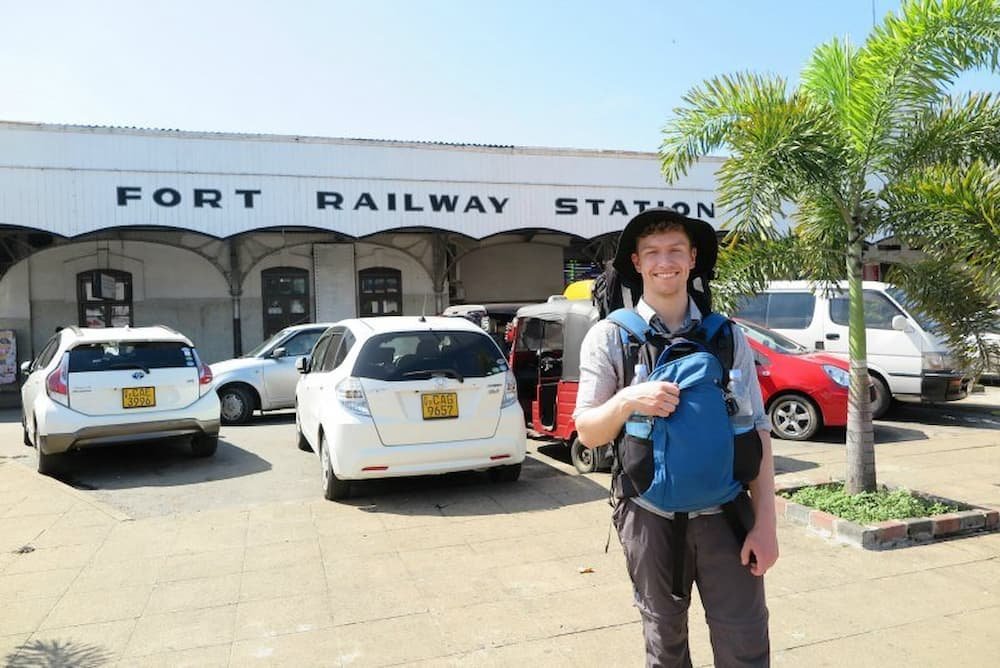
Sri Lanka is a country that took us by surprise! The small island nation is home to a huge variety of landscapes and experiences – you can experience long beaches and palm trees, and a few hours later be in the cool climate of the Hill Country. With temples, national parks, beaches, and cities to choose from, planning your time helps you get the most out of Sri Lanka.

We decided that we had too little time to give everything a reasonable go, so we stuck to exploring the Sri Lankan Hill Country and tea plantations over two weeks. It was incredible and not at all rushed. The trains run through the Hill Country, and also up near the old temples of Polonnaruwa, the famous rock Sigiriya and National Parks, and down the coastline as well. It’s up to you what experience you choose and how much you want to cram into your time.
We felt like two weeks was a good amount of time for our specific journey, but most people recommend a month or three weeks to see all the various regions.
The booking system is difficult to navigate and cannot be done online unless you wish to go with a private train company – which is ExpoRail and the luxury Rajadhani Express. The private train companies will cost you more, and it’s actually just a private carriage attached to the normal train so it is not faster. This is still a viable option for those who want to guarantee a comfortable spot in an air-conditioned carriage and be organized.
If you want to catch a normal train, you must book tickets from one of the railway stations and it is ideal to book a few days in advance to ensure you get a seat. Trains for any route can be booked at a station, so for example, if you are at Colombo Station you can book a train for Kandy to Ella in advance.

The trains are very cheap and provide a lot of beautiful scenery. The prices for our trains were:


Train fares differ depending on the class and length of your journey. It does cost slightly more to reserve your seat ahead of time, but showing up at the station last minute is quite a nightmare as even if you are lucky enough to get a seat, it will be in the very cramped in an unreserved third-class carriage.
We tried every class on the trains and found that second-class offered the best value. It was often a lot cheaper than first-class and it had windows that open so you can take photographs and hang out the windows, whereas first-class had sealed windows due to the air-conditioning. The Second-class is more comfortable than the third-class reserved and significantly more comfortable than the third-class unreserved. The biggest difference in class was between third-class reserved and unreserved.
There do not seem to be any official timetables and fare schedules online, but they can be found in the stations and there are a few blogs with very detailed information about train times around the country.
The train ride is a majestic experience that is more than just a commute. As you wind through the scenery in the old blue trains it feels like something out of an old-school movie. The trains move fast enough to be satisfying but slow enough that you can see Sri Lankan life go past the window in detail.
On the trains between Kandy and Ella, the views are mind-blowing. Hills full of neat rows of tea plantations are dotted with the white bags filled with freshly picked tea, and then soon after there are deep valleys with temples and beautiful villages. The luscious greenery and colorful evidence of human life made this a spectacular journey to remember.

Vendors hop on and off at various stations and offer tea, coffee, and snacks to recharge you on your journey. If you stick your head out the window you will see the train winding around the corners and dozens of others hanging out too. On the trains, there are plenty of interesting people to converse with and exchange valuable travel tips.
Trains are a great way to travel because you are able to move around, socialize, see the scenery and still get to your final destination. In Sri Lanka, trains are a fantastic way to see parts of the country you may not otherwise be able to easily reach. It’s a cheap option and far more comfortable than the buses, and it’s a memorable experience that we would recommend. If you are lucky enough to visit this beautiful and diverse country, you should do it by train.


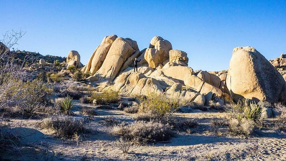
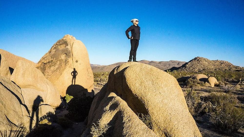
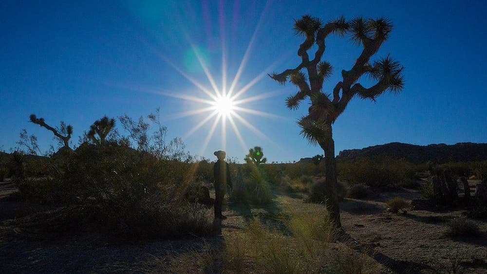
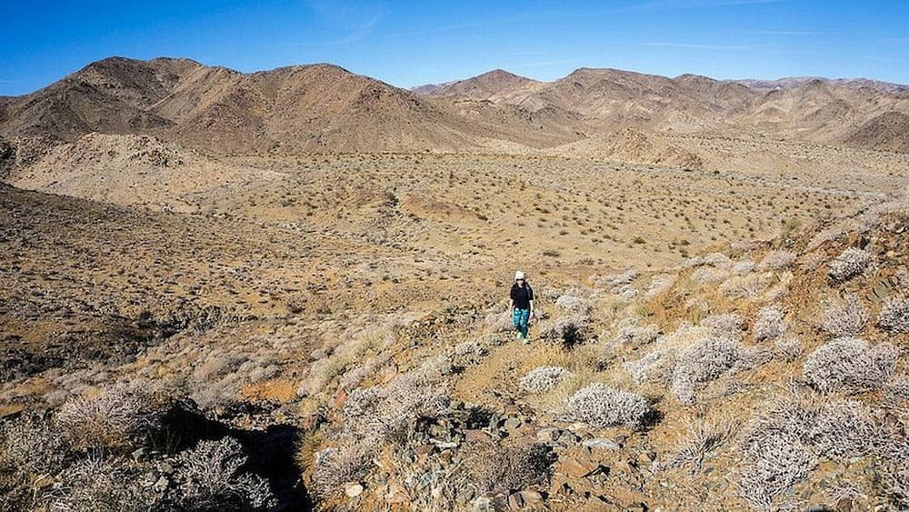
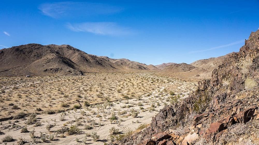
During the recent holidays, we decided to forgo the New Year parties and spend some time away from the crowds. We packed our bags and set off on a road trip from our home in San Francisco down to Joshua Tree National Park in Southern California.
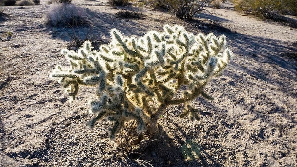
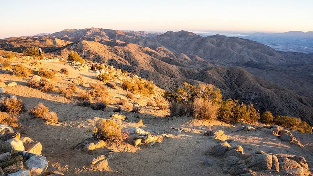
Joshua Tree National Park is located around 140 miles (225 kilometers) to the east of Los Angeles in the middle of the Mojave and Colorado Deserts. This large range of elevation makes for a varied landscape. The higher cooler Mojave, with its scattered Joshua trees and sporadic boulders, has a unique look and feel to it.
If you are into camping, hiking, and rock climbing, this place is epic. There are hundreds of trails and climbing routes for all levels of experience.