continued from Part 2 ….
After a great night's sleep on the side of the road, we woke up to the sound of a National Park Ranger’s car pulling up behind us. The two rangers got out of the car and walked to our side window to check if we were in the van. They asked for our park permit as we had apparently misread the signage and were camping inside the National Park. After a short conversation, they advised us that we had to go and pay for the permit at the Ranger Station and took our details.

We decided that we would go and grab some breakfast first at Coles Bay and after a short drive, we found a nice little cafe near the boat ramp. The lady owner was really nice and told us all about how the cafe nearly burnt down just recently and that her husband was still in the hospital from fighting the fire.
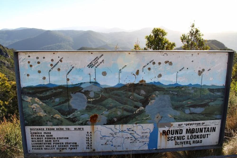
We then went and paid the fine and asked for some details about the best way to go and see Wineglass Bay. It was suggested that we go and check out the lighthouse first as there was hardly any wind in the morning so the best time to check it out. I was surprised to see that there was a disabled access sign as the walkways were very rocky and would be difficult to negotiate in a wheelchair.

The boardwalk wrapped around the coast and the lighthouse and gave some breathtaking views up and down the shore and out to a small island outcrop. We saw a number of different birds and a small lizard before making it back to the van.

Our main reason for wanting to come back to the east coast was to see Wineglass Bay (one of Australia’s best beaches). The walk to the lookout was a few kilometers but more importantly, the surface was rocky and the track was quite steep in parts. After days of freezing cold weather we had been greeted with gorgeous 20 degrees C and blue skies so the trek to the top actually worked up a bit of a sweat believe it or not.

Once at the top we were treated to the most amazing view of Wineglass Bay, the contrast of the white sand and the crystal water made for a great photo as you can see. I wanted to go one further and looked around for a better vantage point by climbing around the rocks and setting up the tripod. The photo wasn’t much better but I felt more adventurous by making the effort.

After we had taken our happy snaps we both decided that the walk up was enough and we decided to come back to the van rather than push on down the other side to the beach since we were both feeling pretty hungry by now.
Lisette had set her sights on sampling some of the famous seafood that Tasmania has to offer for lunch and we had seen a small cafe on our trip into Coles Bay the night before which seemed like a good option.
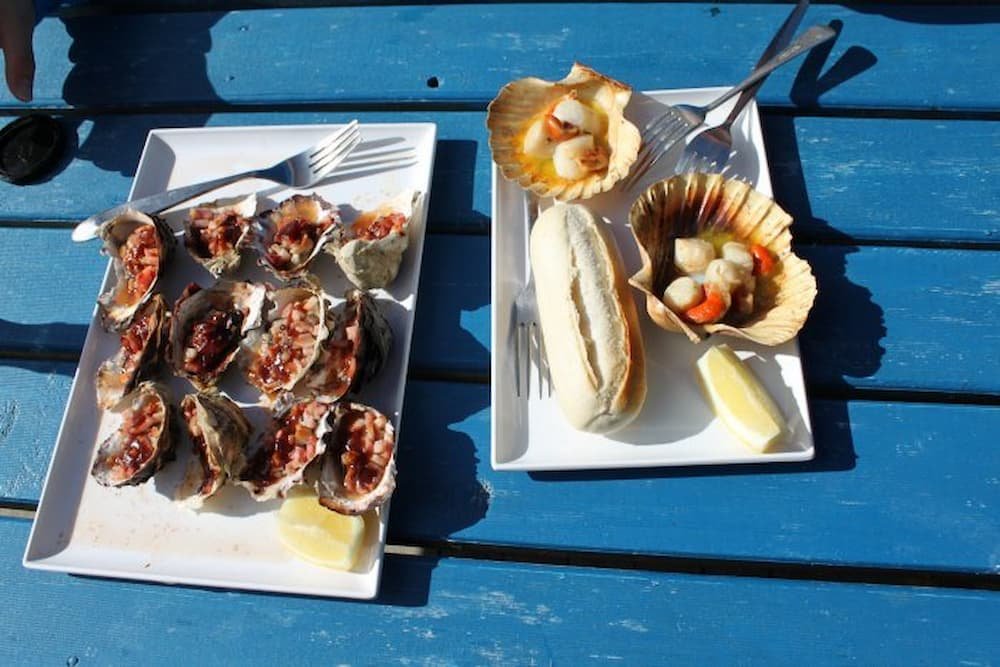
Driving along the main road out of Coles Bay we almost missed the turnoff to the cafe and had to circle back (not an easy task in such a long van). It was worth the effort though…. the most delicious scallops and oysters you could imagine and decent prices too. It was a very simple setup with a small caravan and an outdoor dining deck but that’s all we needed as the food spoke for itself.
It started to get a bit chilly as the wind was blowing onshore which forced us to move on rather than sit and enjoy the sunshine. When I drove in I had to negotiate a small sandy bump and now that we were leaving it seemed that our van was stuck fast in the sand and wouldn’t budge. I moved the van as far forward as possible for the best run-up and revved the life out of it….. Yay! We just made it over the bump and were on our way again off to Bicheno.

The drive north along the east coast was very picturesque and our next stop was the blowhole just north of Bicheno. Here the distinctive orange color on the rocks is from the algae growing in the area giving the rocks a rusty look. There was a small crowd of people watching as the ocean swell vibrated beneath us forcing water up into the air from the blowhole.


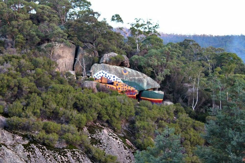
The drive continued up the coast towards the Bay of Fires which was our final stop for the day. On our way, we drove past an interesting rock by the side of the road that was painted to look like a trout.
Arriving at the Bay of Fires just before sunset we watched the orange glow encompass the horizon, a very romantic setting. The time was now approaching 6 pm and we needed to be in Launceston the next day to drop off the van and catch our flight home so I jumped back in the driver's seat and pushed on through the darkness…destination Launceston.
It was a pretty decent drive but a rewarding sight as we came down from the mountains to the city lights… a sight we hadn’t had for some days now. Parking the van we wandered the city streets looking for a bite to eat but hadn’t factored in the Easter holiday closures. The best we could find was a shopping center food court that was only open because of the cinema located next door.
That night we parked the van on the side of the road in a suburban street and set the alarms for the following day's trip home.
The day started at a service station by cleaning out our rubbish and filling the water and petrol tank before dropping the van back at the depot across the road from Launceston airport.
I nearly lost my iPhone by leaving it on the seat where I was checking my emails but luckily for me a young girl had noticed and ran after me to give me the phone before we checked in.
The trip was over and we declared it a great success, vowing to return to the north of Tasmania to check out the towns we missed on this trip.

continued from Part 1….
Woke up around 9 am (early in comparison to the night before) after stopping on the side of the road in Derwent Bridge. Kept on driving – lots of windy roads – the roads were also incredibly mountainous – particularly as we got towards the mining community in Queenstown.
Stopped over for a quick ham/cheese/tomato toastie and coffees (not sure it really provided the caffeine kick we were after, especially as Lisette continued to snooze on the drive-through). The weather in Tasmania, we have found, is incredibly volatile – it can be sunshine and blue clouds one moment, then the clouds will quickly fly through and it will be bucketing not too long afterward.
The latter was the case as we drove through more towns – Hamilton, Strahan… (which on the map look huge but if you are not going on a harbor cruise through the latter, there really wasn’t much point for us to stop there). So we kept on driving through the grey and rain until we got to our destination – Cradle Mountain.
Arriving we found that there were, fortunately, a few spots for us to camp for the night – and that quite a few of our neighbors were roughing it in the rain, with tents to sleep in overnight. Brrrr…

After a quick shower (Lisette had luxury after a couple of days of being stinky with a warm shower and a hairdryer, while Mike could only get boiling-to-the-point of unbearable to I-am-freezing-to-frostbite cold), and some instant Korean noodles (mmmmm….spicy) we wound up in the recreation hall to type out a few stories and watch some DVDs.
Later that night we were feeling quite peckish so decided to venture out in the van to find somewhere to eat. It was now about 8.30 pm and the choice was very limited. We ended up at the Cradle Mountain Lodge as they had a gourmet buffet on that night. It was a little bit expensive but we ate a ton of food… so much so that Lisette felt like throwing up afterward.
After a cold, wet night reaching near sub-zero temperatures, we woke to a clear and more importantly dry day. We set off to the national park center to get the shuttle bus up to Dove Lake where we would start our hike.
A couple of tour buses had arrived at the center just before we got there so we had a long wait for the shuttle. In that time, standing in the cold line, we watched as a tour helicopter took a bunch of tourists on a scenic flight over the park…wishing we were also on it.

On our way out to Dove Lake we watched and listened as the driver made repeated calls on the CB radio to notify the other shuttle drivers of his location. The calls were along the lines of “42 out”, telling the other drivers we were at marker 42 on our way out (this was all due to the narrow road making passing very difficult).
We arrived at our stop and went to register our names in the hiker's log book. The weather was freezing as the wind bounced off the icy lake.

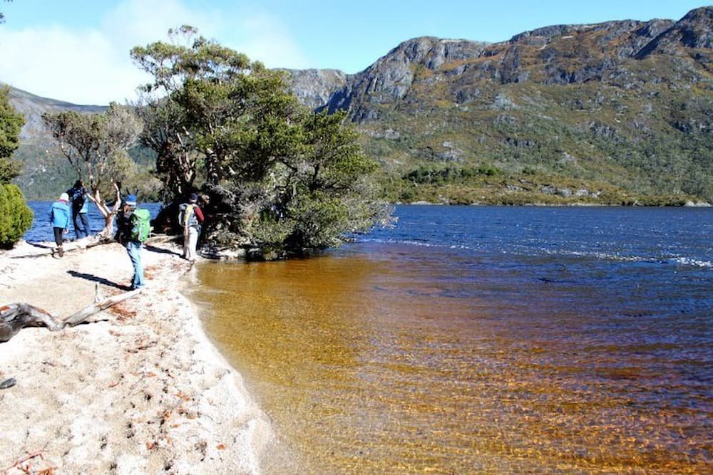
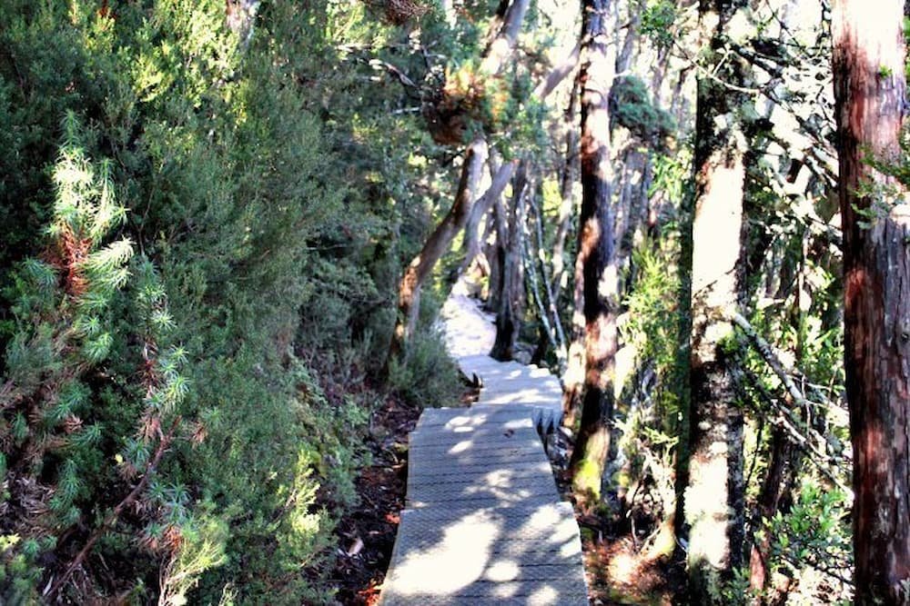
The hike we had decided to do was the Dove Lake Circuit which had fantastic views of Cradle Mountain and the surrounding bushland including a number of waterfalls, a distance of around 6.5kms. The natural landscape was quite rare as this is apparently one of the only cold weather rain forests in the world. We made our way along the well-maintained boardwalks through dense forest covered in thick green moss, past secluded beaches, and rocky outcrops for the next 2 hours.

There was an interesting mix of tourists that we encountered on the walk, from speed walking backpackers, to an asian lady in 4-inch heels (surprisingly she managed to handle the terrain quite well).
Once we got back to the start point and signed off in the logbook we joined the end of the queue and waited for the next shuttle to take us back to the Ranger’s Station so we could begin our long drive towards Bicheno on the east coast of Tasmania.
The drive took us through winding mountain roads and the scenery was great (even though I couldn’t really take it all on while concentrating on the road ahead). We did however stop at a mountain pass for a quick stretch and happy snap.

Our next stop was at The Honey Farm near Mole Creek. We noticed the shopfront as we were driving past and decided to stop for a peek. They had a small museum and gift shop selling every imaginable honey product you could think of. I ended up having a honey ice cream and Lisette looked after the mothers day gifts.

As we drove on our tummies started to rumble and we were craving a good old Aussie burger. Unfortunately, this turned out to be a bad choice as we managed to find the worst burger place in all of Tasmania…. both our burgers were swiftly thrown into the bin as we walked out of the shop.
The road had now started to open up as we headed towards Launceston on the highway so we started to make good time on our way to the coast. As we neared the coast road the sun had just set and the wildlife started to make its way out onto the road again…resulting in an increase in my concentration.
Finally, we arrived at the coast and made our way through Freycinet National Park to Coles Bay where we had decided to spend the night. Once we arrived in Coles Bay we looked for a suitable parking spot so we could get some rest. We decided on a small dirt parking spot by the side of the road just outside the national park entrance.
In our next post you will discover that this spot was not all it was cracked up to be………. read about it here: Around Tasmania in a Campervan – Part 3.
Finally, we are able to spare some time to write about our recent trip around Tasmania over the Easter weekend. We decided that the best way to get around would be in a campervan so we were free and easy. It turned out to be a great plan as you will read in the article as it gave us the opportunity to see some unique creatures in the wild.
In preparation for our morning flight, we set our alarms nice and early and caught a cab to the airport in peak hour traffic. It’s amazing how a simple 20-minute journey can turn into 45 mins in crazy traffic.

We boarded our flight to find out we were sitting at the back of the plane and had a French couple with 2 young girls seated in front of us on our Virgin Blue flight. Let the screaming on takeoff and landing begin…. Now I can typically handle screaming kids but this time was really quite annoying as the mother couldn’t give a shit and didn’t comfort the girls at all.
On our descent, a voice came over the intercom telling us that we couldn’t bring fruit into Tasmania. DOH! We had packed 6 mandarins in our carry-on bag so we had to scoff three each in 20 mins.

We arrived to a cold day and while waiting for our bag at the turnstile a police sniffer dog came and sat down next to me (smelling the mandarins that were previously in my bag), the lady officer asked if I had any fruit and I explained the situation… meanwhile every passenger was starring at me (presuming I was some sort of drug mule) while I went through my bag showing the lady that there was nothing there. How embarrassing!


Picking up our campervan we drove off to Hobart city and to our first stop which was the Cadbury Chocolate Factory. En route we stopped in at a pub and had rissoles and lamb roast for lunch and played a game of keno…$1 we will never get back…
At the Cadbury factory, I managed to get in free after I flashed my travel agent license from 2005. Being Easter we also got given 2 chocolate bunnies. Checked out the gift shop while we waited for our tour. During the tour, the lady explained all about the chocolate-making process and we got free samples of Cherry Ripes and Flakes but still made a few purchases for the trip back at the gift shop before heading off to Hobart again for dinner as it started to rain.

Got to Hobart and checked out the harbor where we saw the old P and O research ship that goes to the Antarctic. Then went to check out the Salamanca area (where they have the Salamanca markets on a Saturday). Shopped for some fresh fruits, cheeses, and stocked up on cereal and milk for the trip.

While taking a photo out the front Lisette was accosted by a guy with a white beard who wanted to know absolutely everything (personal) about us. He was friendly enough but after a few minutes, it seemed to be more of an interrogation so we did our best to lose him.

Drove around Battery Point and looked at all the old houses and shops, then we drove to Wrest Point and went for dinner at the casino bistro. The all-you-can-eat buffet was more expensive than we were willing to pay for and we weren’t that hungry so went to one of the other restaurants instead.
I had the Thai chicken salad with hokkien noodles and Lisette had the smoked salmon ceasar salad (mine was the winner on the night).
Got back to a cold car and decided to drive through the night to Port Arthur where we would camp out at a car parking area until the morning.
Woke up to many cars and campervans driving past us – after a freezing night (with Lisette practically suffocating the claustrophobic Michael), it turned out that we had slept till 10 am or so!
We walked down to Port Arthur entrance – they close late as they do ghost tours as well. The cheapest ticket you can buy to get in costs $30 (bronze pass), which gives you access to the area, a guided 30-minute tour, and a 20-minute harbor cruise. You also get playing cards where you can ‘be’ a prisoner and find out about the convict’s life.

Really informative and educational tour about Port Arthur and its convict history – can see how you can easily spend a whole day wandering the 90 acres or so. Over the 47 years that it was in operation it had about 7,000 prisoners walk through and toil on its grounds, with about 1,100 dying and being buried on Death Island across the water. Besides the various penitentiaries and housing for the governors and soldiers, you can find a couple of museums, a shell of a church, and another Anglican one on site.
We went on the harbor cruise first and found out that it was really hard to escape – you could try swimming (someone tried to make a boat out of a beached whale’s carcass), but it was all but impossible to leave.
Unfortunately, when it came to our guided tour it bucketed down with rain and our group was standing under a tree looking fairly miserable as the wind blew more rain in our direction. Our pleasant tour guide tried to make the most of a dismal situation, by cracking jokes (not sure if it was more for his sake though).

Port Arthur was really revolutionary for its time as it was not just a place of punishment – it was aiming to provide reform for the men. In some cases, it did succeed. When the prison shut down it was renamed as Carnarvon for a while with the aim of being a place people could live, but so many tourists (and honeymooners) wanted to visit it for its prisoner history that soon after it reverted to its old name, with many convicts taking tourists around.

We then went straight to the Tasmanian Devil Sanctuary which housed not only 30-odd devils but also a menagerie of birds (tawny frogmouth, rosellas, parrots, peregrine falcon, etc), as well as quolls, wallabies, and kangaroos.

We made it in time to see the devils being fed (scavenging around as they do by nature and attacking each other for the pieces of meat), as well as seeing a bird show, trooping after wallabies and kangaroos (but staying a while away from the geese).
Sadly there are not many devils left in the wild – many are being killed off by a mysterious cancer that is spread from one devil to another when mating or biting each other when playing. The devils that are in the sanctuary are cancer-free. Interestingly their life span is only 5-6 years and while the mum can have up to 15 in a litter, she can only raise 3-4 at a time.


Starving we then went to have lunch at Eaglehawk Neck (named Doo Town) – fisherman’s cone! With battered fish, scallops, calamari rings, and lots of chips. Checked out the blowhole (which was barely blowing) and then up to Fossil Point where lo and behold – there was a pair of orcas swimming around!! Yay – took some awesome shots.


Then came the long drive towards Strahan – the wildlife spotting continued, with a couple of wild Tasmanian Devils, lots of scampering wallabies, mice, and possums – and unfortunately lots of roadkill. Luckily we weren’t the cause of the roadkill (although there were a couple of very close calls). This was all through the night – as they are nocturnal animals we were very fortunate to encounter them, although the road was incredibly windy so you definitely need to be a confident (and not a fatigued) driver to navigate, particularly as the road is not well lit (high beams beaming!)
I decided that I had driven enough for the day and we stopped by the side of the road at Derwent Bridge to sleep for the night. In our next post, we head to Cradle Mountain. Read it here: Around Tasmania in a Campervan – Part 2.
Located in heart of West Africa, Burkina Faso is the sort of place that captures the imagination – how many of you even knew that Burkina Faso exists? This may be one of the world’s poorest countries, but it’s also one of the most stable in the region and runs with an efficiency that’s the envy of many of its neighbors.

Burkina Faso has a primarily tropical climate with two very distinct seasons. The rainy season and the dry season where the harmattan (a hot dry wind from the Sahara) blows. The rainy season lasts approximately four months from June to September and is shorter in the north of the country.

The cuisine of Burkina Faso, typical of West African cuisine, is based around staple foods of sorghum, millet, rice, maize, peanuts, potatoes, beans, yams, and okra. The most common sources of protein are chicken, chicken eggs and freshwater fish. A typical Burkinabe beverage is Banji or Palm Wine, which is fermented palm sap, and Zoom-kom. Especially the town of Banfora is known for its good quality Banji, though one should be wary of the Banji sold by hawkers as it is often not very fresh and may contain added water.

Visitors in June and July must try the caterpillars known as “chenilles”. The caterpillars come fried and can be eaten crunchy like french fries or put in a baguette as a sandwich.
Two key elements of culture in Burkina Faso are its indigenous masks and dancing. The masks used in this region of the western Sahel are made for rites of sacrifice to gods and animal spirits in the villages. Native dance, on the other hand, is employed to demonstrate the villagers’ desire for blessings by the spirits.
The cinema of Burkina Faso is an important part of West African and African film industry. Burkina’s contribution to African cinema started with the establishment of the film festival FESPACO (Festival Panafrican du Cinema et de la Televison de Ouagadougou.
The West African Franc (CFA)
As with many West African countries the main global language is French. Other local languages include: More, Fulfulde, and Lobi.
Bobo, as it’s widely known, may be Burkina Faso’s second-largest city, but it has a small-town charm and its quiet tree-lined streets exude a languid, semitropical atmosphere that makes it a favorite rest stop for travelers. It has a thriving market, a fine mosque, and a small popular quarter, Kibidwe, which is fascinating to roam around. There’s also a lively music scene.

The beautiful Grande Mosque, in the old part of town, is a good example of Sudanese mud-brick architecture with its towers and wooden struts. The best time to visit is at sunset when the facade turns a golden color and the locals pass by pausing for prayer. Le Grande Marche is a huge, colorful market that offers just about everything you need to live in Burkina Faso. From cloth to plastic buckets and jewelry to gas lamps as well as a selection of fruits and vegetables, the market is great for picking up souvenirs.
The modern Cine Sanyon is an excellent cinema that shows good films, including runs and reruns of Burkinabe productions which have won international acclaim, as well as dated Hollywood blockbusters and Jackie Chan flicks.

Most travelers end up liking Ouaga (as locals call it). While it could just be that the city’s name rolls off the tongue in a wonderfully rhythmical African way, there’s no mistaking the fact that, for the capital of the world’s third poorest country, Ouagadougou is surprisingly upbeat, friendly, and home to good hotels, restaurants, and nightspots.
The gateway to the Parc National des Deux Bales where the elephants roam, is the sleepy town Boromo in Southern Burkina Faso.
A few weeks ago Lisette was scanning through the daily group buying deals to see if there was anything interesting when she came across a 2-for-1 deal on Cudo. It was for a 4 hour Middle Harbour Eco Tour with Sydney Harbour Kayaks (a big change from the normal health and beauty or restaurant offers).
Well, last weekend we had the pleasure of taking the tour…. and boy did it live up to expectations!
The morning started at 8.30 am with a comprehensive briefing on safety and how to paddle correctly in a kayak. It’s actually quite interesting how much of a difference a little technique can make in both speed and performance but more importantly in how sore you feel the next day.

We had gone canoeing over the Christmas break in Jervis Bay and I can tell you that my technique must have been horrible as I was in pain for days after.
The obligatory ‘name and shame’ of the group followed when our guide made us introduce ourselves and say where we had heard about the tour. Needless to say, EVERYONE had purchased it through Cudo. Shameless promotion I know but you have to admit that these group-buying sites are powerful. In fact, our tour guide (Sol) explained that they had 2,500 people purchase the coupons and were subsequently booked solid.

After a quick setup of our rudder, we were in the water. We started by paddling out and across the harbor from the Spit Marina and I guess I mustn’t have been listening in the briefing as my arms were already sore. Luckily for us, the weather was perfect though, zero wind, gorgeous blue sky, and about 28 degrees.
Paddling under the Spit Bridge we were surrounded by mega luxury yachts and cruisers on one side and multi-million dollar waterfront houses on the other. In fact, one of the houses was designed by the famous architect Jorn Utzon who is responsible for the iconic Sydney Opera House.

We continued around a few bays making sure that the group stayed relatively bunched and hugging the shoreline for safety. It was amazing to see how much isolated parkland there was considering we were still smack–bang in the middle of Sydney. In fact, Sol pointed out that the geographic center of Sydney was up a small tributary not far from where we were.
I was now starting to have a few issues with my butt and left leg going numb. I guess it was because our rudder was a little off-center and I was constantly battling it to stay on track. About 1 hour 45 mins into the paddle I was praying for a break and luckily for me it wasn’t too far off.
When we hit the halfway point we paddled across the bay to a beautiful little beach landing that was very secluded. We had a bit of an explore while Sol set up the picnic for morning tea. By this time both Lisette and I were famished so we happily devoured the cheese and crackers, Tim Tams, and sliced watermelon washing it down with a cup of coffee.

Once we had let our food settle a bit and had a good chat with some of the other group members we were off again. Making our way around the next point Sol explained some of the history of the area. There were some old buildings to our left that were used as ‘powder houses’. These fortified buildings were used to store the explosives for commercial demolition back in the day. There was a big sign warning not to dock….we didn’t want to take our chances.
Knowing that we were now on our paddle back I was amazed at the transformation of how I felt. I started to get a good rhythm and the pain had gone away which made the paddle so much more pleasant.

Just before we made it back to the marina we came across a young family with 3 children paddling in a canoe. The kids were so excited to see our group and yelled out to challenge us to a race. It was on! I have to let you know that both myself and Lisette are rather competitive people and we didn’t want to go down so we paddled like there was no tomorrow. There was yelling back and forth “we are winning…no we are winning” and in the end, it was too close to call.
The last stretch of water and a headwind had picked up which made us really work hard to get home. Finally, we made it back and said our goodbyes before grabbing our stuff and heading home. It was a great morning out on the water and I would definitely recommend the experience if you have time.
Mauritius is a hidden gem in the Indian Ocean that will enchant and amaze you. Every encounter is an opportunity to discover a friendly face. With the contrast of a multitude of colors and tastes, the island, set in its turquoise sea, is an oasis of peace and tranquility. Mauritius is a melting pot where past and present are smoothly blended together, offering a beauty that will compel you to return to its shores time and time again.

Being in the southern hemisphere Mauritius has its summer months from December to February and its winter from June to August. The temperature in the coastal areas varies between 22C in winter and 34C in summer. The sea temperature ranges between 22C and 27C. The eastern side of the island is prone to strong winds and therefore it is frequented by windsurfers and kite-surfers.
The cuisine of Mauritius is a blend of Indian, African, Chinese, and European influences. It is common for a combination of cuisines to form part of the same meal.
And if you have certain dietary requirements, you can even shop for organic food through established online grocery stores. This should give you plenty of options during your stay.
Mauritius is a blend of diverse cultures and religions. The population of over 1.5 million consists of Hindus, Creole, Chinese, Muslims, and Europeans.
The monetary unit is the Mauritian Rupee (Rs.) which is divided into 100 cents (cs)
The Mauritian economy is based on four sectors: Textile, Tourism, Sugar, and Services
Most people in Mauritius are bilingual and are equally fluent in English and French. Creole and French are the main languages in the everyday environment and several oriental languages are also spoken.
Grand Bay was the first area of the island to fully experience the tourist boom. A shopping and leisure paradise, Grand Bay also happens to be the area where Mauritians head when they want a fun-filled night out (restaurants, bars, and discos). You can also find many dive centers if you are wanting to explore the life below the ocean. I actually did my very first scuba dive out of Grand Bay.

The longest village on the island, Triolet offers an opportunity to visit the biggest Hindu temple, the Maheswarnath.
Flacq is one of the most important villages in Mauritius. It is a meeting point for the people of the East that boasts the country’s largest open-air market. This extremely colorful market attracts a large number of people.
Ile aux Cerfs is a paradise for water sports and has the most beautiful beach in Mauritius. You cannot afford to miss this tiny island, delicately poised on the ocean, a real pearl in the Mauritian landscape.

Owing to the remarkable work accomplished by the Mauritius Wildlife Fund, the island has become an international standard for the protection of natural resources and endangered species. A few of the world’s rarest birds, including the kestrel, can be seen there. You can also discover the extremely rare Pink Pigeon, the Green Gecko Phelsuma, and the Aldabra giant tortoise.
Did you know? Mauritius was the only known habitat of the extinct dodo bird.
Home to splendid hunting grounds covering an area of 900 hectares. Stags, monkeys and boars live amidst the vegetation of the hillside. You can watch a few species of endangered birds, including the kestrel. The Domaine contains four thatched-roof bungalows and a restaurant with a panoramic sea view. Take an opportunity to enjoy a delicious meal of venison and seafood. Yemen reserve is another smaller game park.
A winding road leads from Case Noyale village to the colored earth of Chamarel (an undulating landscape of different and contrasting shades of colors). The different shades of blue, green, red and yellow are apparently the result of the erosion of the volcanic ash. The neighboring waterfalls of Chamarel rise from the moors and the native plant life. The site possesses a rare beauty

This national park of 6,574 hectares was created in 1994 for the protection of Mauritius’ remaining native forests. Enjoy magnificent landscapes, with endemic plants and rare bird species.
Beyond La Marie and Mare-aux-Vacoas we find one of the two natural lakes of Mauritius. It rests within the crater of an extinct volcano. Ganga Talao is an important pilgrimage site and many Mauritians of the Hindu faith walk there during the Maha Shivaratri festival or the night fasting dedicated to Shiva.

Situated in the Riviere Noire district, the bird park stretches over 25 hectares and contains more than 140 bird species from all five continents. Other attractions include fish ponds, tigers, tortoises, monkeys, deer, and orchids.
A district of Mauritius in the north of the island, and is one of the most densely populated parts of the island. The name of the district comes from the French word for grapefruits.
It hosts the SSR botanical garden, or Jardin Botanique Sir Seewoosagur Ramgoolam, renamed in 1988 in honor of the first prime minister of Mauritius.

So, why not check out Mauritius as your next holiday destination, it offers fantastic accommodation ranging from budget resorts to pure 5-star luxury. You can shop till you drop, dive all day long, explore the wilderness or just relax and pamper yourself.
Mention the North Yungas Road to most people and you probably won’t get much of a reaction, that is until you explain that this infamous 70km stretch of asphalt and dirt is commonly known as the Most Dangerous Road in the World or ‘Death Road’.
From an altitude of over 4,500 meters in La Paz, it winds its way precariously through the Amazon to the town of Coroico some 3,000+ meters below.
This might not sound too bad until you add in other factors like fog, rain, and dust, reducing visibility in some areas to just a few meters. Throw in the extreme drop-offs which can exceed 600 meters in some places, no guard rails, uneven road surfaces with a width of just 3 meters and you have a recipe for disaster.

It has seen the deaths of some 200-300 people annually and is attributed to one of Bolivia’s worst road disasters where a bus toppled off the side killing more than 100 passengers.
Ironically the danger of the road has drawn thrill-seekers from around the globe. Thousands of mountain biking enthusiasts flock to Bolivia to take on the Death Road each year and this has tragically resulted in a number of tourist deaths. One of these incidents occurred on the 9th of May 2004 and you can read more about the tragic event at www.liebreich.com.
Our friend Scott MacKinnon recently experienced this thrill ride for himself and we have featured his crazy video below. If you would like to take on the ride of your life then you can check out Gravity Bolivia.
Thanks once again to Scott for sharing his video and we pray for the safety of anyone wishing to try out this adventure for themselves. Here are some amazing pictures taken from Flickr under creative commons.


After playing tiger hide and seek at Ranthambore, our next stop was Jaipur. Known as the “Pink City”, it’s the capital and largest city in the state of Rajasthan. The city was founded by royalty (Maharaja Sawai Jai Singh) in the 18th century, with the royal family still living there today.
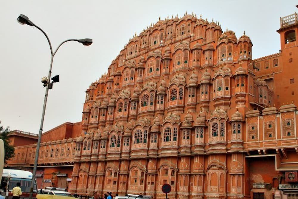
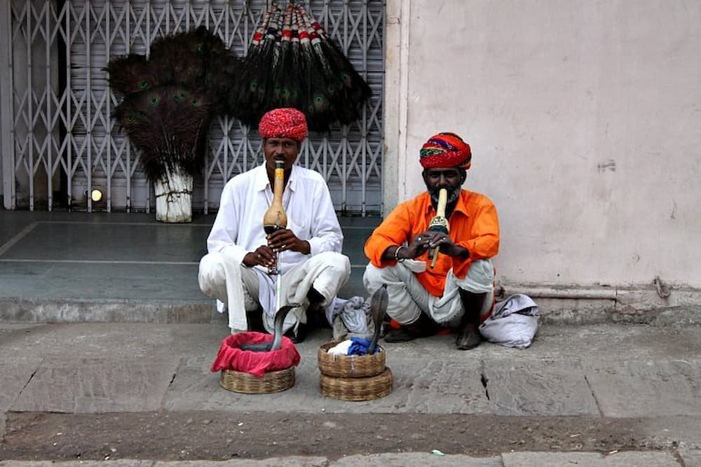
The day started by taking a photo of the iconic facade of the Hama Mahal (Palace of the Winds) and from looking at it, it is clear why Jaipur got its nickname as the Pink City. Sprinting across traffic to take some snaps, we also managed to spot (much to our delight) a couple of snake charmers across the road from the Palace the first time we’d seen any on our trip.
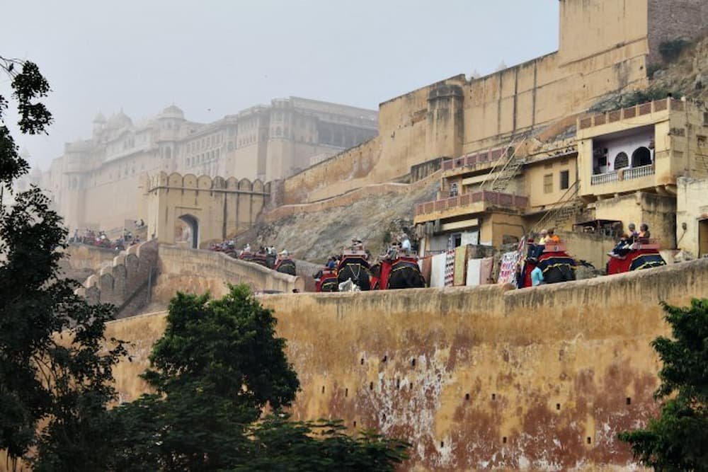
We then sped over to Amber Fort for our elephant ride to get there. We rushed over there to avoid the queues, however, while the line seemed quite long we did get to the front fairly quickly. There are about 120 elephants that make the trek each morning to bring tourists to the top of the hill these elephants need to make five trips up and down in the morning and then their day’s work is done, so if you get there in the afternoon you will miss out on the elephant ride (as a result, our queue was packed with foreign tourists – Indians tend to drive/walk up the slope instead).

While waiting, we were confronted with at least a dozen hawkers who were peddling everything from camera memory cards and snake charmer-style hats to wooden statues of Ganesha and t-shirts printed with Indian tourist attractions.
If you’re absolutely not interested in buying don’t entertain these guys as they will pester you incessantly, but if you’re thinking of making a purchase you can bargain hard for a better deal.
Finally making it to the front of the line, we clambered onto our elephant, up the slope towards the Fort. It’s definitely a fun (if not rocky) experience and takes about 10-15 minutes in total.
Once we disembarked there was a sign that clearly said in big letters “no tipping”, however, our elephant driver actually hung around at the top looking for us until we passed him up a tip, despite the fact that Amber Fort churns through as many elephant rides in the morning as possible. As soon as we passed him the tip though, he couldn’t leave fast enough!

The Fort itself was breathtakingly beautiful. From just behind the entrance, the ladies of the harem could see out from inside, however, people standing outside couldn’t see them. One of the Mughal emperors who lived in Amber Fort had 12 wives and a harem of 364 women – when he arrived back at the Fort from a trip, there was a gap through the screens where his ladies could throw rose petals at him.
Inside, the Fort had lots of intricate designs on the walls and ceilings, including colored carvings inlaid with semi-precious stones such as rubies and emeralds (just like the Taj Mahal), as well as paintings of camels, tigers and scenes from the Kama Sutra.
There was also a winter and summer palace that faced each other with gorgeous gardens in between and a stream in between to keep people cool on steamy summer days. Other amazing features were the Turkish baths, a serenely white Hindu temple, as well as the Hall of Mirrors, which is exactly what it sounds like – hundreds of mirrors on the ceiling and walls that had silver frames around them.


After leaving the Fort and taking some photos of the Palace on the Lake, we headed over to Jantar Mantar – basically a big outdoor astronomy center, which houses over half a dozen devices that were built in the last several centuries to measure time, celestial bodies like the sun, as well as Zodiac signs.
The main attractions were two massive contraptions – one sundial which could tell time accurately to within twenty seconds, as well as a bigger version that was precise to two seconds. Standing under the hot midday sun, we cooled off afterward by buying milky Indian ice cream (kulfi)from a street vendor just outside Jantar Mantar.


Next was the City Palace and Museum, which gave us a glimpse into the history and lives of the Maharajas over the centuries. Here you could see the Maharaja and Rani’s (his wife’s) outfits, check out the hall where the royal family met with foreign dignitaries, as well as spot the two largest silver objects in the world (they’re in the Guinness Book of Records).
These are two large silver urns that weigh 364 kilograms, in which one Maharaja used to fill with water from the Ganges River when he was traveling, to ensure that he could bathe and drink this holy water even while he was away.

The royal family lives just behind the Museum – the current Maharaja is 70 years old and has three grandchildren, with his daughter’s eldest son next in line for the throne. Two flags upon their home indicate that the family is at home, while one means that they are out.
No photography is allowed inside the royal family’s house, however, if you are interested in looking inside the Palace, no photography is allowed and it costs Indian Rupee 2,500 to try and arrange a visit.


Our final stop on the tour was a handicraft/textile store to see how materials are dyed. Jaipur is well known for its thriving textile industry, and it was amazing to see a demonstration of how the process worked.
A man showed us a plain white cotton cloth and had four stamps which he stamped one after the other in different colors, to create a picture of a bejeweled Indian elephant. As soon as this was done the cloth was submerged in water – and magically, the colors didn’t wash out at all.

Driving through Old Jaipur again afterward, we passed dozens of stores selling fruit/vegetables and piles of textiles, as well as, of course (it wasn’t so strange anymore to see this), numerous cows and camels hanging around and strolling through the streets.
Starving, we decided to have lunch at Mcdonalds. Yes, you read right – while I don’t really eat it back home, we were curious to see what would be on the menu given that cows would not be an option. The substitute for the Big Mac was the Chicken Maharaja burger – it had two slices of chicken patty with lettuce, tomato, and cheese, as well as a spicy, yummy sauce.

Walking back to our hotel, the walk was a mere 15 minutes long but traffic was so noisy and chaotic that you wouldn’t want to walk around for more than 30, as it’s quite deafening.
Stay tuned for our next (and final) post on Jaipur at night – including the heart-stopping taxi ride the evening before, doing business in India and partying it up with the best of Indian culture – think banquet feasts, Bollywood-style dancing, elephant rides, and henna!
After enjoying the beauty of Agra, the next stop for us was Ranthambore, where we would be spending the next two days on the hunt for the elusive Indian tiger on several safaris.
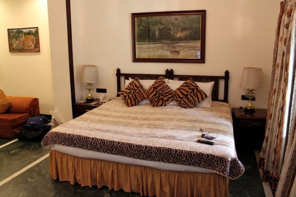
We decided to splurge on our accommodation for the next couple of nights was one of the best on our trip – Vivanta by Taj, a five-star villa. Our room was massive – a king-sized bed with a safari tapestry hanging on the wall above, tiger-striped cushions and a huge marble bathroom that included a spa. It was so big that we had two air-conditioning units as well – definitely nice and plush!
In keeping with the safari theme, the hotel had a couple of stuffed wildcats – a tiger hung above the pool room while a leopard was encased in glass next to the reception area.
That evening, we were treated to a dinner fit for any Maharaja – an outdoor buffet dinner with lots of Indian dishes including daal and curries. Fresh naan bread was being made by two ladies clad in colorful saris, while dessert was the round, syrupy sweet gulab jamun and vanilla ice cream. To add to the ambiance, we had a family playing music, singing, and dancing, while clear bowls filled with rose petals floating in water and candles topped everything off.


The next morning, we woke up before dawn (yep, even before the crack of dawn was up), to get on our 6.30 am safari. We were on a canter for all three safaris over the next two days – basically they look like big buses with the roofs cut off. It was freezing though – the dew overnight meant that the seats were wet on the canter, but luckily we were provided with blankets to sit on and wrap around ourselves as the chilly wind whizzed past us.

After picking up a few more tourists, we were on our way to Ranthambore National Park. One of the biggest and most popular national parks in northern India, the chief attraction is the tiger, which is now endangered thanks to the site being a former hunting ground for the British and the Maharaja.
The park is crammed with other amazing flora and fauna that would enthrall any nature lover though – you can see massive trees (palm, gum and the second-largest banyan tree in India), marsh reeds, flat plains, and rising cliffs. There are also scores of birds (kingfishers, vultures, buzzards, snake birds/Indian darters, peacocks, and partridges), two types of deer (spotted and sambar), cheeky monkeys, and crocodiles (we saw one swimming in Padam Lake, one of the three lakes in the Park).
We didn’t have to wait long to see wildlife in action either – as soon as we drove in we saw an eagle swoop down at lightning speed to poach a rodent. David Attenborough would have a field day doing commentary in this place!


The terrain was incredibly bumpy to navigate around – we marveled at the skills of our driver, who seemed unfazed in backing up and down the essentially one-way road (heaven forbid what would happen should we cross paths with another canter – I think it would be a bit of a standoff to see who would back down first!).

We had our third and final safari at dawn the next morning. On this trip, we were the closest to spotting a tiger – it had rained in the morning so we spotted fresh tracks on the road, apparently trailing a bird.
Unfortunately, we didn’t see it in action, but over the three safaris highlights included gazing at a crossing of over 20 spotted stag and deer, watching a family of monkeys casually munching on berries in a tree (and getting up to some naughty monkey business), as well as several huge birds perched atop branches, pondering their next move.
Our tip for anyone interested in going for an Indian safari? If you can, try and score seats in the jeeps instead – they are smaller, less noisy and can drive further into the dense terrain – so you do increase your chances of seeing tigers and other animals that typically wouldn’t make their way down to the tracks.
With all the noise our canter was omitting, I wouldn’t have been surprised if we had scared the tigers away. If you don’t manage to hitch a ride in a jeep and opt for the canter, definitely aim to get seats right up the front looking out the windscreen.


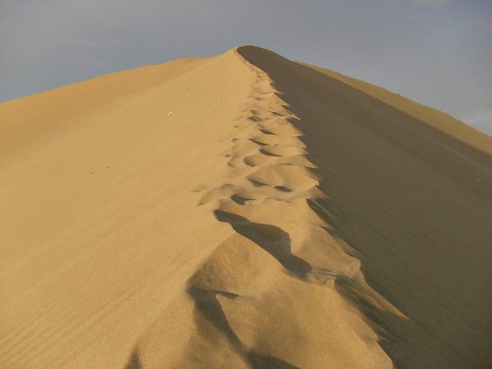
48 hrs from Montanita I found myself in the desert oasis of Huacachina. It was a long time coming but I had been longing to get here ever since I laid eyes on its beauty in a picture I had randomly stumbled on years ago. When I say desert oasis, I truly mean it…
Huacachina is a small town of about two hundred people nestled between mountainous golden sand dunes, situated around a tranquil lagoon. There is only one road in and even it seemingly disappears into the sand once you cross the threshold and step foot on the waterside boardwalk.

My ultimate goal here was to try my hand at sandboarding but I found myself overcome by the sheer beauty and magnitude of my surroundings. Suddenly screaming down the sand at breakneck speeds wasn’t all that big of a concern.
From the moment our dune buggy broke the crest of that first hill of sand and the vast desert landscape came into focus, I was in absolute awe. It’s hard to comprehend that billions upon billions upon billions of tiny grains of sand can come together in such as display of constantly changing harmony, but there it was in front of me in all its glory.

From my feet to the horizon in every direction was nothing but sand. If it wasn’t for the roar of the dozen or so buggies whipping travelers up and down the slopes, it would have been all too easy to lose yourself in the silence for hours on end. Speaking of the dune buggies, they were an adventure all to themselves.
Built for nothing else but tackling these sand giants and consisting of little more than a roll cage, seats, and an engine, they would send you straight up a 60-degree slope in the blink of an eye and have you plummeting to your doom down the other side just as fast. The ride was just as much, if not more fun than the actual sandboarding.

It’s not to say sandboarding didn’t have its moments. Whether carving your way down via gentle gradual turns, snaking it to the bottom, or laying on your belly and charging from top to bottom in a straight line, it was all good fun. There was a steady progression in difficulty too.
The tiny hills eventually gave way to mountains and by the end there were definitely some challenges to making it all the way down without ending up on your backside. While it wasn’t surfing, or snowboarding, it still put a smile on my face.

In the end though, no amount of sandboarding could compare with the rush of gazing out upon the open desert in all of its grandeur. Just prior to dusk I took a walk to a perch high above the town and the view cemented in my mind as truly something memorable. It makes me wonder how many other unique places there are out there waiting to be discovered.
If most people don’t know about Huacachina, what other gems are waiting in the shadows?
