After finishing a three-day Adventure Tours trip that visited Alice Springs, Kata Tjuta, Uluru and Kings Canyon, we were back in Alice Springs, getting up before dawn to meet our new guide, JB, at the lobby of our hostel.
JB is what you’d call a quintessential Aussie – in his mid-60s, he was still going strong, with a friendly nature, a laidback attitude, and a typical mumbling drawl that meant that tourists can oftentimes not completely understand what he was saying. He seemed genuinely interested to know where the 20-odd people on our tour had come from, what they did for a job, and what their interests were, spending time chatting to us around the table after dinner on our first night to ask lots of questions. I liked him immediately.
Our first stop was through the Tropic of Capricorn, which sounds quite exciting, except that besides one sign that tells you that you’re passing by, there’s nothing else around. There’s no line through the dirt, there’s no fanfare about it. Plus it was incredibly dark so the photos were just as underwhelming.
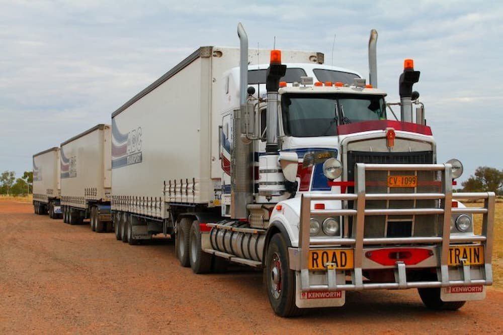
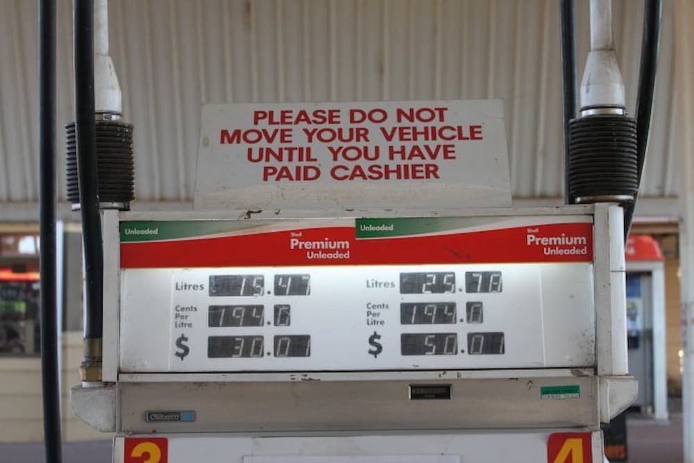
Driving on, we were reminded about how remote we were with a store that sold its goods for double the price of other major Australian cities, as well as a couple of statues of a male/female lizard (very cute) and an Aboriginal woman touting a spear (very massive). The next signs of life come via a gas station that markets itself as the most remote in Australia. “Road trains” – essentially gigantic trucks toting up to five loads of cargo (groceries, cattle, etc) behind them – were our road neighbors as we continued to make our way north.
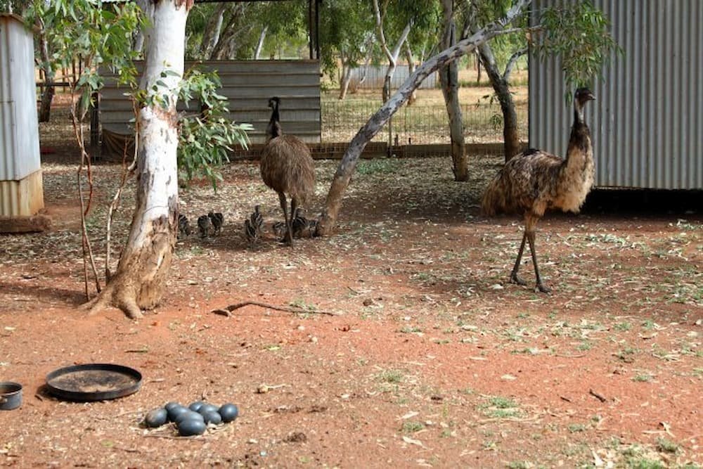
Lunchtime was at Wycliffe Well – the UFO capital of Australia, thanks to it having the most UFO sightings. The people that run the one little park/hotel/store/petrol station in the area have completely capitalized on this – there’s a little museum, as well as plenty of posters, including signs for the “malien” and “femalien” toilets (geddit)? There’s also a mini-farm housing a number of Aussie native fauna, including some very territorial emus guarding their eggs.


The main attraction for the day was the Devil's Marbles, a site sacred to its traditional Aboriginal owners. A deep brown color, there were literally dozens of huge boulders scattered across the flat plains. There were some boulders that showed clear signs of erosion – one looked like a massive salami, it had been sliced cleanly in half, exposing its white flesh underneath, while others were chipping in places. I felt like a kid again, clambering over piles of rocks to get the best shots.
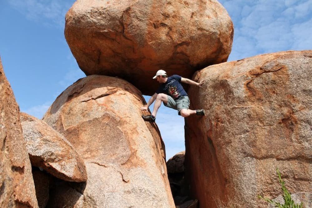
Besides these boulders, what also litters the landscape is the numerous termite mounds – this was the start of the millions more we would see as we went up to Darwin. Scaling up to a whopping eight meters in height and lasting up to 80 years, the mounds are hard as rock and made by termites gathering the surrounding dirt and spitting it out to create a hill that other animals can live in and birds can perch on, so they’re great for the ecosystem. They were amazing – some were stout, some had pointy tips, some were red and some were almost green/grey thanks to the color of the dirt that we went past.


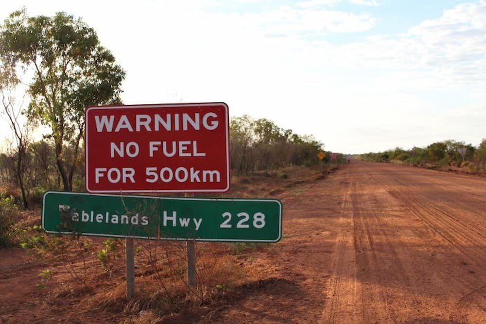
If Alice Springs is remote, the town of Tennant Creek just up from the Devil's Marbles is even more so. Sadly, the town’s liquor store is arguably the most popular shop for its residents. The Northern Territory has six times the alcohol consumption compared with other states in Australia, and the problem is so acute that there is a two-hour timeframe to buy cask wine (4-6 pm), while ID is scanned with every alcohol purchase. Getting to our campsite, we walked up a hill and looked out at the scenery – with the occasional road train and car driving past into the distance, we truly were in the middle of nowhere. Welcome to hot, dry, red, remote outback Australia.
If you ever want a sample of the quintessential Aussie humor, look no further (but do travel far) to Daly Waters Pub, an outback roadhouse for travelers from all corners of the globe. For example, next to the pub is a traffic light permanently on red (apparently a tourist waited there for about 15 minutes with no other cars in sight before catching on). Meanwhile, the store next to the pub sells various necklaces and other bric-a-brac, greeting you with signs like “The burglars (sic – burgers) are better at Hungry Jack’s”, “Next McDonalds – 285km” and a helicopter perched precariously on the roof above.
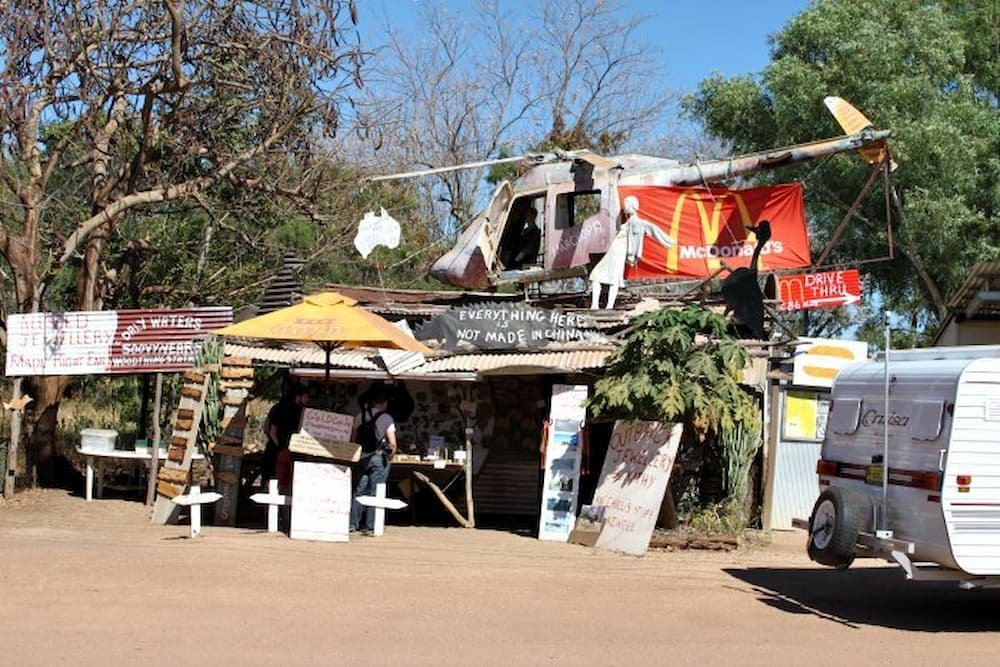
Going inside the pub, you can spend ages checking out all the memorabilia of travelers before you – people have left copies of their IDs, jerseys and even bras and underwear hanging from every corner of the room.
Driving on to Mataranka, right in the heart of the “never never”, people can come and soak in the thermal springs that are about body temperature in warmth. The springs are not very big though, so in peak season be prepared to be rubbing shoulders and feet with other people keen to take a dip – not particularly relaxing. You can walk around (about 1.2 kilometers) and see if you can spot any native wildlife like crocodiles or kangaroos, but other the walk is not particularly enthralling.


Arriving at our campsite before dark, fortunately, we had gathered more than enough firewood to compensate for the previous night, managing to dump all the wood to create a substantial bonfire. The heat was starting to pick up too – our permanent tents were sweltering and a few of our fellow friends were rather spooked by fairly large Aussie spiders lurking about. There was also a green tree frog stuck in a tap pipe in the men’s toilets – sadly, after rescuing the creature he leaped outside to freedom, only to be found shriveled to a crisp by the hot sun at noon the next day..!


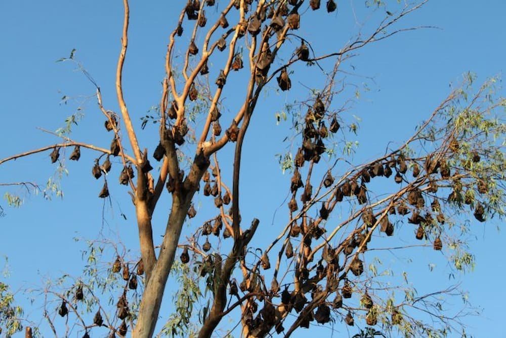
The next morning we had a sleep-in, not needing to depart until the late time of 6.30 am (woohoo!). Our stop was Katherine Gorge, where we could choose to walk, kayak ($30 for double, $45 for single), or go on a cruise ($60) down the spectacular waters. Despite the heat, you wouldn’t really want to go for a swim right by the shore – the trees nearby were completely infiltrated with bats (there were so many that they looked like brown leaves shaking in the wind), and the area was filled with the aroma of bat droppings.
Michael and I shared a kayak and paddled down to the first gorge (there are three) – this takes about 2.5 hours return, including time to go for a walk and sunbathe up to the rock face dropping down to the water below once you’ve reached the gorge. I’ve only been three times but I absolutely love kayaking – even though after a few hours my arms feel like jelly and I try not to think about each stroke so that I can keep on going. One thing that eludes me though is how to kayak and not finish completely saturated as I wind up splashing myself with every stroke. Is it possible to be dry the entire time?

The gorge is awesome – it’s fairly wide (but you’re told to keep to the right at all times so that boats can cruise easily past you in both directions), and you can see crocodile traps (we didn’t see any crocs stuck in them though – not sure if that was a good or bad thing), small waterfalls and an eerie little cave. The weather was perfect – warm sun and a blue, cloudless sky. We also had another chance to take a dip at the next stop – Edith Falls, a fairly rapid but small waterfall. It’s a 500-meter swim to get to the gushing falls. It’s a picturesque little spot, nice for a quick dip.

While the landscape of hot, outback Australia doesn’t vary too much, two major features continued to strike us – the first was the thousands of termite mounds that we continued to pass (it became a game to point out really tall or particularly interesting mounds to note while on the bus – the number of mounds in the Northern Territory surely outnumbers the Australian population), while the second was the amount of “back-burning” that was going on in the outback. In order to curb the spread of massive bushfires, the practice of pre-empting this in summer by purposely burning the dry grass in a contained area is common throughout Australia. Apparently, a practice conducted by the Aborigines before European settlement, it’s not an uncommon sight to see the skies being colored by lots of black smoke as back-burning is done in the distance.
Arriving in Darwin, we checked into our hostel, Frogs Hollow, separately to the majority of our tour, who were all staying in Cavanagh Hostel as they were continuing on for the next few days to Kakadu (we were going to Bali the next day instead).
I would have willingly eaten a cane toad to have stayed in Cavanagh instead of the skanky hole we slept in, otherwise known as a double hostel room. I could have put up with the loud, death metal music blaring downstairs. I could have put up with dirty showers that smelled like bad sex – even though they were right next to our room. But really, did I have to sleep on a bed that had sheets with mysterious, yellowed stains all over them, in a cramped room with mold all around it?
The day after our tour ended, we woke up from our hellhole (i.e. hostel), had a quick shower, and got the hell out of there. Starving, I made my way down to the communal kitchen to see if I could score some breakfast, but all I was greeted with were some crumbs, a few dirty knives, and not much else. So we wandered up to the city center and scored ourselves a fairly fancy breakfast to keep us going and to dust away the rest of the skankiest that we had just left behind. A swanky eggs benedict, toast, and coffee will do that to you.
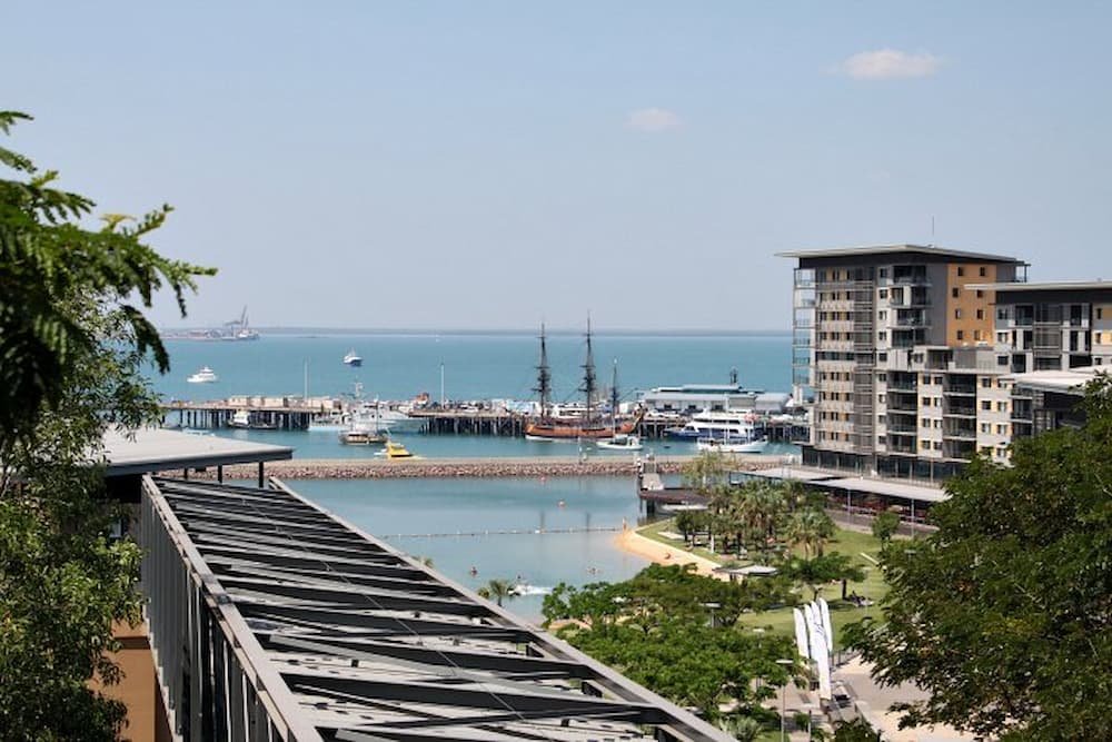
While Darwin is by the coast of Australia, it doesn’t have the pristine beaches that the east coast is known for (e.g. Bondi, Manly, Four Mile Beach etc). It is pretty swanky by the coast though – there’s a swimming pool with a man-made ‘surfing’ area where you can perch atop a surfboard and see if you can withstand the ‘waves’, as well as some nice sandy and grassy areas to sunbathe upon. This area is flanked by a boardwalk, as well as some expensive-looking cafes, shops, and residential apartments and offices. If you’ve ever been to Darling Harbour in Sydney, it looks a bit like a smaller version of that. Surrounding this area, you can walk to some of the other main buildings in Darwin – check out some parliamentary offices and the like.

We decided to skip the latter though and make our way to Darwin’s museum. It’s about a 15-minute bus ride outside of the Woolworths shopping center behind Mitchell Street (the main street in Darwin) – catch bus number 4, you can buy your tickets on the bus.
The museum has some interesting exhibitions, including some fossils from the Northern Territory that are thousands of years old, stuffed native fauna (did you know that two-thirds of all snakes in Australia are deadly?), Aboriginal artwork, and a dedicated section to Cyclone Tracy. This cyclone hit Darwin on Christmas Eve just over 25 years ago and the whole city was completely flattened, so it’s amazing to realize that everything that you see in Darwin today is a result of them having to rebuild. There are some interesting aerial shots before/after the cyclone and even a dark room that you can go in to hear what the cyclone sounded like when it struck – people that experienced the ordeal won’t go into this room, it brings back too many bad memories.

Besides the museum, most of the sites in Darwin can be found within the city center. While it’s not a big city, the main street, Mitchell Street, really comes alive every night as casual pub-goers mingle with their more upmarket bar-hoppers on the strip. There’s also a melting pot of cuisines available, from Thai and Chinese to standard Aussie grub.
I was embarking on a trip of a lifetime… starting in the middle of nowhere.
I had just finished up my job in Sydney and was going to be starting a new role in San Francisco, a city that I had heard great things about from all who had been there, although it was a place that I had never seen firsthand. Luckily I had arranged to have a month and a half vacation before starting work again, so here I was with my boyfriend Michael, spending a week in Australia’s Northern Territory on an Adventure Tours trip, before spending some time in Bali (Indonesia) and Seoul (Korea) before jet setting to the US of A.
June to August is winter in most of Australia. But with Australia being so vast, climates vary, and while Alice Springs faces the same fate as its southern cousins at night, during the day the temperature usually hits the generous mid-20s. We got off the plane from Sydney and were greeted with a warm 27 degrees – and not much else but a tiny runway, sundried shrubs, and passengers leaving the airport via bus or car, red dust flicking up behind them.

Arriving a day before our tour commenced, our bed for the night was at the Haven Resort, a hostel apparently close to the town center. We wandered up the flat, barren streets to town (it’s about a five-minute walk) and found a grocery, pharmacy, and a few fledgling restaurants – but not much else. People strolled aimlessly, while the shop where we ate our MSG-tasting noodles had staff who sat around bored, waiting for the next customer to arrive.
Honestly, unless you have a reason to stay longer, Alice Springs is a place to stay for just one night en route to somewhere more interesting, like Uluru or Kings Canyon. The hostel we were staying at was clean and we had managed to score a double room all to ourselves, TV and en-suite bathroom included. The beds are comfy and clean; it’s $10 for linen if you need any.

Waking up the next day for a 5.40 am departure from our hotel, we stumbled out to the darkness, meeting our guide, Ilse, as well as the 24 other tourists hailing from France, the UK, Holland, Italy, Japan, and Korea in our mini-bus that we would be with for the next three days. We would be making our way south to see Uluru (Ayers Rock), Kata Tjuta (the Olgas), and Kings Canyon before snaking our way back up to Alice Springs.
First stop after sunrise was camel riding. While camels aren’t native to Australia (they were introduced via the Middle East and the Subcontinent), they thrive in the Aussie northern climate and now number over one million in the wild. Here we found two, ready to be ridden on – costs you $6 for a couple of minutes. Ironically, besides riding a camel you could also eat one in a burger, in the café across from where they slept…


With Alice Springs being close to the heart of Australia, we soon made it up to arguably the most central point of the country. The actual center is open to debate as it can be measured in a variety of ways – median, gravity, etc. We also realized how remote we were when we saw the prices of goods at the gas station – petrol was a whopping $2 per liter (50c more expensive than other Aussie cities), while ice cream, water, and sweets were in some cases double the average price.

The Northern Territory hosts two dual UNESCO World Heritage places – only six other such sites exist. In the one national park, there is Uluru and Kata Tjuta – both giant rock formations that have come out of the ground and continue to evolve and erode to this day. Kata Tjuta, otherwise known as the Olgas, is Aboriginal for “many heads”. Interestingly, in the Aboriginal language the numbers only go up to three – then after that everything else is “kata” or “many”. In fact, there are 39 massive red rock formations, with the tallest well over the height of Uluru, which is in the Guinness Book of Records as the largest monolith in the world.
The surrounding land is as flat as a pancake, this is what makes these rocks even more amazing, as some of the formations are apparently as tall underground as they are above the earth. The color of the rocks is interesting too – thanks to the rich iron ore in the soil, the dirt is a deep red color. The rocks themselves have rusted over the years thanks to the iron, giving them this rich redness.

We trekked for a couple of hours around some of the “heads”, trampling across rocks piled high above each other, walking uphill to see a sliver between some of the heads where sunlight peeked in between, opening up to let us see the land below and the blue skies overhead. It is hard to describe the feeling that you get when you climb up a hill and check out the views – it’s simply glorious. While the rocks seemed fairly solid, in some places it could be quite unsteady as some of the stones continued to erode, exposing the grey original color of it underneath.

Next stop was Uluru, which is a few kilometers away, facing Kata Tjuta from across the plains. With the sun starting to set, we were here for a quick stop to have a sip of sparkling wine, cheese, and dips while overlooking the rock change its color, from a rich red to a shadowy purple. It’s a great idea – one that many other tour groups had capitalized on, as they set up their own champagne/cheese feasts in varying luxury.

Returning to our campsite, it was a dinner of camel (sadly, no I didn’t feel bad about eating the animal that I rode on earlier that day), sausages and salad before sitting around the campfire. With nightfall upon us, the temperature had dropped dramatically, but rather than sleep in the tents provided, most people chose to sleep in a “swag” beneath the stars. A true Aussie outback experience, a swag is a canvas bag that you can put your sleeping bag in – it has a big flap at the head to keep away the cold (or the mosquitoes) at night and is easy to roll up and dust off the next morning as you make your way through remote country. With a full belly and another fantastic view, despite the cold, it was easy to fall fast asleep.
Getting up at 5 am is not something that comes naturally to me. I never spring out of bed – and I definitely will not when I’m waking up in darkness, facing the freezing cold, sleeping on the floor next to a campfire that has dimmed overnight.
Yet on a holiday, we will overcome all of these obstacles in the quest to see that tourist attraction that we’ve been dying to check out. Today it was Uluru, or Ayers Rock, which is in the Guinness Book of Records as the largest monolith in the world.
As the bus made its way to Uluru where we would see the sunrise over it, the sun started to also rise and paint pastel pink, violet, and orange streaks across the sky. In the semi-darkness, we arrived and followed the green lights dotted across the footpath to where we could see the front of Uluru. Most people continued up the path to an elevated platform, however, Michael grabbed my hand and led me to the left where we stood on ground level with the massive rock.

It was absolutely freezing while we took a few customary tourist snaps, but then the unexpected happened. He proposed. I’ll spare the specifics other than to say that I was shocked, taken aback… but happily, said yes. Nothing like a romantic sunrise over a big rock to give me a big rock.. and make me overly emotional!

Uluru is 9 kilometers in circumference and most people don’t walk around it entirely – rather, they do what we did and walk half of that, which takes about 1.5 hours at a leisurely pace. It is well worth it – if you’ve seen pictures of Uluru on postcards they are taken from far away which gives the illusion that its surface is smooth – yet this is completely the opposite.
Up close, you can see not only the deep pockmarks that it has but also the thick, black, tar-looking residue from water that has slid down the rock over thousands of years. You can also check out a small watering hole on the base walk, as well as see some examples of Aboriginal rock art – the ones that you can see though are not very old, only about 150 years.

Uluru is incredibly sacred to the Aboriginal people, particularly the Mala tribe who were from the area. As such, there are areas where you can’t enter and areas that are strictly for women or men only. While you can climb Uluru if it’s not windy, the Aboriginals do request that you don’t do this for sacred reasons. Also, postcards will never have pictures of Uluru from the back – so unless you go there, you won’t know what it looks like (see the end of this post though if you want to read a description).* While many tourists did take photos of the back while on the bus, Mike and I decided not to.

Unfortunately, someone within the Mala community had died, which meant that we missed out on the opportunity to have a guided walk around Uluru with someone from the tribe. Luckily, Ilse was incredibly knowledgeable and provided us with a solid rundown of the area. We saw some bush tomatoes, learned about bush medicine, and found out about some Aboriginal myths and legends. Be sure to also check out the nearby cultural center to learn and see more about how Aborigines lived.

The next morning, we awoke again at the crack of dawn on our tour, leaving our campsite to go to Kings Canyon, a hiker’s dream. While we trekked through the canyon through winter (and yes, it was freezing the whole time – I wore four layers pretty much through the whole four-hour hike), there are numerous signs all over the place stressing the importance of drinking water regularly and ensuring that you have brought enough with you.
Be sure to drink lots of water in the warmer months, wear layers that you can easily put on/take off while walking, and also protect yourself from the sun even if you’re not walking in the middle of the day.

The trek starts off with a challenge almost immediately – trekkers are confronted with a steep hill with an almost vertical ascent leading 100 meters to the top. While it wasn’t fun with a blocked nose and a cough (Michael and I had terrible colds thanks to the winter we had left behind in Sydney), the views from above were well worth it. Similar to Kata Tjuta (the Olgas), the rock is a rich red in color thanks to the iron in the soil, however, beneath the rust, the rock unveils a marble white underneath. Also, the rock is incredibly brittle-looking in places.

Making our way across, we stopped at the “Garden of Eden”, a watering hole in the shade, where you could sit peacefully and look up at some of the massive trees growing overhead and birds flying around. The landscape from the top of the canyon is a lot drier – rocks are piled on top of each other, resembling stacks of crumbly pancakes or waffles in the wild, while the cliff face is a sheer, smooth surface in contrast.


There are more comprehensive walks that you can do, but unless you are an avid hiker, the four-hour walk sufficed. The hardest part of the walk is definitely at the start, but at the end it’s a simple step down some rock stairs, all the way back down to the parking lot.

*Uluru spoiler alert: So, you’re curious to know what Uluru looks like from behind, eh? From seeing pictures, most people get the impression that Uluru is longer than it is wide – but actually, the width of Uluru is about two-thirds the size. While there are still lots of pockmarks and black streaks across the rock on this side, one massive part in the middle has eroded to look like a profile of an Aboriginal person looking left… perhaps this is why this part of the rock is so sacred to the Mala tribe.
continued from Action and Adventure on Kangaroo Island
While our hotel is clean, convenient, and has all the amenities we need, if there’s one downside it’s the paper-thin walls. It also doesn’t help to be on the ground floor and have the hotel staff wandering the corridors, talking and vacuuming at 8 am. Needless to say, if you’re a light sleeper or a late riser, this isn’t going to work in your favor.
Shoving the sleep from our eyes, we got up in search of breakfast and a decent coffee, heading towards Chinatown and the central market. This area, which had been thriving with activity on Thursday morning, was a ghost town at 9 am on a Sunday. Managing to find the one bakery and the one café that was open, we decided to drive out of the city towards the Barossa Valley – home to South Australia’s (and even Australia’s) most popular and renowned wineries.
Not really knowing which route to take, Lisette plugged the address into Google Maps – which unbeknownst to us, lead us on the windiest route to get towards the Barossa. Great if you’re keen to explore the scenic route, but if you’ve been driving a lot over the last few days, have seen your share of national parkland, and have a blistering migraine-like Michael did, then we wouldn’t recommend it.
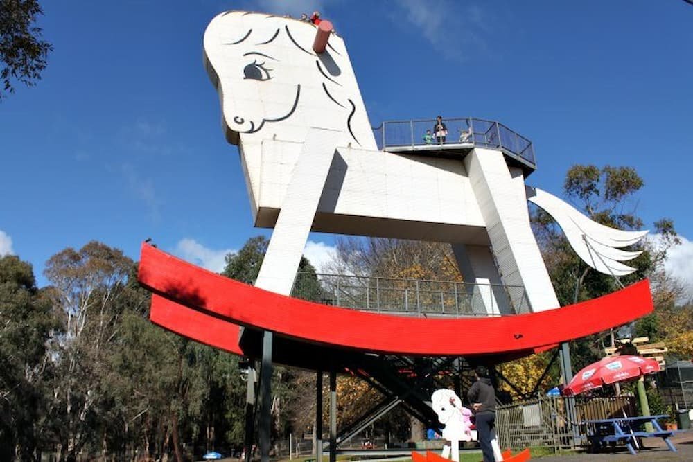
En route to the Barossa, we stopped in the town of Guneracha, home to the largest rocking horse in the world. Australia has a love affair with making the “biggest” monuments of something and this is one fine example. Built in 1981, this tourist attraction is fantastic for little kids – they can scamper up to the top of the horse and get a view of the people below.
There’s also the opportunity to go crazy checking out the various wooden toys and candy at the shop, and there’s a mini zoo (free entry, a bag of food pellets $2) where you can come face to face with native Australian animals such as kangaroos, galahs, and cockatoos, as well as guinea fowls, bantam chickens, ibis, alpacas, and goats.

There are dozens of wineries in the Barossa Valley as well as the surrounding areas. Being autumn (fall), many vineyards had already been harvested; however, there were still hundreds of vineyards that had leaves on the vine, which were a bright and beautiful golden color. Fortunately for us, the day was picture perfect – gorgeous blue skies and warm sun meant that the rolling Adelaide Hills, autumn leaves, lakes, and vineyards were bathed in their best light.
While some wineries only offer free wine tasting by appointment only, you can still spend hours upon hours traveling from one winery (cellar door) to another, sampling everything from fruity and refreshing white wines (think sauvignon blanc, pinot gris, chardonnay), rich reds (think shiraz, cabernet sauvignon), dessert wines and everything in between.
We had decided not to go crazy on drinking wines as a) we had just bought six bottles back in Kangaroo Island and didn’t want to be enticed to buy more, b) Michael was driving and c) we aren’t huge wine drinkers.
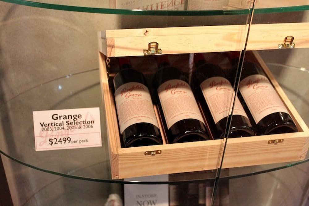
We did stumble on McGuigan’s Wines and highly recommend their award-winning 2010 Pinot Gris though, as well as a wander around the beautiful chateau that houses the tasting. With so many other wineries around though (from the highly commercial Penfolds to the more boutique offerings), it’s best to simply drive around and pull into the cellar door that takes your fancy.

Besides wine, another worthy stop was Maggie Beer’s Farm Shop. Maggie Beer is a household name in Australia, publishing dozens of cookbooks in our mothers’ generation and now experiencing a celebrity revival thanks to guest appearances on Australia’s MasterChef TV show and appearing on commercials for a major supermarket chain.
Her shop has daily 2 pm cooking demonstrations (cooking with verjuice), offers picnic fare food (no lunches), provides free samples of sugo, jams, chutneys, and other condiments, and sells other gourmet food lover items.

Amidst food and wine lover land, lunch wound up being oily pizza at 3 pm (although it was the gourmet option), before we headed to our last stop on the fringes of the Barossa Valley – a lavender farm. The farm, situated away from the main road, has been around for over 20 years and has over 90 varieties of the flower.
The couple who run it sure love lavender too – they sell anything lavender you can think of (perfumes, lotions, cookies, tea, ice cream, even shots with the ice cream). We settled for a few scoops of the ice cream, which had a little lavender sprinkle on top and had two chocolate sticks in it as well. While lavender food may sound a bit odd, the ice cream was delicious – it was a vanilla ice cream base with enough of a hint of lavender, but not too much that you felt like you were eating a flower.

As the sun started to set on our way home, we checked out the changing tones of the hills, plants, and lakes before making it back to the City. Our last Adelaide dinner was back towards Chinatown, which was once again bustling with people lining up to eat at the Cantonese, Szechuan, Thai, Malay, Korean, and other (Asian) restaurant options available (although there is one Italian, one Argentinean, and one burger joint around as well). Pretty much all restaurants were sufficiently packed inside so choose whatever suits your taste and budget – in order to compete, most restaurants prominently display their menus on the wall/door outside.
Refilling our bellies, we strolled back to our rice paper-thin lodgings for our last night sleeping in Adelaide… early start tomorrow before our 12.30 pm flight back to Sydney!
….continued from Impressions of Adelaide
This morning we woke to another inclement day and after a shower, we head to the General Store for a quick bite of breakfast.
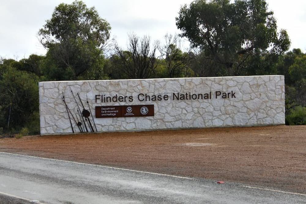
First stop on the agenda today was a good hour drive away at the far south-west of the island. We drove on the main sealed road past vineyards and paddocks before arriving at the Flinders National Park.
A quick stopover at the Visitors Centre was needed to purchase our park passes. In the center they had a great exhibition of animal skins and rock samples, it was quite an educational experience and would be very interesting for children (as everything is hands-on).

Another 15 kms into the park we encountered the Remarkable Rocks. These rock formations are perched on a cliff face near the ocean and make for a wonderful sight. We wandered around the rocks climbing and taking photos before heading to our next stop, Admirals Arch.

Only one kilometer along the road was a beautifully kept lighthouse that had been built in 1909 to try and put a stop to the large number of vessels that had been coming to grief nearby.
Walking down the boardwalk we encountered a large colony of New Zealand Fur Seals that were lazing on and around the rocks. There was a very pungent fishy smell but you couldn’t stop smiling at these magnificent creatures up close in the wild.
Admirals Arch was at the bottom of the boardwalk and made for a great snapshot as there were some seals perched below.


On our journey back we stopped again at the Visitor Centre and ate lunch. The food was delicious and I would highly recommend it. (So much so that we decided to grab some baguettes to have for dinner later that night).
We had planned to check out the seals at Seal Bay which was a short drive east of our cottage, but on arrival, the Park Ranger explained that it was another $27.50 pp fee to have a guided tour to the beach (really the only way you could get up and close), so we decided to give it a pass on this occasion.
The sun was now starting to fall so we headed back towards our cottage, stopping for a quick walk at Little Sahara (a number of white sand dunes that were just off the side of the road).
With the sun setting, we made it back home just in time for a brief stroll along Vivonne Beach before chilling out for the rest of the night.

After patches of rain overnight, we woke to our second day on Kangaroo Island to clear blue skies. If there’s one thing that we’ve learned about the Island, it can be sunny one moment and then drizzly the next.
With nowhere nearby to eat breakfast except Vivonne Bay General Store (and liquor shop and petrol station), it was a repeat of yesterday’s bacon and egg sandwich before we headed over to Kangaroo Island Outdoor Action to go quad biking and sandboarding (with time not on our side we decided to give kayaking down Harriet River a miss).
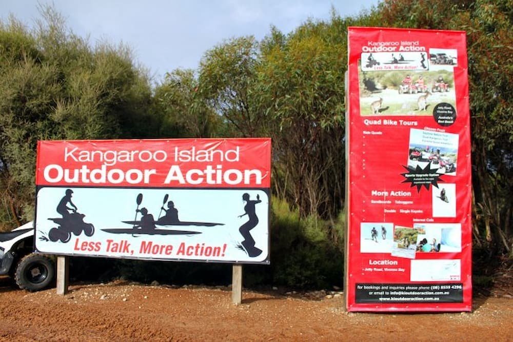
We had booked the 2.5-hour extreme adventure quad biking experience – which Lisette was slightly apprehensive about, given that she is rather uncoordinated on anything with four wheels and perches on the other side of ‘speed demon’ status.
However, with the company catering to children as young as six, we soon realized that quad biking is pretty easy to learn – the bikes simply need to have the ignition started, the start button pushed and the gear shifted to forward and you’re off.
Probably the only thing challenging is keeping your thumb continually pushed on the throttle to move – by the end of the adventure, it feels like your thumb is going to drop. You’re also more than adequately geared up – you get a helmet, gloves, and goggles before you jump on.

Our guide, Mick, was awesome – attentive, funny, and informative, he took us through open plains, windy paths, and incredibly bumpy trails where we encountered kangaroos, manmade lakes, sleepy koalas, funky native trees (including the spiky ‘black boy’) and lots of puddles!
We also had a brief pit stop to walk down to the beach below, admire the rugged coastline being lashed by some pretty ferocious looking waves, and check out a bee’s nest that had apparently been thriving there for years. Lisette still managed to almost run into a tree in line with her lack of coordination, but no serious damage to person or vehicle done.

Lunch was a drive 14 kilometers away to the Marron Cafe. Marron is a crustacean that is darker and bigger than a yabby – which looks like a cross between a lobster and a prawn. The Marron Cafe grows its own produce which means that the food is fresh and absolutely delicious.
Starving after the drive on the quad bikes, we practically inhaled our lunches – and if Lisette could have licked the bowl any further, she would have (the marron in garlic and parsley sauce, served with rice and salad with a balsamic dressing is divine, while the whiting with the cafe’s own lemon myrtle tartare sauce is worth raving about too).

Adjacent to the Cafe is the marron viewing area, where you can learn about the breeding process. In about a dozen deep vats, about 5,000 marrons were categorized by weight, awaiting their fate to land as cafe meals or to be sold commercially. We settled instead for some wine tasting, which lead to us getting five bottles of Pinot Gris and a pear liqueur being mailed to us within a week’s time.

The thought of scampering around the sand dunes of “Little Sahara” on a board, on our bellies, then doing it all over again was enough to make our seafood and wine-filled bellies churn. However, we drove back and tried it out. Michael was a natural at sliding while Lisette… well, if she’s uncoordinated on four wheels I’d say that she’s even more so on a board.
My tips for a successful sandboard? If you’re using a toboggan-style board, make sure it’s well waxed on the bottom each time, run across the top before sliding onto the board, and slide on your belly rather than sit on the board to get more control and speed.

Rushing back to our lodge to shower and pack, Michael used his newly-acquired speed demon skills to zoom halfway across the island in time for a quick dinner and ferry ride back to Adelaide. The only place open near the terminal was a rather classy-looking pub.
If there’s another thing we’ve learned about the Island, it’s that the food is absolutely delicious – and incredibly gourmet. How does dukkah-coated snapper served on a bed of Asian greens and mango mayonnaise, or a red chicken curry with julienned vegetables with a side of jasmine rice sound?
Just making it on time to catch the ferry, after 45 minutes it was back on the mainland and what felt like a long and tiring drive back to our hotel in Adelaide. Finally arriving, we both had hardly hit the pillow before we were sound asleep.
Want more? Read the next article here: Wine Tasting in the Barossa.
Lisette and I have made it a mission to explore more of our own backyard before we head off for our big move to San Francisco. This trip to South Australia actually completes my circumnavigation of Australia, having covered all States and Territories (Lisette is close behind with only Western Australia and Northern Territory remaining).
Our trip began with us arriving over 1.5 hrs prior to boarding, waiting in line for ages before the check-in lady called for anyone going to Adelaide to move to the front of the queue. There was a rush as most people were on that particular flight. Then when we got to the counter our bags weighed in at 22kg (7kg overweight and they wanted to charge us $20 per kilo – $120) we decided to move to the side and try and re-pack a bit (wondering if it was even possible to remove 7kgs)
The end result was putting 3 jackets on, a hat and now had 3 heavy pieces of hand luggage. It was very hot and very stressful (not to mention the fact that I must have looked like a drug mule or something)
Then Lisette realized she had lost her boarding pass – we were running out of time to get some food too so we were both getting a little grumpy.
After some Mcdonalds, we walked to the gate only to find out that our flight was delayed over an hour (thanks Tiger Air).

On arrival we got our hire car and drove into town… a journey of only 10-15 mins, arriving at the Wright Lodge only to find another guy that had been on our flight waiting out the front. He said that the door to get in was locked. I called the number and spoke to a Chinese girl who had no idea what was going on and couldn’t find our booking.
Eventually, we sorted it out that they had put it under Lisette’s name and there was a letter sticky taped to the window of another entrance.
Once inside it was a maze… we couldn’t find our room until we ended up walking out the back where there was a laundry and woke up an old Chinese lady who spoke no English but pointed the way for us.
The room was a decent size with a small kitchenette but was quite musty smelling and the sheets looks brownish (not dirty… just old)

There was a multitude of building noises throughout the night and the walls were paper thin. So much so that I heard the entire conversation of “John” (who I established was in the room next to us), calling a taxi at 5 am to go to the airport. After a very poor broken sleep (Lisette slept through it all) we woke and I went to pay for parking.
We realized after a short walk that we were right behind Adelaide’s own Chinatown, which as every city’s Chinatown has greeted us with its traditional red arches. After a simple breakfast of coffee and ham and cheese croissant/egg and spinach brioche, we rushed back into our car to make it before the parking inspector got to it.

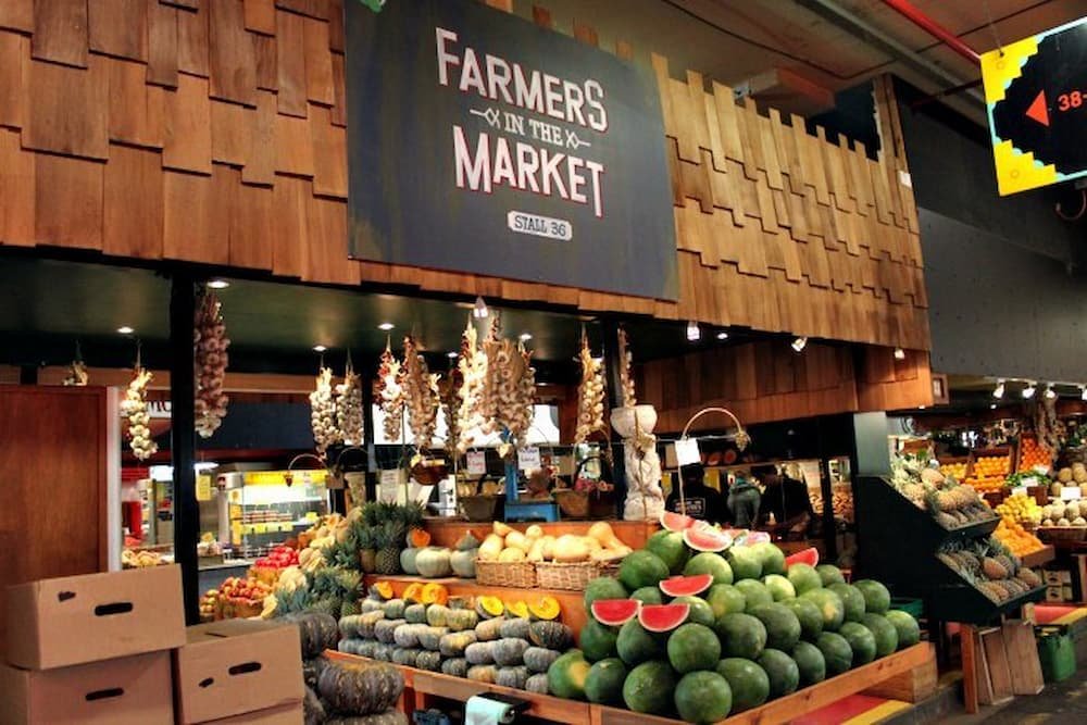
Fortunately, we found out that while the city itself has parking meters, within a short walking distance away the parking spots have no meters at all. Returning to Chinatown we made our way to the central market, a busy hubbub to find the best and freshest produce – seafood, meat, fruit, vegetables, cheeses, coffee, confectionery… there were dozens of stalls selling it all. The food looked amazing and everything looked incredibly fresh and picture-perfect. Lisette could have spent many hours (and many dollars) hanging around in there – but alas, we only wound up buying four mandarins.
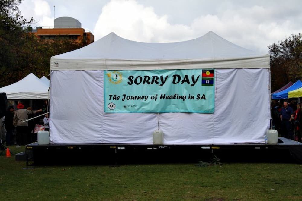
The next step was a stroll towards the city center, stumbling across parks and churches along the way. It was ‘Sorry Day’ – Australia’s apology for mistreating the indigenous population during and after settlement – and there were a number of stalls in the park celebrating the occasion.
The city was small and clean and had the typical strip of chain stores that you’d find across any major city in Australia – Review, Myer department store, Sportsgirl… so we didn’t spend much time wandering through here. Rushing back towards central market we stuffed ourselves with some decent food court lunches – Japanese miso ramen. Interestingly, the choice of cuisine is entirely Asian – Taiwanese, Japanese, Korean, Chinese, Vietnamese, and Thai were the options.
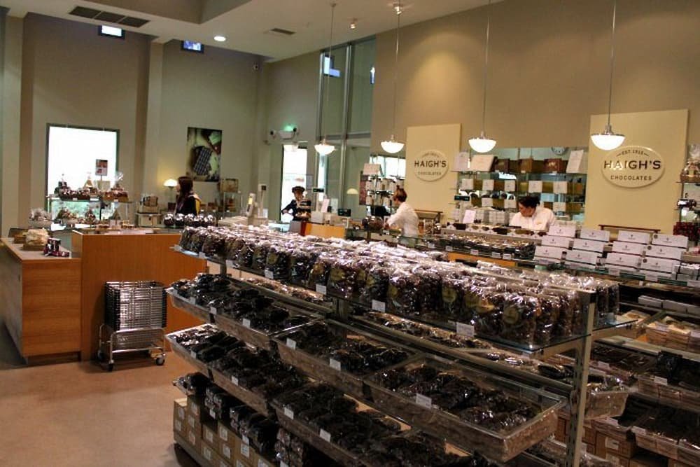
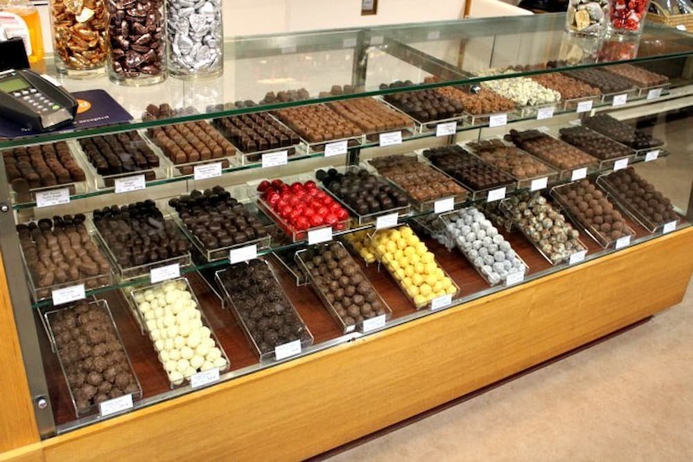
Still left with room for dessert, next stop was the famous Haigh’s chocolate factory, a South Australian icon, where we had a 2 pm factory tour booked (note these tours are for free but bookings are essential). After learning about the process of making chocolate and seeing some of the processes in action (hand-rolling chocolate truffles, creating mounds of almond clusters, individually putting little lemon candies on each piece of lemon myrtle cream), we had a newfound sense of appreciation for the time and effort spent creating each chocolately masterpiece. So much so that Lisette decided to buy a whole collection of these individual creations and a packet of rocky road (despite the collection of free tasting that we got during the tour).
After a quick tea and coffee, we were off again to the beachside suburb of Glenelg, 30 minutes from the city. The sleepy little suburb is reminiscent of the English seaside town of Brighton, with its streets of cafes, shops, and pubs, as well as a little museum which had some interesting photographs, paintings, and sculptures from local artists.

Getting back into our car as patches of rain started to hit, we had a quick stop at the Old Gum Tree. Situated within a small park in a residential area, this unassuming tree is the site where Adelaide was founded in 1836.
From there, it was 1.5 hours drive south to Cape Jervis, to catch the last ferry to Kangaroo Island, with a quick stop at a tavern beforehand to get some dinner. The ferry takes vehicles onboard and takes 45 minutes to get to the other side, even though the Island is only 15 kilometers from the mainland.
Arriving at Kangaroo Island at nightfall, we were meant to only take an hour or so to arrive in our little cottage – Honeyeaters Hideaway – however with the roads lit only by street reflectors, trying to navigate proved extremely difficult (and we had no cellphone reception – note if you are with any provider other than Telstra you are screwed). Luckily for us, we stumbled upon a Telstra payphone to call the lady who owned the cottage, who then directed us to where we were staying. Finally arriving in the pitch black, Michael searched for what felt like ages to find our cottage keys which were apparently in the electric box – only to realize that they were in the door.
Dumping our luggage on the floor of our cozy cottage, we crashed out for the rest of the night. Zzzzzzz…
Read the next episode here: Action and Adventure on Kangaroo Island.
continued from Part 2 ….
After a great night's sleep on the side of the road, we woke up to the sound of a National Park Ranger’s car pulling up behind us. The two rangers got out of the car and walked to our side window to check if we were in the van. They asked for our park permit as we had apparently misread the signage and were camping inside the National Park. After a short conversation, they advised us that we had to go and pay for the permit at the Ranger Station and took our details.

We decided that we would go and grab some breakfast first at Coles Bay and after a short drive, we found a nice little cafe near the boat ramp. The lady owner was really nice and told us all about how the cafe nearly burnt down just recently and that her husband was still in the hospital from fighting the fire.
We then went and paid the fine and asked for some details about the best way to go and see Wineglass Bay. It was suggested that we go and check out the lighthouse first as there was hardly any wind in the morning so the best time to check it out. I was surprised to see that there was a disabled access sign as the walkways were very rocky and would be difficult to negotiate in a wheelchair.

The boardwalk wrapped around the coast and the lighthouse and gave some breathtaking views up and down the shore and out to a small island outcrop. We saw a number of different birds and a small lizard before making it back to the van.

Our main reason for wanting to come back to the east coast was to see Wineglass Bay (one of Australia’s best beaches). The walk to the lookout was a few kilometers but more importantly, the surface was rocky and the track was quite steep in parts. After days of freezing cold weather we had been greeted with gorgeous 20 degrees C and blue skies so the trek to the top actually worked up a bit of a sweat believe it or not.

Once at the top we were treated to the most amazing view of Wineglass Bay, the contrast of the white sand and the crystal water made for a great photo as you can see. I wanted to go one further and looked around for a better vantage point by climbing around the rocks and setting up the tripod. The photo wasn’t much better but I felt more adventurous by making the effort.

After we had taken our happy snaps we both decided that the walk up was enough and we decided to come back to the van rather than push on down the other side to the beach since we were both feeling pretty hungry by now.
Lisette had set her sights on sampling some of the famous seafood that Tasmania has to offer for lunch and we had seen a small cafe on our trip into Coles Bay the night before which seemed like a good option.
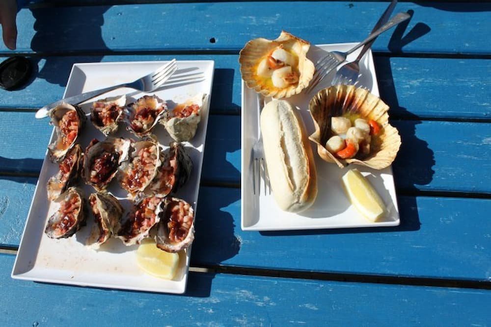
Driving along the main road out of Coles Bay we almost missed the turnoff to the cafe and had to circle back (not an easy task in such a long van). It was worth the effort though…. the most delicious scallops and oysters you could imagine and decent prices too. It was a very simple setup with a small caravan and an outdoor dining deck but that’s all we needed as the food spoke for itself.
It started to get a bit chilly as the wind was blowing onshore which forced us to move on rather than sit and enjoy the sunshine. When I drove in I had to negotiate a small sandy bump and now that we were leaving it seemed that our van was stuck fast in the sand and wouldn’t budge. I moved the van as far forward as possible for the best run-up and revved the life out of it….. Yay! We just made it over the bump and were on our way again off to Bicheno.

The drive north along the east coast was very picturesque and our next stop was the blowhole just north of Bicheno. Here the distinctive orange color on the rocks is from the algae growing in the area giving the rocks a rusty look. There was a small crowd of people watching as the ocean swell vibrated beneath us forcing water up into the air from the blowhole.


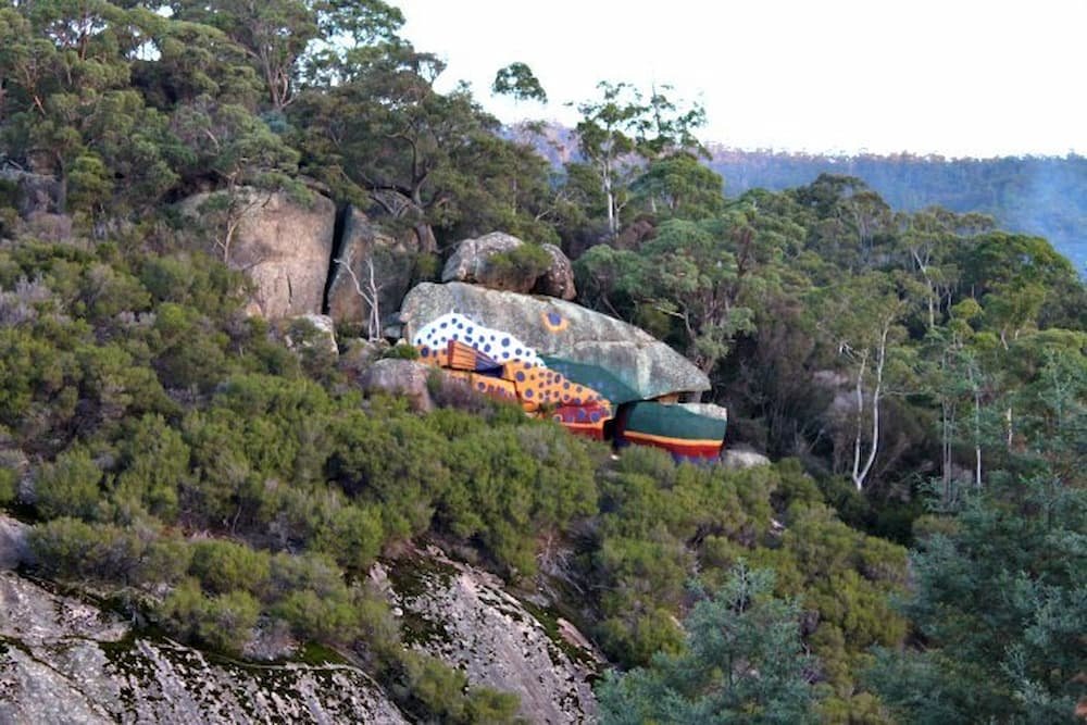
The drive continued up the coast towards the Bay of Fires which was our final stop for the day. On our way, we drove past an interesting rock by the side of the road that was painted to look like a trout.
Arriving at the Bay of Fires just before sunset we watched the orange glow encompass the horizon, a very romantic setting. The time was now approaching 6 pm and we needed to be in Launceston the next day to drop off the van and catch our flight home so I jumped back in the driver's seat and pushed on through the darkness…destination Launceston.
It was a pretty decent drive but a rewarding sight as we came down from the mountains to the city lights… a sight we hadn’t had for some days now. Parking the van we wandered the city streets looking for a bite to eat but hadn’t factored in the Easter holiday closures. The best we could find was a shopping center food court that was only open because of the cinema located next door.
That night we parked the van on the side of the road in a suburban street and set the alarms for the following day's trip home.
The day started at a service station by cleaning out our rubbish and filling the water and petrol tank before dropping the van back at the depot across the road from Launceston airport.
I nearly lost my iPhone by leaving it on the seat where I was checking my emails but luckily for me a young girl had noticed and ran after me to give me the phone before we checked in.
The trip was over and we declared it a great success, vowing to return to the north of Tasmania to check out the towns we missed on this trip.

continued from Part 1….
Woke up around 9 am (early in comparison to the night before) after stopping on the side of the road in Derwent Bridge. Kept on driving – lots of windy roads – the roads were also incredibly mountainous – particularly as we got towards the mining community in Queenstown.
Stopped over for a quick ham/cheese/tomato toastie and coffees (not sure it really provided the caffeine kick we were after, especially as Lisette continued to snooze on the drive-through). The weather in Tasmania, we have found, is incredibly volatile – it can be sunshine and blue clouds one moment, then the clouds will quickly fly through and it will be bucketing not too long afterward.
The latter was the case as we drove through more towns – Hamilton, Strahan… (which on the map look huge but if you are not going on a harbor cruise through the latter, there really wasn’t much point for us to stop there). So we kept on driving through the grey and rain until we got to our destination – Cradle Mountain.
Arriving we found that there were, fortunately, a few spots for us to camp for the night – and that quite a few of our neighbors were roughing it in the rain, with tents to sleep in overnight. Brrrr…

After a quick shower (Lisette had luxury after a couple of days of being stinky with a warm shower and a hairdryer, while Mike could only get boiling-to-the-point of unbearable to I-am-freezing-to-frostbite cold), and some instant Korean noodles (mmmmm….spicy) we wound up in the recreation hall to type out a few stories and watch some DVDs.
Later that night we were feeling quite peckish so decided to venture out in the van to find somewhere to eat. It was now about 8.30 pm and the choice was very limited. We ended up at the Cradle Mountain Lodge as they had a gourmet buffet on that night. It was a little bit expensive but we ate a ton of food… so much so that Lisette felt like throwing up afterward.
After a cold, wet night reaching near sub-zero temperatures, we woke to a clear and more importantly dry day. We set off to the national park center to get the shuttle bus up to Dove Lake where we would start our hike.
A couple of tour buses had arrived at the center just before we got there so we had a long wait for the shuttle. In that time, standing in the cold line, we watched as a tour helicopter took a bunch of tourists on a scenic flight over the park…wishing we were also on it.

On our way out to Dove Lake we watched and listened as the driver made repeated calls on the CB radio to notify the other shuttle drivers of his location. The calls were along the lines of “42 out”, telling the other drivers we were at marker 42 on our way out (this was all due to the narrow road making passing very difficult).
We arrived at our stop and went to register our names in the hiker's log book. The weather was freezing as the wind bounced off the icy lake.

The hike we had decided to do was the Dove Lake Circuit which had fantastic views of Cradle Mountain and the surrounding bushland including a number of waterfalls, a distance of around 6.5kms. The natural landscape was quite rare as this is apparently one of the only cold weather rain forests in the world. We made our way along the well-maintained boardwalks through dense forest covered in thick green moss, past secluded beaches, and rocky outcrops for the next 2 hours.

There was an interesting mix of tourists that we encountered on the walk, from speed walking backpackers, to an asian lady in 4-inch heels (surprisingly she managed to handle the terrain quite well).
Once we got back to the start point and signed off in the logbook we joined the end of the queue and waited for the next shuttle to take us back to the Ranger’s Station so we could begin our long drive towards Bicheno on the east coast of Tasmania.
The drive took us through winding mountain roads and the scenery was great (even though I couldn’t really take it all on while concentrating on the road ahead). We did however stop at a mountain pass for a quick stretch and happy snap.

Our next stop was at The Honey Farm near Mole Creek. We noticed the shopfront as we were driving past and decided to stop for a peek. They had a small museum and gift shop selling every imaginable honey product you could think of. I ended up having a honey ice cream and Lisette looked after the mothers day gifts.

As we drove on our tummies started to rumble and we were craving a good old Aussie burger. Unfortunately, this turned out to be a bad choice as we managed to find the worst burger place in all of Tasmania…. both our burgers were swiftly thrown into the bin as we walked out of the shop.
The road had now started to open up as we headed towards Launceston on the highway so we started to make good time on our way to the coast. As we neared the coast road the sun had just set and the wildlife started to make its way out onto the road again…resulting in an increase in my concentration.
Finally, we arrived at the coast and made our way through Freycinet National Park to Coles Bay where we had decided to spend the night. Once we arrived in Coles Bay we looked for a suitable parking spot so we could get some rest. We decided on a small dirt parking spot by the side of the road just outside the national park entrance.
In our next post you will discover that this spot was not all it was cracked up to be………. read about it here: Around Tasmania in a Campervan – Part 3.
Finally, we are able to spare some time to write about our recent trip around Tasmania over the Easter weekend. We decided that the best way to get around would be in a campervan so we were free and easy. It turned out to be a great plan as you will read in the article as it gave us the opportunity to see some unique creatures in the wild.
In preparation for our morning flight, we set our alarms nice and early and caught a cab to the airport in peak hour traffic. It’s amazing how a simple 20-minute journey can turn into 45 mins in crazy traffic.

We boarded our flight to find out we were sitting at the back of the plane and had a French couple with 2 young girls seated in front of us on our Virgin Blue flight. Let the screaming on takeoff and landing begin…. Now I can typically handle screaming kids but this time was really quite annoying as the mother couldn’t give a shit and didn’t comfort the girls at all.
On our descent, a voice came over the intercom telling us that we couldn’t bring fruit into Tasmania. DOH! We had packed 6 mandarins in our carry-on bag so we had to scoff three each in 20 mins.

We arrived to a cold day and while waiting for our bag at the turnstile a police sniffer dog came and sat down next to me (smelling the mandarins that were previously in my bag), the lady officer asked if I had any fruit and I explained the situation… meanwhile every passenger was starring at me (presuming I was some sort of drug mule) while I went through my bag showing the lady that there was nothing there. How embarrassing!


Picking up our campervan we drove off to Hobart city and to our first stop which was the Cadbury Chocolate Factory. En route we stopped in at a pub and had rissoles and lamb roast for lunch and played a game of keno…$1 we will never get back…
At the Cadbury factory, I managed to get in free after I flashed my travel agent license from 2005. Being Easter we also got given 2 chocolate bunnies. Checked out the gift shop while we waited for our tour. During the tour, the lady explained all about the chocolate-making process and we got free samples of Cherry Ripes and Flakes but still made a few purchases for the trip back at the gift shop before heading off to Hobart again for dinner as it started to rain.

Got to Hobart and checked out the harbor where we saw the old P and O research ship that goes to the Antarctic. Then went to check out the Salamanca area (where they have the Salamanca markets on a Saturday). Shopped for some fresh fruits, cheeses, and stocked up on cereal and milk for the trip.

While taking a photo out the front Lisette was accosted by a guy with a white beard who wanted to know absolutely everything (personal) about us. He was friendly enough but after a few minutes, it seemed to be more of an interrogation so we did our best to lose him.

Drove around Battery Point and looked at all the old houses and shops, then we drove to Wrest Point and went for dinner at the casino bistro. The all-you-can-eat buffet was more expensive than we were willing to pay for and we weren’t that hungry so went to one of the other restaurants instead.
I had the Thai chicken salad with hokkien noodles and Lisette had the smoked salmon ceasar salad (mine was the winner on the night).
Got back to a cold car and decided to drive through the night to Port Arthur where we would camp out at a car parking area until the morning.
Woke up to many cars and campervans driving past us – after a freezing night (with Lisette practically suffocating the claustrophobic Michael), it turned out that we had slept till 10 am or so!
We walked down to Port Arthur entrance – they close late as they do ghost tours as well. The cheapest ticket you can buy to get in costs $30 (bronze pass), which gives you access to the area, a guided 30-minute tour, and a 20-minute harbor cruise. You also get playing cards where you can ‘be’ a prisoner and find out about the convict’s life.

Really informative and educational tour about Port Arthur and its convict history – can see how you can easily spend a whole day wandering the 90 acres or so. Over the 47 years that it was in operation it had about 7,000 prisoners walk through and toil on its grounds, with about 1,100 dying and being buried on Death Island across the water. Besides the various penitentiaries and housing for the governors and soldiers, you can find a couple of museums, a shell of a church, and another Anglican one on site.
We went on the harbor cruise first and found out that it was really hard to escape – you could try swimming (someone tried to make a boat out of a beached whale’s carcass), but it was all but impossible to leave.
Unfortunately, when it came to our guided tour it bucketed down with rain and our group was standing under a tree looking fairly miserable as the wind blew more rain in our direction. Our pleasant tour guide tried to make the most of a dismal situation, by cracking jokes (not sure if it was more for his sake though).

Port Arthur was really revolutionary for its time as it was not just a place of punishment – it was aiming to provide reform for the men. In some cases, it did succeed. When the prison shut down it was renamed as Carnarvon for a while with the aim of being a place people could live, but so many tourists (and honeymooners) wanted to visit it for its prisoner history that soon after it reverted to its old name, with many convicts taking tourists around.

We then went straight to the Tasmanian Devil Sanctuary which housed not only 30-odd devils but also a menagerie of birds (tawny frogmouth, rosellas, parrots, peregrine falcon, etc), as well as quolls, wallabies, and kangaroos.

We made it in time to see the devils being fed (scavenging around as they do by nature and attacking each other for the pieces of meat), as well as seeing a bird show, trooping after wallabies and kangaroos (but staying a while away from the geese).
Sadly there are not many devils left in the wild – many are being killed off by a mysterious cancer that is spread from one devil to another when mating or biting each other when playing. The devils that are in the sanctuary are cancer-free. Interestingly their life span is only 5-6 years and while the mum can have up to 15 in a litter, she can only raise 3-4 at a time.


Starving we then went to have lunch at Eaglehawk Neck (named Doo Town) – fisherman’s cone! With battered fish, scallops, calamari rings, and lots of chips. Checked out the blowhole (which was barely blowing) and then up to Fossil Point where lo and behold – there was a pair of orcas swimming around!! Yay – took some awesome shots.


Then came the long drive towards Strahan – the wildlife spotting continued, with a couple of wild Tasmanian Devils, lots of scampering wallabies, mice, and possums – and unfortunately lots of roadkill. Luckily we weren’t the cause of the roadkill (although there were a couple of very close calls). This was all through the night – as they are nocturnal animals we were very fortunate to encounter them, although the road was incredibly windy so you definitely need to be a confident (and not a fatigued) driver to navigate, particularly as the road is not well lit (high beams beaming!)
I decided that I had driven enough for the day and we stopped by the side of the road at Derwent Bridge to sleep for the night. In our next post, we head to Cradle Mountain. Read it here: Around Tasmania in a Campervan – Part 2.
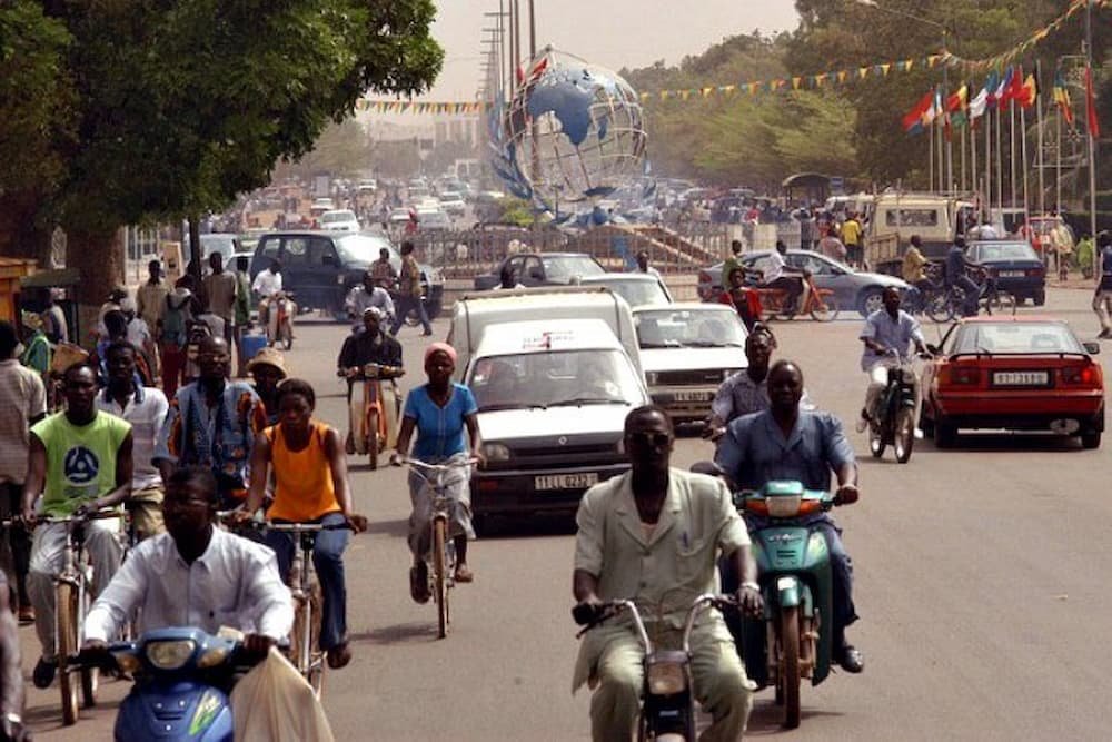
Located in heart of West Africa, Burkina Faso is the sort of place that captures the imagination – how many of you even knew that Burkina Faso exists? This may be one of the world’s poorest countries, but it’s also one of the most stable in the region and runs with an efficiency that’s the envy of many of its neighbors.

Burkina Faso has a primarily tropical climate with two very distinct seasons. The rainy season and the dry season where the harmattan (a hot dry wind from the Sahara) blows. The rainy season lasts approximately four months from June to September and is shorter in the north of the country.

The cuisine of Burkina Faso, typical of West African cuisine, is based around staple foods of sorghum, millet, rice, maize, peanuts, potatoes, beans, yams, and okra. The most common sources of protein are chicken, chicken eggs and freshwater fish. A typical Burkinabe beverage is Banji or Palm Wine, which is fermented palm sap, and Zoom-kom. Especially the town of Banfora is known for its good quality Banji, though one should be wary of the Banji sold by hawkers as it is often not very fresh and may contain added water.

Visitors in June and July must try the caterpillars known as “chenilles”. The caterpillars come fried and can be eaten crunchy like french fries or put in a baguette as a sandwich.
Two key elements of culture in Burkina Faso are its indigenous masks and dancing. The masks used in this region of the western Sahel are made for rites of sacrifice to gods and animal spirits in the villages. Native dance, on the other hand, is employed to demonstrate the villagers’ desire for blessings by the spirits.
The cinema of Burkina Faso is an important part of West African and African film industry. Burkina’s contribution to African cinema started with the establishment of the film festival FESPACO (Festival Panafrican du Cinema et de la Televison de Ouagadougou.
The West African Franc (CFA)
As with many West African countries the main global language is French. Other local languages include: More, Fulfulde, and Lobi.
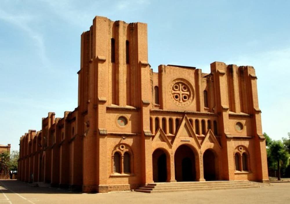
Bobo, as it’s widely known, may be Burkina Faso’s second-largest city, but it has a small-town charm and its quiet tree-lined streets exude a languid, semitropical atmosphere that makes it a favorite rest stop for travelers. It has a thriving market, a fine mosque, and a small popular quarter, Kibidwe, which is fascinating to roam around. There’s also a lively music scene.

The beautiful Grande Mosque, in the old part of town, is a good example of Sudanese mud-brick architecture with its towers and wooden struts. The best time to visit is at sunset when the facade turns a golden color and the locals pass by pausing for prayer. Le Grande Marche is a huge, colorful market that offers just about everything you need to live in Burkina Faso. From cloth to plastic buckets and jewelry to gas lamps as well as a selection of fruits and vegetables, the market is great for picking up souvenirs.
The modern Cine Sanyon is an excellent cinema that shows good films, including runs and reruns of Burkinabe productions which have won international acclaim, as well as dated Hollywood blockbusters and Jackie Chan flicks.

Most travelers end up liking Ouaga (as locals call it). While it could just be that the city’s name rolls off the tongue in a wonderfully rhythmical African way, there’s no mistaking the fact that, for the capital of the world’s third poorest country, Ouagadougou is surprisingly upbeat, friendly, and home to good hotels, restaurants, and nightspots.
The gateway to the Parc National des Deux Bales where the elephants roam, is the sleepy town Boromo in Southern Burkina Faso.
A few weeks ago Lisette was scanning through the daily group buying deals to see if there was anything interesting when she came across a 2-for-1 deal on Cudo. It was for a 4 hour Middle Harbour Eco Tour with Sydney Harbour Kayaks (a big change from the normal health and beauty or restaurant offers).
Well, last weekend we had the pleasure of taking the tour…. and boy did it live up to expectations!
The morning started at 8.30 am with a comprehensive briefing on safety and how to paddle correctly in a kayak. It’s actually quite interesting how much of a difference a little technique can make in both speed and performance but more importantly in how sore you feel the next day.

We had gone canoeing over the Christmas break in Jervis Bay and I can tell you that my technique must have been horrible as I was in pain for days after.
The obligatory ‘name and shame’ of the group followed when our guide made us introduce ourselves and say where we had heard about the tour. Needless to say, EVERYONE had purchased it through Cudo. Shameless promotion I know but you have to admit that these group-buying sites are powerful. In fact, our tour guide (Sol) explained that they had 2,500 people purchase the coupons and were subsequently booked solid.

After a quick setup of our rudder, we were in the water. We started by paddling out and across the harbor from the Spit Marina and I guess I mustn’t have been listening in the briefing as my arms were already sore. Luckily for us, the weather was perfect though, zero wind, gorgeous blue sky, and about 28 degrees.
Paddling under the Spit Bridge we were surrounded by mega luxury yachts and cruisers on one side and multi-million dollar waterfront houses on the other. In fact, one of the houses was designed by the famous architect Jorn Utzon who is responsible for the iconic Sydney Opera House.

We continued around a few bays making sure that the group stayed relatively bunched and hugging the shoreline for safety. It was amazing to see how much isolated parkland there was considering we were still smack–bang in the middle of Sydney. In fact, Sol pointed out that the geographic center of Sydney was up a small tributary not far from where we were.
I was now starting to have a few issues with my butt and left leg going numb. I guess it was because our rudder was a little off-center and I was constantly battling it to stay on track. About 1 hour 45 mins into the paddle I was praying for a break and luckily for me it wasn’t too far off.
When we hit the halfway point we paddled across the bay to a beautiful little beach landing that was very secluded. We had a bit of an explore while Sol set up the picnic for morning tea. By this time both Lisette and I were famished so we happily devoured the cheese and crackers, Tim Tams, and sliced watermelon washing it down with a cup of coffee.

Once we had let our food settle a bit and had a good chat with some of the other group members we were off again. Making our way around the next point Sol explained some of the history of the area. There were some old buildings to our left that were used as ‘powder houses’. These fortified buildings were used to store the explosives for commercial demolition back in the day. There was a big sign warning not to dock….we didn’t want to take our chances.
Knowing that we were now on our paddle back I was amazed at the transformation of how I felt. I started to get a good rhythm and the pain had gone away which made the paddle so much more pleasant.

Just before we made it back to the marina we came across a young family with 3 children paddling in a canoe. The kids were so excited to see our group and yelled out to challenge us to a race. It was on! I have to let you know that both myself and Lisette are rather competitive people and we didn’t want to go down so we paddled like there was no tomorrow. There was yelling back and forth “we are winning…no we are winning” and in the end, it was too close to call.
The last stretch of water and a headwind had picked up which made us really work hard to get home. Finally, we made it back and said our goodbyes before grabbing our stuff and heading home. It was a great morning out on the water and I would definitely recommend the experience if you have time.
